Nandaprayag – Sacred River Confluence Town in the Himalayas

Nandaprayag , Joshimath
Tourists visit Nandaprayag mainly to witness the meeting point of two rivers and as part of pilgrimage routes in the Himalayas. It is one of the Panch Prayag and is known for its river confluence and valley setting.

Quick Facts About Nandaprayag

Nandaprayag, Uttarakhand Quick Facts

Entry Fee No entry fee for visiting the confluence area and town
Timings Open 24 hours; nearby temples follow their own specific schedules
Altitude (m) Approximately 900–920 m above sea level
Ideal Visit Duration 1–2 hours for the confluence viewpoint; longer if visiting temples
Best Time of Day Morning or late afternoon for clear views and comfortable weather
Crowd Level Low to moderate; increases during Char Dham pilgrimage season
Distance from City Centre (km) 0 km (located within the main town area)
Walking Difficulty Easy; short walks on uneven paths near riverbanks
Parking Available Limited roadside parking available in town areas
Last Mile Access Direct road access; short walk required to reach river confluence points
Suitable for Kids Yes, with supervision near water edges
Suitable for Seniors Yes, with caution on uneven and sloped areas
Wheelchair Friendly Partially accessible; town roads are usable but riverfront areas are limited

Why Visit Nandaprayag, Uttarakhand

Travelers visit Nandaprayag to witness the confluence of the Alaknanda and Nandakini rivers, an important stop along the route to Badrinath in the Himalayan pilgrimage circuit. It is also recognized as one of the Panch Prayag, making it a meaningful halt for those moving through the higher valleys of Uttarakhand.

On the ground, Nandaprayag has a quiet river-valley setting with narrow roads, small local settlements, and steady movement of pilgrims and travelers. The sound of merging rivers and the surrounding steep slopes define the everyday atmosphere rather than large tourist infrastructure.

Nandaprayag is distinct for its clearly visible river confluence framed by mountain terrain, offering a direct experience of Himalayan geography in a compact space. Its location on the pilgrimage route and its calm, lived-in environment set it apart from more commercial hill destinations in Uttarakhand.

History of Nandaprayag, Uttarakhand

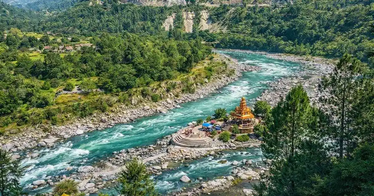
Nandaprayag is one of the Panch Prayag, located at the confluence of the Alaknanda and Nandakini rivers in the Garhwal region of Uttarakhand. This meeting point has long been recognized as a significant geographical and spiritual landmark in the Himalayan river system.

The name Nandaprayag is traditionally associated with local beliefs linked to King Nanda and, in some interpretations, with devotional references to Goddess Nanda. These associations have contributed to its religious identity within regional traditions of the Himalayas.

Historically, Nandaprayag has functioned as a resting and passage point on pilgrimage routes toward higher Himalayan shrines. Its river confluence has remained central to its cultural and spiritual importance for travelers and local communities.

Best Time to Visit Nandaprayag, Uttarakhand

Nandaprayag is most accessible and visually rewarding during stable travel seasons when river confluences are clearly visible and road conditions across the Garhwal region remain dependable for pilgrimage and hill travel.

  • Ideal Months: April to June and September to November are the most suitable periods for visiting, offering reliable road access and clearer views of the Alaknanda–Nandakini confluence.
  • Weather Conditions: These months generally provide comfortable daytime conditions with clear skies, making river viewpoints, temple visits, and highway travel through the region more manageable.
  • Periods to Avoid: July to August should be avoided due to heavy monsoon rainfall, which can cause landslides, road closures, and reduced safety on mountain routes. Mid-winter months can also bring cold conditions that may limit comfort for extended outdoor exploration.

How to Reach Rudraprayag, Uttarakhand

  • By Air: The nearest airport is Jolly Grant Airport in Dehradun, located around 160–180 km from Rudraprayag. It is the main operational airport for the Garhwal region with regular domestic flights. From the airport, taxis and private cabs are available, but the onward journey involves long mountain driving through winding roads.
  • By Train: The nearest railway stations are Rishikesh (around 140 km) and Haridwar (around 160–180 km). These stations are well connected to major Indian cities. After reaching either station, travelers must continue by road via buses, shared jeeps, or taxis, as there is no rail connectivity beyond the plains.
  • By Road: Rudraprayag is located on National Highway 7, forming a key junction on the route to Kedarnath. It is accessible from Rishikesh, Srinagar (Garhwal), Karnaprayag, and Joshimath via regular bus and taxi services. The road route is fully mountainous with sharp curves and variable driving speeds, and travel time may increase significantly during monsoon season due to landslides, fog, or maintenance work. Local travel beyond the town is mainly dependent on shared taxis and jeeps.

What to Expect When You Visit Nandaprayag, Uttarakhand

  • is a small Himalayan confluence town located where the Alaknanda River meets the Nandakini River, surrounded by steep mountain slopes, terraced fields, and tightly clustered hillside settlements.
  • The natural environment is dominated by river valleys, rock-cut terrain, and forested ridges. River flow is strong and the confluence area is the main visual focus, while surrounding areas remain largely residential and agricultural in character.
  • Facilities are basic and functional, with limited guesthouses, small eateries, local shops, and essential services. Visitors should not expect urban-level infrastructure, and availability of premium accommodation or dining is minimal.
  • Movement through the town is constrained by narrow mountain roads and short walking stretches on uneven or inclined paths, especially near river access points and local temple areas. Parking space is limited and often informal.
  • The town primarily serves pilgrims and transit travelers moving between major Char Dham routes, so visitor flow is seasonal and can increase sharply during pilgrimage months, leading to congestion in transport and lodging capacity.
  • Weather conditions can shift quickly, with fog, rainfall, and cold temperatures affecting visibility and road conditions, particularly during monsoon and winter seasons when travel delays are more likely.
  • Overall conditions remain quiet and locally oriented, with daily life centered around river confluence activity, religious stops, and brief halts rather than extended tourist stays or entertainment-driven visits.

Important Visitor Information for Nandaprayag, Uttarakhand

  • Nandaprayag experiences peak crowd levels during the Char Dham Yatra months (May–June and September–October), when pilgrimage traffic increases along the Alaknanda route, while winter months remain comparatively quiet with fewer travelers.
  • Early morning hours offer the most peaceful experience at the confluence of the Alaknanda and Nandakini rivers, with clearer views and minimal vehicular movement, while daytime sees steady transit traffic through the town.
  • Monsoon season (July–August) can bring heavy rainfall, reduced visibility, and landslide risks on connecting mountain roads, often affecting travel time and accessibility in the region.
  • Modest clothing is appropriate when visiting nearby temples and religious points, as Nandaprayag is part of a sacred confluence route frequently used by pilgrims.
  • Visitors should exercise caution near riverbanks due to strong currents and slippery rocks, especially during and after rainfall when water levels in the confluence rise rapidly.
  • Roads around Nandaprayag include steep gradients and sharp bends; cautious driving is essential, and night travel is best avoided during poor weather conditions or low visibility.

Photography and Viewpoints at Nandaprayag, Uttarakhand

  • The primary photography location in Nandaprayag is the confluence point of the Alaknanda and Nandakini rivers, best captured from the main highway bridge where both rivers and the valley settlement can be framed in a single wide shot.
  • Side angles from the approach roads leading into the town provide lower elevation perspectives of the Sangam, allowing layered compositions of river currents, retaining walls, and hillside settlements.
  • Morning hours offer clearer visibility of the river confluence with reduced haze in the narrow Himalayan valley, while late afternoon light highlights the surrounding slopes and adds depth to the river texture.
  • During monsoon season, the rivers become significantly stronger and more turbid, limiting close access but creating high-impact visual contrasts when viewed safely from the bridge and elevated roadside points.
  • Photography near small local temples and residential ghats should be done discreetly, with respect for local religious activity and avoidance of intrusive close-range shooting during rituals.
  • Traffic on NH-7 (Char Dham route) runs close to the main viewpoint areas, and stopping space is limited, so most clear shots are taken quickly from designated pull-offs or the pedestrian sections of the bridge.
  • Peak pilgrimage movement during the Kedarnath Yatra season can restrict uninterrupted framing at the bridge due to continuous vehicle flow and pedestrian congestion.

Near By Attraction

 Temple

Shri Kalpeshwar Temple

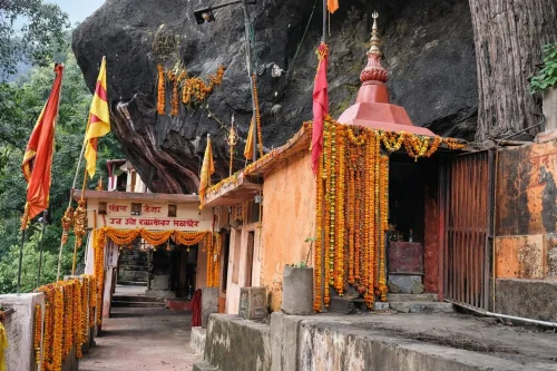
Kalpeshwar Temple is a Hindu temple dedicated to Lord Shiva, located in the Urgam Valley of Chamoli district, Uttarakhand, India.

 Temple

Adi Shankaracharya temple

Adi Shankaracharya Temple is a Hindu temple associated with the philosopher and saint Adi Shankaracharya, located in Jyotirmath (Joshimath), Uttarakhand, India.

Nanda Devi peak rising above dense pine forests in Nanda Devi National Park near Joshimath, a scenic highlight included in Uttarakhand tour packages National Park

Nanda Devi National Park

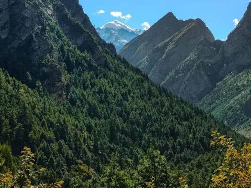
Nanda Devi National Park is a high-altitude protected area located near Joshimath in Chamoli district, Uttarakhand, India.

Frequently Asked Questions About Nandaprayag

Loved this place ? Let’s Plan Your Uttarakhand Trip

Get customized Uttarakhand tour planning designed around seasonal weather changes, hill road travel timing, pilgrimage flow, and comfort-based pacing. Whether you are visiting for spiritual journeys, Himalayan views, wildlife reserves, river valleys, or p

⚡ Quick Response | 💰 Free consultation | 🕒 24×7 expert support

×

Plan Your Trip