Tanglang La Pass: High-Altitude Mountain Pass on Manali-Leh Highway, Ladakh, India

Tanglang La Pass , Tso Moriri
Tourists cross Tanglang La as the final major pass before reaching Leh from the south, marking the descent into the Indus Valley. It is a significant destination for travelers to experience extreme high-altitude conditions and view the distinct, colorful sedimentary rock formations of the Ladakhi mountains and the distant Zanskar range.

Quick Facts About Tanglang La Pass

Entry Fee Free
Timings 06:00 - 18:00
Altitude (m) 5328
Ideal Visit Duration (hrs) 0.25
Best Time of Day Morning
Crowd Level High
Distance from Leh (km) 108
Walking Difficulty Easy
Parking Available Yes
Last Mile Access Road
Suitable for Kids No
Suitable for Seniors No
Wheelchair Friendly No

Why Visit Tanglang La Pass on the Leh-Manali Highway

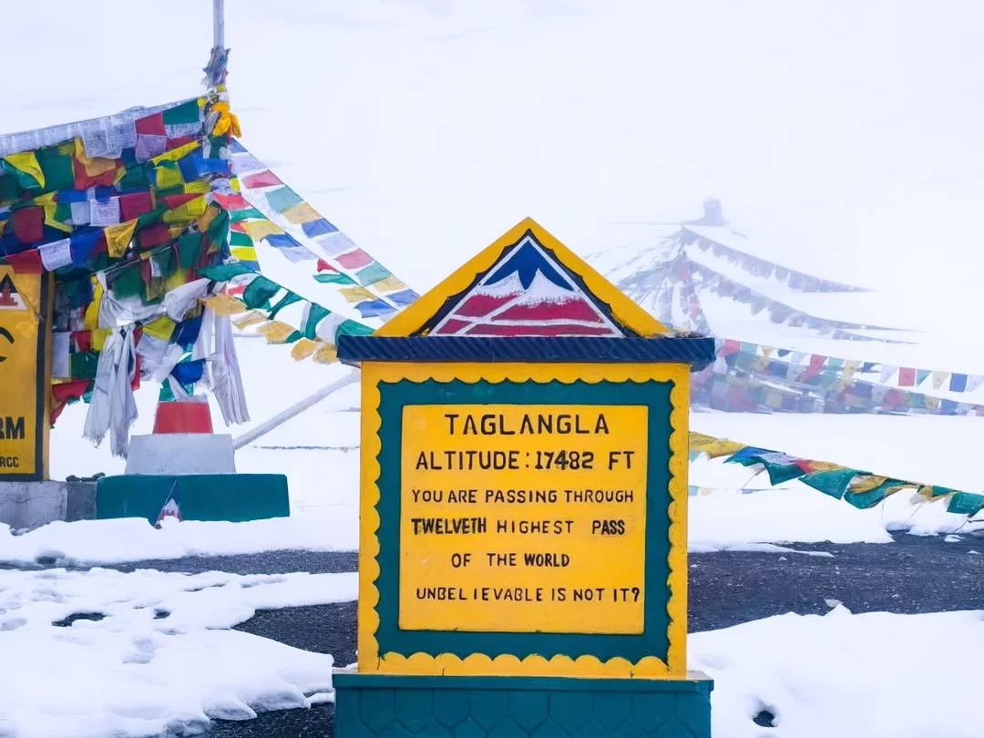
Tanglang La is a high-altitude giant standing at 17,480 feet, serving as the final major mountain crossing for travelers heading toward Leh from the south. It is a bucket-list destination for overlanders and cyclists who wish to conquer what was long considered the second-highest motorable pass in the world, providing a dramatic gateway into the heart of the Indus Valley.

The atmosphere on the pass is one of extreme contrast, where the sheer physical strain of the thin air meets the visual reward of the vast Morey Plains stretching out below. The summit is often draped in fresh snow and heavy clusters of prayer flags, creating a spiritual and triumphant environment that marks the transition from the desolate Rupshu plateau to the irrigated, greener landscapes of central Ladakh.

Tanglang La is distinct for its impressive engineering and the sheer length of its winding switchbacks that cling to the side of the Zanskar Range. Unlike the narrow, rocky tracks of other remote passes, its well-paved surface allows for a unique perspective on the massive geological folding of the Himalayas, offering travelers an unparalleled view of the deep red and purple rock formations that define the region's ancient seabed history.

Historical and Geographic Significance of Tanglang La Pass

Tanglang La is a high-altitude mountain pass situated at an elevation of 5,328 meters (17,480 feet) in the Ladakh region. It is the second-highest motorable pass on the Leh-Manali Highway and serves as the primary gateway into the Indus Valley from the high-altitude plateaus of the south.

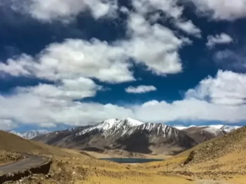
Geographically, the pass is located in the Zanskar Range and acts as a climatic divide between the arid plains of the Morey Plains and the more rugged terrain of the Gya and Upshi valleys. The ascent is characterized by numerous hairpin bends and stark, vegetation-free mountainsides, typical of the Trans-Himalayan rain shadow region.

Historically, Tanglang La has been a critical segment of the ancient trade routes connecting the Indian subcontinent with Tibet and Central Asia. For centuries, it has been used by nomadic Changpa herders to transport salt and wool. Today, the pass is maintained by the Border Roads Organization (BRO) and is a vital logistical artery, though its extreme altitude makes it susceptible to sudden snowstorms even during the summer months.

Best Time to Visit Tanglang La Pass

Tanglang La, soaring at 17,480 feet, is the final major high-altitude hurdle on the Manali-Leh Highway before entering the Indus Valley. As the second-highest motorable pass on this route, its accessibility is strictly governed by the seasonal snow-clearing operations of the Border Roads Organization, offering a brief but spectacular window for trans-Himalayan transit.

  • Ideal months: June to September is the only viable period for travel; September is particularly recommended for its stabilized road conditions and the absence of monsoon-induced slush, providing the clearest views of the Zanskar Range.
  • Weather conditions: Daytime temperatures in summer fluctuate between 5°C and 15°C, but the pass is notorious for sudden, localized snow flurries even in July; oxygen levels are significantly depleted, and relentless winds across the Moore Plains approach can cause rapid dehydration and chill.
  • Periods to avoid: October to May is strictly off-limits as the pass is buried under massive snowdrifts and officially closed to all traffic; additionally, travelers should avoid crossing in late June or during peak August afternoons when heavy snowmelt or monsoon rain can turn the unpaved sections and "Morey Plains" detours into treacherous mud baths.

How to Reach Tanglang La Pass

Tanglang La (or Taglang La), often cited as the world’s second-highest motorable pass at approximately 5,328m (17,480 ft), is a crucial high-altitude crossing on the Leh-Manali Highway (NH3). It acts as the gateway between the vast Moore Plains and the Indus Valley, providing the final major ascent before reaching Leh from the south.

  • Nearest Airport: Kushok Bakula Rimpochee Airport (IXL) in Leh is the closest air link, located about 108 km away. Since the pass is higher than Leh, it is vital to spend at least 48 hours in the city to acclimatize before attempting to drive through Tanglang La.
  • Nearest Railway Station: Jammu Tawi is the most functional railhead, though it is roughly 820 km away. Most tourists prefer flying into Leh or taking the road journey from Manali to reach this sector.
  • Road Access from Leh: The drive from Leh takes approximately 3–4 hours. The route follows the Leh-Manali Highway through Karu, Upshi, and Rumtse. The ascent from the Leh side is generally well-paved but involves numerous steep hairpin bends.
  • Road Access from Manali: If approaching from Manali (approx. 360 km), the pass is reached after crossing the Moore Plains. This direction is more taxing for the body as it involves continuous travel at high altitudes for several days.
  • Last-Mile Connectivity: The pass is accessible via private taxis, self-drive SUVs, and heavy-duty motorcycles. While the BRO maintains the road, the summit stretch can be prone to "black ice" in the early mornings and slush during the peak afternoon snowmelt.
  • Permits and Ecology Fees: While a specific Inner Line Permit (ILP) is not required simply to transit the Leh-Manali Highway, all tourists must pay the Ladakh Ecology Contribution Fee. If you plan to divert toward Tso Kar or Tso Moriri from the pass area, a valid ILP/PAP is mandatory and checked at various points.
  • Realistic Limitations: Due to extreme elevation, oxygen levels are significantly lower than in Leh. Stop durations at the summit should be strictly limited to 10–15 minutes. The pass is seasonally open from June to October; winter closures are absolute due to heavy snow accumulation.

What to Expect When You Visit Tanglang La

  • Environment and Surroundings: At an elevation of 5,328 meters (17,480 feet), Tanglang La is the highest point on the Manali-Leh Highway and the second-highest pass on the route. The summit offers a transition from the narrow gorges of the Zanskar Range to the vast, open Moore Plains. The environment is a freezing, high-altitude desert where oxygen levels are thin and weather conditions can shift from clear skies to heavy snow within minutes.
  • Facilities and Amenities: There are no permanent facilities, shops, or medical centers at the summit. Aside from a small temple and the BRO (Border Roads Organization) altitude marker, the pass is devoid of infrastructure. The nearest basic transit amenities, including seasonal dhabas and tented accommodation, are found approximately 30 kilometers away in Rumtse (Leh side) or Pang (Sarchu side).
  • Accessibility and Movement: The pass is reached via a well-paved section of the NH3, though the road is subject to extreme wear from heavy truck traffic and winter frost. The ascent features numerous long loops that are physically taxing on both vehicles and passengers. Movement can be slow during peak season (June–September) due to slow-moving freight convoys and the occasional road maintenance stop.
  • Typical Visitor Behavior and Conditions: Most travelers stop for only 10–15 minutes to photograph the prayer flags and markers. Prolonged stays are discouraged due to the high risk of Acute Mountain Sickness (AMS), as travelers often ascend quickly from the lower Moore Plains. It is standard for visitors to experience a drop in temperature of 10–15°C compared to the valleys below, and heavy winds are a constant at the ridge.

Essential Visitor Information for Tanglang La Pass

  • Crowd and Weather: As the second-highest motorable pass on the Manali-Leh Highway (5,328 meters/17,480 feet), expect moderate traffic from transit convoys; weather is notoriously volatile with sudden snow flurries and a perpetual, high-velocity wind that creates a severe wind-chill effect even in July.
  • Peak and Quiet Visiting Hours: Peak transit occurs between 11:00 AM and 3:00 PM; for the quietest experience and the most stable light for photography, aim for a crossing between 8:00 AM and 10:00 AM, provided the road has been cleared of overnight frost.
  • Dress Code: Technical cold-weather gear is essential; wear a windproof outer shell, heavy fleece or down mid-layers, and thermal leggings. A woolen cap that covers the ears and a neck buff are necessary to prevent windburn and headaches.
  • Safety and Altitude Cautions: The rapid ascent from the Moore Plains (approx. 4,800m) to the summit often triggers acute altitude symptoms; limit your stay at the top to 10–15 minutes and avoid physical exertion. Descent toward Upshi is steep with numerous hairpins—ensure your vehicle’s brakes are in optimal condition.
  • Logistics and Facilities: There are no permanent shops or medical facilities at the summit; the nearest basic amenities and "tea stalls" are located at the base in Moore Plains or further down in Rumtse. Mobile connectivity is non-existent at the pass.

Strategic Photography and Panoramic Viewpoints at Tanglang La

Tanglang La, situated at an altitude of 5,328 meters (17,480 feet), is the highest point on the Leh-Manali Highway before descending into the Indus Valley. The pass is a premier location for capturing the vast, multi-colored transitions of the Ladakh Range, characterized by deep purples, ochres, and greens of the mineral-rich mountains.

  • The "Gate to Leh" Vista: The most iconic shot is found facing north toward the descent. From the summit, you can capture the road as it zig-zags down into the Gya gorge, offering a dramatic leading line that contrasts the black asphalt against the red sedimentary rock.
  • 360-Degree Himalayan Panorama: Walk approximately 100 meters away from the prayer-flag-heavy summit marker to the ridgeline. This allows for an unobstructed panoramic shot of the Zanskar Range to the south and the distant, snow-capped peaks of the Stok Range to the north.
  • Lighting and Color Saturation: Mid-afternoon (2:00 PM – 4:00 PM) is the peak time for photography here. The lateral light emphasizes the "painted" appearance of the mountainsides, bringing out the vibrant mineral streaks that are often flattened by the vertical midday sun.
  • Atmospheric and Technical Challenges: At over 17,000 feet, the UV levels are extreme. Use a high-quality UV filter and a circular polarizer to maintain sky density and prevent the landscape from looking "washed out" by high-altitude haze.
  • Operational Factors: Tanglang La is a high-traffic zone for heavy trucks and tourist taxis. To avoid "tourist clutter" in your shots, focus your framing on the higher ridges or the distant valley floors. Be prepared for sudden weather shifts; the pass often experiences localized snow squalls even in July, which can provide dramatic, moody lighting if you are safely positioned.

Near By Attraction

Namashang La Pass Ladakh during partly cloudy day, featuring snow-capped peaks turquoise lake valley, winding road barren hills blue sky, perfect scenic adventure Ladakh tour package. Mountain Pass

Namashang La Pass

Namashang La is a high-altitude mountain pass situated at an elevation of approximately 4,960 meters (16,273 feet) in the Leh district of Ladakh.

Pologongka La high-altitude mountain pass BRO signboard fluttering prayer flags barren rugged mountains clear blue skies Ladakh India, scenic offbeat route Tso Moriri Tso Kar Leh-Manali highway adventure travel landmark. Mountain Pass

Pologongka La

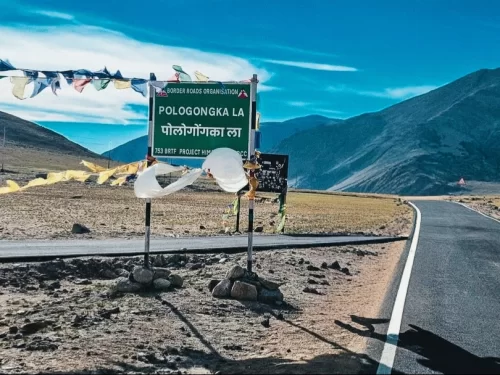
Pologongka La is a mountain pass situated at an elevation of approximately 4,940 meters (16,207 feet) in the Leh district of Ladakh.

Stunning aerial drone view of turquoise Mirpal Tso Lake nestled amid barren rusty brown desert sand dunes rugged arid mountains in remote high-altitude Changthang Ladakh under clear blue skies, perfect India Leh Ladakh offbeat adventure tour package.  Lake

Mirpal Tso

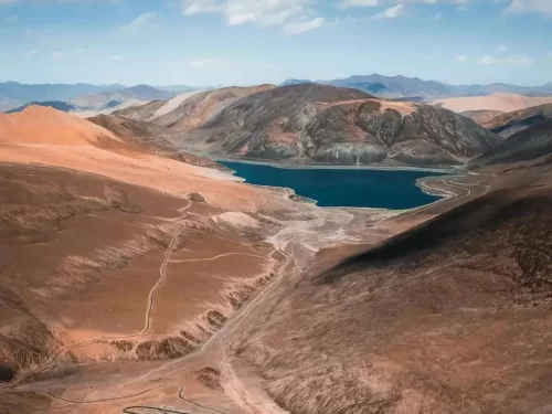
Mirpal Tso is a remote high-altitude freshwater lake situated at an elevation of approximately 4,913 meters (16,122 feet) on the Changthang Plateau.

Frequently Asked Questions About Tanglang La Pass

Tanglang La Pass is located on the Leh Manali Highway in Ladakh between Upshi and Pang. It stands at an altitude of over 17000 feet and is one of the highest motorable passes near Leh city.
Tanglang La Pass can be reached from Leh city by driving approximately 110 kilometers toward the Manali route via Upshi. The journey usually takes three to four hours depending on road and weather conditions.
No separate permit is required specifically for Tanglang La Pass when traveling on the Leh Manali Highway. Travelers should still carry valid identification while journeying from Leh city.
Tanglang La Pass is best visited between June and September when the highway remains open and weather conditions are comparatively stable. Access outside this period depends on snowfall and road clearance updates.
Tanglang La Pass stands at an elevation where oxygen levels are significantly lower than in Leh city. Visitors may experience mild breathlessness due to the thin air at this height.
There are no food stalls or accommodation facilities directly at Tanglang La Pass. Travelers should refuel and arrange meals in Leh city, Upshi, or Pang before crossing the pass.
A regular car in good mechanical condition can reach Tanglang La Pass during the open season as it lies on a national highway. Careful driving is still necessary due to steep gradients and sharp bends.
Travelers usually spend 10 to 15 minutes at Tanglang La Pass because of high altitude and cold winds. Short stops reduce physical strain while allowing time for photographs.
Visitors should wear layered warm clothing and a windproof jacket at Tanglang La Pass. Weather can change quickly and temperatures remain low even in summer.
Tanglang La Pass is generally closed during winter months due to heavy snowfall along the Leh Manali Highway. Travel during colder months depends on official road status updates from Leh city authorities.
Tanglang La Pass can be visited by families who are acclimatized to Ladakh conditions. Senior citizens or young children should avoid long exposure at the summit due to altitude.
Mobile network coverage at Tanglang La Pass is limited or unavailable. Signals are usually available in Leh city and certain highway stretches but not reliably at the summit.

Loved this place ? Let’s Plan Your Ladakh Trip

Get customized Ladakh tour planning designed around altitude comfort, acclimatization time, weather windows, and real Himalayan road conditions. Whether you are visiting for high mountain passes, monasteries, lakes, or remote valley experiences, our exper

⚡ Quick Response | 💰 Free consultation | 🕒 24×7 expert support

×

Plan Your Trip