+91 9910402252
admin@chalbanjare.com
| Entry Fee | Free |
| Timings | 00:00 - 23:59 |
| Altitude (m) | 4960 |
| Ideal Visit Duration (hrs) | 0.25 |
| Best Time of Day | Morning |
| Crowd Level | Low |
| Distance from Leh (km) | 140 |
| Walking Difficulty | Easy |
| Parking Available | Yes |
| Last Mile Access | Road |
| Suitable for Kids | Yes |
| Suitable for Seniors | Yes |
| Wheelchair Friendly | No |
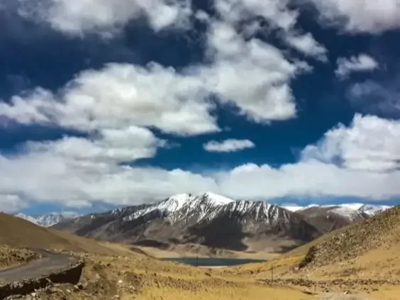
Namashang La is a high-altitude mountain pass situated at approximately 16,300 feet, serving as a vital link between the Indus Valley and the nomadic highlands of Tso Moriri. Travelers ascend this pass to access the remote Rupshu plateau, making it an essential transit point for those seeking to reach the turquoise waters of Korzok and the ancient nomadic settlements of the Changthang.
The atmosphere on the pass is defined by its immense silence and the panoramic views of the surrounding snow-capped peaks of the Zanskar Range. The terrain is a stark, high-desert landscape where the thin air and cold winds emphasize the isolation of the region, yet the sight of colorful prayer flags fluttering at the summit provides a sense of spiritual connection in this vast, barren wilderness.
What makes Namashang La distinct is its role as a gateway to the high-altitude wetlands and the unique biodiversity of the Tso Moriri Ramsar site. It offers travelers a front-row seat to the dramatic geological shifts of the plateau, providing frequent opportunities to spot the Kiang (Tibetan wild ass) and the Himalayan Marmot amidst the rolling plains that lead toward the sacred lake, far from the established tourist circuits.
Namashang La is a high-altitude mountain pass located in the eastern part of Ladakh, situated at an elevation of approximately 4,960 meters (16,273 feet). It serves as a vital transition point on the road between the Indus Valley and the high-altitude lake basins, specifically connecting the Mahe Bridge area to the Tso Moriri wetland reserve.
Geographically, the pass marks the entry into the Korzok sector of the Changthang plateau. The surrounding landscape is characterized by its wide, arid valleys and distant snow-capped peaks of the Zanskar range. Unlike some of the more precipitous passes in western Ladakh, Namashang La features a relatively gradual ascent, making it a critical route for the movement of heavy supplies and logistics to the remote border settlements near the Line of Actual Control (LAC).
Historically, Namashang La has been an indispensable corridor for the Changpa nomads. For generations, these pastoralists have used the pass to move their pashmina goat herds between the winter pastures of the Indus banks and the high-summer grazing lands surrounding the Puga valley and Tso Moriri. Today, the pass is an essential landmark for travelers seeking the geothermal wonders of Puga and the nomadic culture of Korzok, representing a gateway to the deep interior of the Trans-Himalayan wilderness.
Namashang La, standing at an elevation of 16,280 feet, is a vital mountain pass connecting the Puga Valley to the Tso Moriri lake basin. Because it remains part of the high-altitude Changthang plateau, its accessibility is strictly dictated by the heavy winter snowpack and the extreme sub-arctic climate that dominates the region for the majority of the year.
Namashang La Pass is a high-altitude mountain crossing situated at approximately 4,960m (16,273 ft) in the Changthang region of Ladakh. It serves as a vital transit point for travelers moving between the Indus Valley and the high-altitude lake basin of Tso Moriri, offering breathtaking views of the barren Himalayan landscape and the nomadic plains of Kiagar Tso.
Namashang La, standing at an elevation of 4,960 meters (16,273 feet), serves as the scenic gateway to the Tso Moriri wetland sanctuary. Photography at this pass is defined by the sudden, dramatic transition from the high-altitude desert of the Rupshu Plateau to the shimmering blue waters of Tso Kiagar visible in the distance.
 Mountain Pass
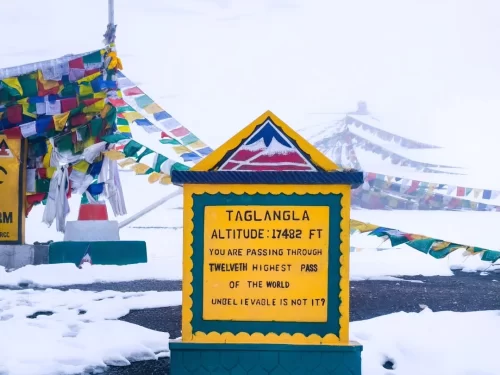
Tanglang La is a high-altitude mountain pass situated at an elevation of approximately 5,328 meters (17,480 feet) in the Ladakh region, often cited as the second-highest motorable pass on the Manali-Leh Highway.
 Mountain Pass
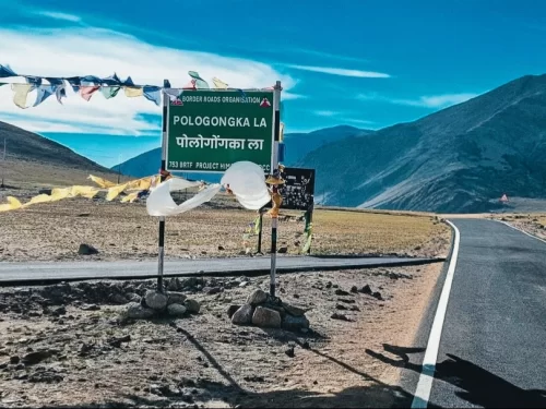
Pologongka La is a mountain pass situated at an elevation of approximately 4,940 meters (16,207 feet) in the Leh district of Ladakh.
 Lake
Lake
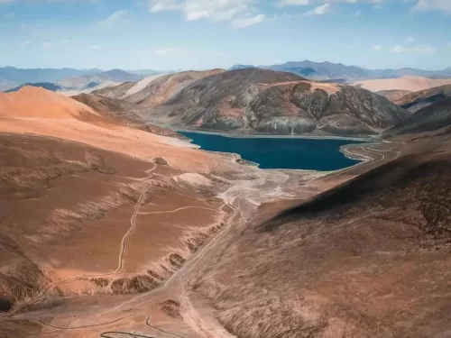
Mirpal Tso is a remote high-altitude freshwater lake situated at an elevation of approximately 4,913 meters (16,122 feet) on the Changthang Plateau.
Get customized Ladakh tour planning designed around altitude comfort, acclimatization time, weather windows, and real Himalayan road conditions. Whether you are visiting for high mountain passes, monasteries, lakes, or remote valley experiences, our exper
⚡ Quick Response | 💰 Free consultation | 🕒 24×7 expert support

