Pologongka La Pass: High-Altitude Mountain Pass in Changthang, Ladakh, India

Pologongka La , Tso Moriri
Tourists traverse Pologongka La primarily while traveling between the Puga Valley and Tso Kar lake, as it serves as a critical link on the route toward the Manali-Leh Highway. The pass is a destination for those interested in geothermal activity and wildlife, providing access to the Puga hot springs and the surrounding high-altitude wetlands known for sightings of the Black-necked Crane.

Quick Facts About Pologongka La

Entry Fee Free
Timings 06:00 - 18:00
Altitude (m) 5883
Ideal Visit Duration (hrs) 0.1
Best Time of Day Morning
Crowd Level Low
Distance from Hanle (km) 105
Walking Difficulty Very High
Parking Available Yes
Last Mile Access Road
Suitable for Kids No
Suitable for Seniors No
Wheelchair Friendly No

Why Visit Pologongka La Pass in Ladakh

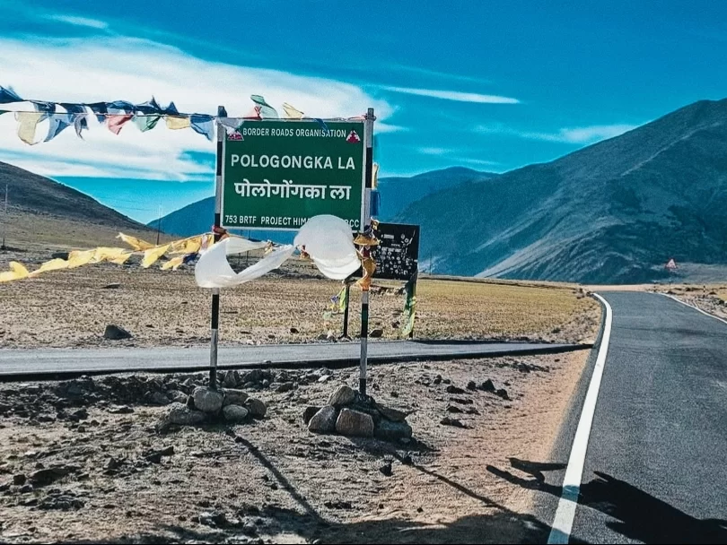
Pologongka La is a high-altitude mountain pass standing at approximately 16,330 feet, primarily visited by travelers transitioning between the turquoise waters of Tso Kar and the remote Puga Valley. It serves as a vital link for those exploring the Rupshu plateau, offering an essential route for overland expeditions seeking to witness the unique geothermal and salt-lake ecosystems of the Changthang region.

The atmosphere on the pass is defined by its proximity to the Puga geothermal fields, where the air is often filled with a distinct sulfurous scent and the sight of rising steam plumes from nearby hot springs. The environment is stark and windswept, featuring a vast, rolling landscape of golden-brown earth that provides a quiet, meditative space away from the more crowded transit routes of central Ladakh.

What makes Pologongka La distinct is its role as a vantage point for observing the rare convergence of Ladakh’s geothermal activity and its ancient salt-crusted basins. It offers travelers a front-row seat to the geological diversity of the region, from the white saline borders of Tso Kar to the bubbling borax springs of Puga, making it a premier location for those interested in high-altitude geology and the unique wildlife, such as the Kiang (Tibetan wild ass), that inhabits these mineral-rich plains.

Historical and Geographic Significance of Pologongka La Pass

Pologongka La is a high-altitude mountain pass situated at an elevation of approximately 4,940 meters (16,207 feet) in the Ladakh region of India. It serves as a vital geographic link between the Tso Moriri lake basin and the Puga Valley, which is renowned for its geothermal activity and hot springs.

The pass is located within the Changthang Wildlife Sanctuary, a high-plateau ecosystem that supports rare Trans-Himalayan fauna. Historically, Pologongka La has been an essential route for the Changpa nomads, facilitating the movement of livestock between the salt-rich plains of Tsokar and the summer pastures surrounding Tso Moriri.

Geologically, the area around the pass is significant due to its proximity to the Puga geothermal field, where tectonic activity manifests in sulfur deposits and borax springs. Today, the pass is primarily used by travelers navigating the circuit between Leh and the high-altitude lakes of eastern Ladakh, offering a less-frequented alternative to the main highway routes.

Best Time to Visit Pologongka La Pass

Pologongka La, sitting at an elevation of approximately 16,330 feet, is a critical high-altitude pass connecting the Tso Kar basin with the Puga Valley and the broader Changthang plateau. Its accessibility is dictated by the extreme weather patterns of the Rupshu plains, making it a seasonal route primarily used by travelers moving between Leh and the Tso Moriri circuit.

  • Ideal months: June to September is the optimal window for travel, with the late summer months of August and September providing the driest and most reliable road surfaces across the sandy plateau.
  • Weather conditions: Summer days are characterized by thin, crisp air and piercing sunlight with temperatures reaching 12°C to 15°C, but the pass is highly susceptible to the "Changthang winds"—powerful, dust-laden gusts that significantly lower the perceived temperature and can cause visibility issues.
  • Periods to avoid: November to April is impassable for standard vehicles due to heavy snow accumulation and temperatures that regularly plummet below -30°C; additionally, early June can be tricky as the melting permafrost can turn the approach tracks into soft, unstable mud traps.

How to Reach Pologongka La Pass

Pologongka La, situated at an elevation of approximately 4,940m (16,207 ft), is a significant mountain pass in the Ladakh region that serves as the gateway to the remote and stunning Tso Kar lake basin. It is an essential transit point for those traveling between the Mahe bridge and the Moore Plains on the Leh-Manali Highway.

  • Nearest Airport: Kushok Bakula Rimpochee Airport (IXL) in Leh is the closest airport, roughly 145 km away via the Chumathang route. Travelers should ensure they are well-acclimatized in Leh for at least 2–3 days before heading toward this high-altitude zone.
  • Nearest Railway Station: Jammu Tawi is the nearest major railhead, located over 750 km away. Practical access is limited to road expeditions starting from either Leh or Manali.
  • Road Access and Routes: The pass is most commonly accessed via the Leh – Upshi – Chumathang – Mahe route. At Mahe, the road diverts toward the Puga Valley and Tso Kar. Alternatively, it can be reached from the Manali-Leh Highway by turning off at the Moore Plains toward Tso Kar and then climbing toward the pass.
  • Last-Mile Connectivity: There is no public transportation available to the pass. Travel is conducted via private 4x4 SUVs, taxis, or heavy-duty motorcycles. The road is maintained by the BRO but can be rough, with sections of loose gravel and sand, especially near the Puga geothermal springs area.
  • Permits and Regulations: Accessing Pologongka La requires a valid Inner Line Permit (ILP) for Indian citizens or a Protected Area Permit (PAP) for foreigners, as it lies within the restricted Changthang Wildlife Sanctuary. Permits are checked at the Mahe Bridge or near Tso Kar.
  • Travel Conditions and Hazards: The pass is typically accessible from June to October. The area is known for its high-altitude desert climate and extreme winds. While the ascent is not as steep as some other passes, the remote nature means there is no mobile network or mechanical support. The nearest basic facilities are in Chumathang or the small nomadic settlements near Tso Kar.

What to Expect When You Visit Pologongka La

  • Environment and Surroundings: At an altitude of approximately 4,940 meters (16,207 feet), the pass provides a high-altitude gateway between the Tso Kar basin and the Puga Valley. The landscape is a classic Changthang cold desert, featuring expansive sandy plateaus, rolling brown hills, and unique geothermal activity visible in the distance from nearby Puga. The area is exceptionally windy, with grit-laden gusts being a constant factor at the summit.
  • Facilities and Amenities: There is zero infrastructure at the pass. No shops, restrooms, or emergency shelters exist. The summit is marked only by Buddhist prayer flags and a basic road sign. Visitors must be self-reliant; the nearest very basic amenities are located in the nomadic summer settlements near Tso Kar or the remote village of Sumdo, both of which lack professional medical or mechanical support.
  • Accessibility and Movement: The road connecting Tso Kar to the Puga Valley was traditionally a rough, sandy track but has seen recent surfacing improvements. However, it remains a remote mountain route prone to shifting sands and seasonal snow blockages. High-clearance vehicles are strongly recommended due to the potential for steep gradients and loose surface material. An Inner Line Permit (ILP) is required for all travelers exploring this sector of eastern Ladakh.
  • Typical Visitor Behavior and Conditions: Most travelers use Pologongka La as a transit point when traveling between Tso Moriri and the Leh-Manali Highway. Due to the high elevation and lack of oxygen, stops are usually limited to 5–10 minutes for photography. It is common to spot high-altitude wildlife such as Kiang (Tibetan wild ass) in the plains below the pass. Visitors are advised to move slowly to avoid the immediate effects of hypoxia, as the ascent from the surrounding basins is relatively quick.

Essential Visitor Information for Pologongka La Pass

  • Crowd and Weather: Located at 4,940 meters (16,207 feet) on the route between Tso Kar and Puga Valley, this pass is extremely quiet and often overlooked; the weather is characterized by intense, dry cold and relentless winds that sweep across the Rupshu plateau.
  • Peak and Quiet Visiting Hours: Most travelers cross between 10:00 AM and 2:00 PM; visiting during the early morning provides the clearest views of the surrounding salt-crusted landscapes, but be prepared for frozen ground and sub-zero wind chills.
  • Dress Code: Heavy wind-blocking layers are essential; wear a high-fill down jacket over thermal layers, a fleece neck gaiter, and polarized sunglasses to protect against the high-altitude glare reflecting off the nearby saline basins.
  • Safety and Practical Cautions: While the ascent is gradual compared to other passes, the sustained high altitude of the Rupshu region means Acute Mountain Sickness (AMS) remains a constant threat; limit your stay at the summit to 15 minutes and stay hydrated with electrolytes.
  • Terrain and Logistics: The road is often a mix of broken tarmac and sandy tracks; ensure your vehicle is capable of handling soft sand patches, and carry sufficient water as there are no settlements or commercial facilities between the Tso Kar basin and the Puga geothermal area.

Capturing the High-Altitude Wetland Vistas of Pologongka La

Rising to approximately 4,940 meters (16,207 feet), Pologongka La serves as a critical geographic transition between the freshwater Startsapuk Tso and the vast, saline Tso Kar wetland complex. Photography at this pass is characterized by expansive views of the Rupshu Plateau’s unique basin, where mineral-streaked mountains meet vibrant alpine lakes.

  • Startsapuk Tso Panorama: The descent from the pass toward Tso Kar offers the most comprehensive view of Startsapuk Tso. From the upper switchbacks, use a wide-angle lens to capture the lake’s turquoise waters framed by the stark, white salt crusts that define the edge of the Tso Kar basin.
  • The Pologongka Massif: To the north of the pass lies the Pologongka Range, featuring peaks exceeding 6,000 meters. The "Moonscape" textures of these barren slopes are best captured using a telephoto lens to compress the layers of sedimentary rock and high-altitude scree against the deep indigo sky.
  • Optimal Lighting for Saline Contrast: Arrive between 9:00 AM and 11:00 AM to capture the high-contrast "white-on-blue" effect of the salt flats. Early morning light provides a softer glow on the surrounding mountains, but the mid-morning sun is necessary to make the mineral deposits on the lake shores pop visually.
  • Dust and Equipment Protection: The Tso Kar basin is notoriously dusty due to fine salt and silt particles. Avoid changing lenses at the summit or during the descent, as high winds can instantly coat your sensor. Use a protective filter to shield your glass from wind-borne grit.
  • Wildlife Photography Opportunities: The area around Pologongka La is a prime habitat for the Kiang (Tibetan Wild Ass) and rare birds like the Black-necked Crane. Keep a long lens (400mm+) ready for spontaneous sightings along the plateau stretches immediately following the pass descent.
  • Photography Restrictions: While there are no specific military bans at this pass compared to border zones like Umling La, the Tso Kar area is a protected Ramsar wetland site. Maintain a respectful distance from nesting birds and do not venture off-road with vehicles for "better angles," as the crusty soil is ecologically fragile.

Near By Attraction

Namashang La Pass Ladakh during partly cloudy day, featuring snow-capped peaks turquoise lake valley, winding road barren hills blue sky, perfect scenic adventure Ladakh tour package. Mountain Pass

Namashang La Pass

Namashang La is a high-altitude mountain pass situated at an elevation of approximately 4,960 meters (16,273 feet) in the Leh district of Ladakh.

Tanglang La (Taglang La) Pass sits at 5,328 meters (17,480 ft) on Leh-Manali Highway in Ladakh, often signposted as 17,582 ft and claimed as second highest motorable pass after Khardung La, though now ranked around 12th globally Mountain Pass

Tanglang La Pass

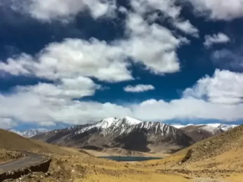
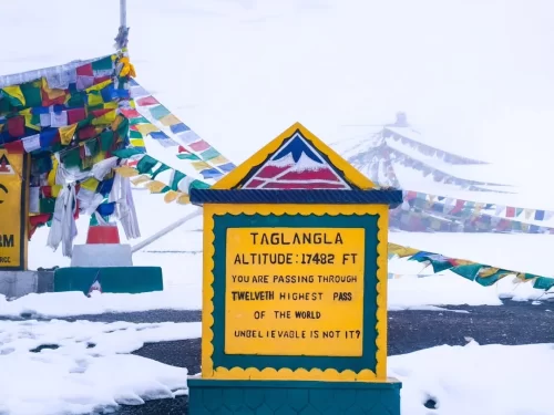
Tanglang La is a high-altitude mountain pass situated at an elevation of approximately 5,328 meters (17,480 feet) in the Ladakh region, often cited as the second-highest motorable pass on the Manali-Leh Highway.

Stunning aerial drone view of turquoise Mirpal Tso Lake nestled amid barren rusty brown desert sand dunes rugged arid mountains in remote high-altitude Changthang Ladakh under clear blue skies, perfect India Leh Ladakh offbeat adventure tour package.  Lake

Mirpal Tso

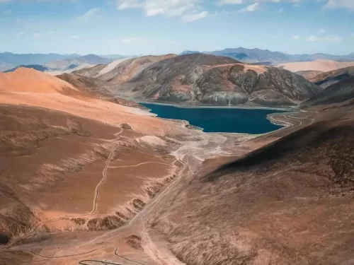
Mirpal Tso is a remote high-altitude freshwater lake situated at an elevation of approximately 4,913 meters (16,122 feet) on the Changthang Plateau.

Frequently Asked Questions About Pologongka La

Pologongka La is a high altitude mountain pass located in the Changthang region of eastern Ladakh between Tso Moriri and Tso Kar. It lies southeast of Leh city along interior plateau routes of the Union Territory of Ladakh.
Pologongka La can be reached from Leh city by driving via Upshi and Chumathang toward Tso Moriri or by approaching from the Tso Kar side. The journey usually takes a full day because of distance and high altitude terrain.
An Inner Line Permit is required for tourists visiting Pologongka La since the pass falls within a restricted area of Ladakh. Permits must be obtained in Leh city before starting the trip.
The best time to visit Pologongka La in Ladakh is between June and September when mountain tracks are generally clear and weather conditions are more predictable. Access outside this period depends on snow and road clearance.
Pologongka La stands at an elevation of around 16300 feet where oxygen levels are noticeably lower than in Leh city. Visitors may feel breathless or fatigued if they have not acclimatized properly.
There are no food stalls, fuel stations, or accommodation facilities at Pologongka La. Travelers should carry drinking water and essential supplies and plan overnight stays near Tso Moriri or Tso Kar instead.
A high clearance SUV is recommended for reaching Pologongka La due to rough gravel tracks and sandy stretches. Vehicles should be in strong mechanical condition for remote high altitude travel.
Travelers usually spend 10 to 20 minutes at Pologongka La because of altitude and wind exposure. Short visits allow time for photographs while reducing physical strain.
Visitors should wear layered thermal clothing and a windproof jacket when visiting Pologongka La. Even during summer months temperatures can drop quickly with strong winds.
Pologongka La is generally not accessible during winter months as snowfall and extreme cold block interior plateau roads in Ladakh. Travel plans depend on seasonal updates from Leh city authorities.
Pologongka La is better suited for acclimatized and physically fit travelers. Senior citizens or young children should consider altitude sensitivity before planning this route from Leh city.
Mobile network connectivity is not available at Pologongka La in Ladakh. Signals are typically lost well before reaching the pass, so communication should be arranged in advance from Leh city.

Loved this place ? Let’s Plan Your Ladakh Trip

Get customized Ladakh tour planning designed around altitude comfort, acclimatization time, weather windows, and real Himalayan road conditions. Whether you are visiting for high mountain passes, monasteries, lakes, or remote valley experiences, our exper

⚑ Quick Response | πŸ’° Free consultation | πŸ•’ 24Γ—7 expert support

×

Plan Your Trip