Mirpal Tso: High-Altitude Freshwater Lake in Chushul, Ladakh, India

Mirpal Tso , Tso Moriri
Tourists visit Mirpal Tso for its extreme seclusion and pristine turquoise waters, often stopping here while traversing the rugged route between Chushul and the Kaksang La pass. The lake is a significant site for off-road explorers and photographers due to its sandy shores, surrounding barren mountain landscapes, and sightings of rare high-altitude wildlife such as the Black-necked Crane and Kiang (Tibetan Wild Ass)

Quick Facts About Mirpal Tso

Entry Fee Free
Timings 06:00 - 18:00
Altitude (m) 4900
Ideal Visit Duration (hrs) 0.5
Best Time of Day Morning
Crowd Level Low
Distance from Leh (km) 150
Walking Difficulty Easy
Parking Available Yes
Last Mile Access Road
Suitable for Kids No
Suitable for Seniors No
Wheelchair Friendly No

Why Visit Mirpal Tso in Ladakh

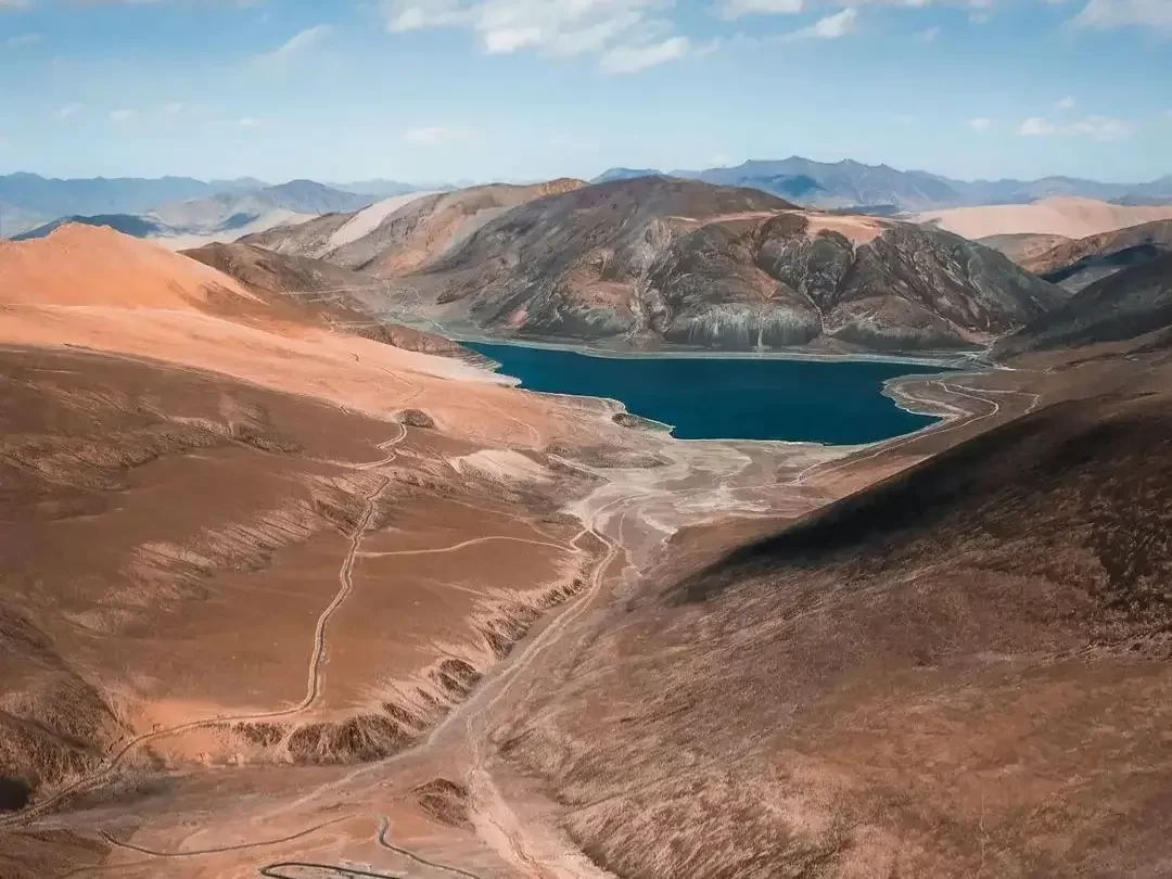
Mirpal Tso is a hidden high-altitude lake located in the remote Chushul-Nyoma sector, attracting intrepid travelers who wish to explore the frontier landscapes of the Changthang. It serves as a pristine stop for those traversing the rugged back-country routes between Hanle and the Pangong Tso region, offering a level of solitude that is increasingly rare in Ladakh’s more famous lake basins.

The on-ground atmosphere is defined by a sense of extreme seclusion and raw wilderness, with the lake’s sapphire waters often reflecting the sharp, snow-dusted peaks of the surrounding ranges. Visitors find a landscape devoid of any permanent structures or commercial activity, where the silence is only broken by the sound of the wind across the high-altitude desert and the occasional presence of nomadic herders moving through the vast grazing grounds.

Mirpal Tso is distinct for its brackish water composition and the dramatic contrast between its vivid blue hues and the sun-bleached, golden-brown shorelines. Its location near the Kakasang La and Hor La passes makes it a significant waypoint for high-clearance overland expeditions, providing a unique vantage point to experience the untouched biodiversity and the sheer geological scale of the Indo-China borderlands.

Historical and Geographic Significance of Mirpal Lake

Mirpal Lake is a high-altitude freshwater lake situated in the remote Changthang region of Ladakh, located near the village of Chushul. Positioned at an elevation of approximately 4,850 meters (15,912 feet), the lake serves as a critical alpine wetland within the Trans-Himalayan ecosystem, providing a vital water source for local wildlife and migratory bird species.

Geographically, Mirpal Lake is nestled between the rugged peaks of the Pangong range and the expansive plateau leading toward the Line of Actual Control (LAC). Its location makes it strategically significant and requires specific military permits for civilian access, as it lies within a sensitive border zone that saw historical activity during the 1962 Sino-Indian War.

The lake is an essential resource for the nomadic Changpa community, who utilize the surrounding pastures for grazing their pashmina goats during the summer months. Unlike the more famous saline lakes of Ladakh, Mirpal Lake is known for its clear, blue freshwater and remains largely untouched by commercial tourism, preserving its pristine natural state and local ecological importance.

Best Time to Visit Yaye Tso

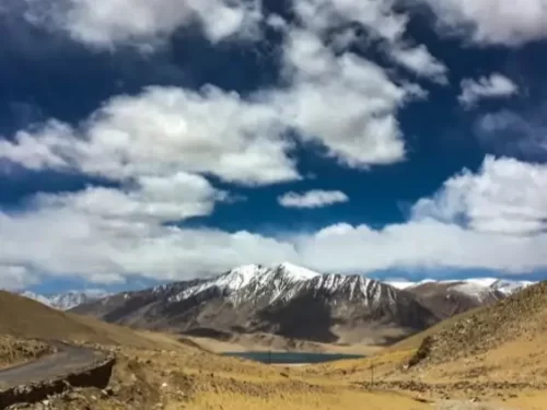
Yaye Tso, a stunning volcanic lake located near the village of Mahe in Ladakh, is a high-altitude destination that requires careful timing to appreciate its deep blue waters and surrounding crater-like geography. At nearly 16,000 feet, the lake is frozen for much of the year, making the short summer window the only time to witness its unique geological features and vibrant colors.

  • Ideal months: June to September is the optimal period, with July and August offering the best chance to see the lake completely thawed and reflecting the surrounding peaks.
  • Weather conditions: Daytime conditions during summer are usually clear with intense solar radiation, but the area is notorious for high-velocity winds that sweep across the open plateau; temperatures can drop from a pleasant 15°C in the sun to near 0°C immediately after sunset.
  • Periods to avoid: Avoid visiting from November to April when the lake is a solid sheet of ice and the trail/road access from Mahe or Chumathang can be blocked by heavy snow; the winter months also bring extreme temperatures reaching -25°C, making the high-altitude stay in nearby homestays extremely challenging for most tourists.

How to Reach Yaye Tso

Yaye Tso is a high-altitude volcanic lake located at approximately 4,960m in the Changthang region of Ladakh. Known for its distinct blue waters and proximity to the village of Mahe, it is a remote destination that requires specific planning for access and permits.

  • Nearest Airport: Kushok Bakula Rimpochee Airport (IXL) in Leh is the closest airport, roughly 180 km away. Travelers must undergo at least two days of mandatory acclimatization in Leh before heading toward the higher elevations of the lake.
  • Nearest Railway Station: Jammu Tawi is the nearest major railhead, located over 800 km away. Due to the terrain, flying into Leh or driving from Manali is the only practical way to reach the region.
  • Road Access: The lake is reached via the Leh – Karu – Upshi – Chumathang – Mahe route. From the Mahe Bridge checkpoint, a diversion leads toward the lake. The road from Leh to Mahe is largely paved, but the final approach to Yaye Tso involves navigating narrow, unpaved mountain tracks.
  • Last-Mile Connectivity: There is no public transport to Yaye Tso. Visitors must hire a private 4x4 SUV or use an adventure motorcycle from Leh. The climb from Mahe is steep and requires a vehicle in excellent mechanical condition.
  • Permits and Restrictions: Being in a sensitive border zone, an Inner Line Permit (ILP) is mandatory for Indian tourists, and a Protected Area Permit (PAP) is required for foreigners. These must be obtained in Leh, and original copies must be produced at the Mahe Bridge check-post.
  • Realistic Conditions: The lake remains frozen during winter and is typically accessible from late May to September. There are no tourist facilities, shops, or petrol pumps at the lake; the nearest basic amenities and fuel are found in Chumathang or Nyoma.

What to Expect When You Visit Yaye Tso

  • Environment and Surroundings: Yaye Tso is a high-altitude volcanic lake situated at approximately 4,986 meters (16,358 feet). It is characterized by its deep blue waters set within a stark, crater-like basin surrounded by barren, rolling brown hills. The area is extremely tranquil and less frequented than other Ladakhi lakes, offering a raw, silent wilderness experience with significant exposure to high-velocity winds.
  • Facilities and Amenities: There are no tourist facilities, guesthouses, or eateries at the lake. The site is entirely undeveloped with no shops, public toilets, or medical services. Visitors must carry their own food and water, with the closest basic homestays located in the remote village of Mahe or further away in Chumathang.
  • Accessibility and Movement: Access requires a detour from the Mahe-Puga stretch, involving travel over rough, unpaved tracks that demand a high-clearance 4x4 vehicle. The terrain is sensitive and navigation can be difficult due to a lack of clear signage. A valid Inner Line Permit (ILP) is mandatory for all visitors as the lake is located in a restricted border zone.
  • Typical Visitor Behavior and Conditions: Due to its extreme altitude and the steep climb required to reach the viewing points, visitors often experience rapid onset of breathlessness. The lake is primarily a photography and bird-watching stop; however, visitors must practice "Leave No Trace" principles strictly, as there is no waste management. Most travelers spend less than 30 minutes at the site due to the lack of oxygen and shelter.

Essential Visitor Information for Yaye Tso

  • Crowd and Weather: Yaye Tso is a secluded high-altitude lake with virtually zero tourist crowds; the weather is dominated by intense solar radiation during the day and piercing, high-velocity winds that can cause temperatures to feel sub-zero even in peak summer.
  • Peak and Quiet Visiting Hours: Best visited between 11:00 AM and 2:00 PM when the sun is directly overhead to see the vibrant turquoise hues; avoid visiting after 4:00 PM as the lack of settlements and plummeting temperatures make the remote return journey to Mahe or Nyoma hazardous.
  • Dress Code: Heavy-duty windbreakers or down jackets are required regardless of the month; wear polarized sunglasses to protect against the high UV index and "snow blindness" effects from the lake's reflection, and carry a buff or face mask to shield against dust and windburn.
  • Safety and Practical Cautions: At an elevation of approximately 4,820 meters (15,814 feet), Yaye Tso is higher than Pangong Tso; limit your stay to 20 minutes to prevent altitude-induced hypoxia and ensure you have an Inner Line Permit (ILP) specifically covering the Chushul-Mahe circuit.
  • Logistics and Terrain: There are no facilities, food stalls, or mobile networks within a 20km radius; the access road via Hor La involves steep gradients and loose gravel, necessitating a 4x4 vehicle or high-clearance SUV and a full tank of fuel.

Photography Strategy and Viewpoints for Yaye Tso (The Heart Lake)

Yaye Tso is a rare, volcanic high-altitude lake situated at approximately 4,820 meters (15,814 feet) along the remote Chushul–Mahe route. Known for its distinct heart-like shape when viewed from the surrounding ridges, it offers a stark, sapphire-blue contrast against the copper-toned volcanic soil of the Changthang Plateau.

  • The "Heart" Vantage Point: The definitive shot of Yaye Tso is captured from the descent of the Hor La Pass. As you approach from Kaksang La, pull over at the high-altitude ridgeline before the road drops toward the shore. From this elevated angle, the lake’s unique heart-shaped perimeter is perfectly visible against the barren valley floor.
  • Shoreline Composition: For ground-level shots, the western bank offers the best foreground interest, featuring small volcanic rocks and occasional patches of alpine moss. Use a wide-angle lens (16-24mm) to include these textures while capturing the reflection of the surrounding 6,000-meter peaks in the still, crystal-clear water.
  • Lighting and Color Shifts: The lake is a "chameleon" depending on the sky. Under direct midday sun, the water turns a brilliant, saturated turquoise. For professional depth, visit between 10:00 AM and 1:00 PM; unlike other Ladakh locations, the high-altitude clarity here makes the midday sun less "flat" and more effective at penetrating the water's surface to reveal its deep blue hues.
  • Extreme Environmental Factors: The wind at Yaye Tso is notoriously relentless and can destabilize gear. If using a tripod for long exposures or time-lapses, ensure it is low-profile or weighted. Due to the fine volcanic dust, avoid changing lenses near the lake shore to prevent sensor contamination.
  • Permits and Restrictions: Yaye Tso is located in a highly sensitive border zone near the LAC. While landscape photography is permitted, it is strictly forbidden to point cameras toward any military installations or convoys. Drones are generally prohibited in the Chushul sector due to military proximity and the absence of civilian flight clearance.

Near By Attraction

Namashang La Pass Ladakh during partly cloudy day, featuring snow-capped peaks turquoise lake valley, winding road barren hills blue sky, perfect scenic adventure Ladakh tour package. Mountain Pass

Namashang La Pass

Namashang La is a high-altitude mountain pass situated at an elevation of approximately 4,960 meters (16,273 feet) in the Leh district of Ladakh.

Tanglang La (Taglang La) Pass sits at 5,328 meters (17,480 ft) on Leh-Manali Highway in Ladakh, often signposted as 17,582 ft and claimed as second highest motorable pass after Khardung La, though now ranked around 12th globally Mountain Pass

Tanglang La Pass

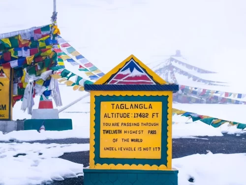
Tanglang La is a high-altitude mountain pass situated at an elevation of approximately 5,328 meters (17,480 feet) in the Ladakh region, often cited as the second-highest motorable pass on the Manali-Leh Highway.

Pologongka La high-altitude mountain pass BRO signboard fluttering prayer flags barren rugged mountains clear blue skies Ladakh India, scenic offbeat route Tso Moriri Tso Kar Leh-Manali highway adventure travel landmark. Mountain Pass

Pologongka La

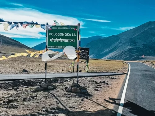
Pologongka La is a mountain pass situated at an elevation of approximately 4,940 meters (16,207 feet) in the Leh district of Ladakh.

Frequently Asked Questions About Mirpal Tso

Mirpal Tso is a high altitude lake located in the Changthang region of Ladakh near the Chushul sector. It lies between Chushul and Kaksang La in a remote border area southeast of Leh city.
Mirpal Tso can be reached from Leh city by driving via Chang La and continuing toward the Chushul sector. The journey covers long high altitude stretches and usually takes a full day due to terrain and checkpoints.
An Inner Line Permit is required for tourists visiting Mirpal Tso because the lake is situated in a restricted border zone of Ladakh. Permits are issued in Leh city before travel.
The best time to visit Mirpal Tso in Ladakh is from June to September when mountain passes are open and road access is comparatively stable. Outside this period snow and extreme weather can affect travel plans.
Mirpal Tso is located at an altitude of around 16000 feet where oxygen levels are considerably lower than in Leh city. Visitors may experience breathlessness if they have not acclimatized properly.
There are no food outlets or accommodation facilities at Mirpal Tso. Travelers must carry water, snacks, and essential supplies from Leh city or from settlements along the route.
A high clearance SUV is generally recommended to reach Mirpal Tso due to rough and unpaved tracks in the interior Changthang region. The route involves gravel roads and uneven sections that require careful driving.
Travelers typically spend 15 to 30 minutes at Mirpal Tso because of the high altitude and strong winds. Short visits help reduce physical strain while allowing time to view the lake.
Visitors should wear layered thermal clothing and carry windproof outerwear when visiting Mirpal Tso. Weather conditions can change quickly and temperatures remain low even during summer months.
Mirpal Tso is usually not accessible during winter months as snowfall and extreme cold block high mountain routes. Access depends entirely on seasonal road conditions in Ladakh.
Mirpal Tso is better suited for physically fit travelers who are accustomed to high altitude journeys. Senior citizens or young children should consider altitude sensitivity before planning the visit from Leh city.
Mobile network connectivity is generally unavailable at Mirpal Tso in Ladakh. Signals are usually lost after crossing key checkpoints, so travelers should plan communication before leaving Leh city.

Loved this place ? Let’s Plan Your Ladakh Trip

Get customized Ladakh tour planning designed around altitude comfort, acclimatization time, weather windows, and real Himalayan road conditions. Whether you are visiting for high mountain passes, monasteries, lakes, or remote valley experiences, our exper

⚑ Quick Response | πŸ’° Free consultation | πŸ•’ 24Γ—7 expert support

×

Plan Your Trip