Puga Valley – Geothermal Hot Springs & Steam-Filled Landscapes

Puga Valley , Tso Moriri
Puga Valley lies in southeastern Ladakh at high elevation, offering stark landscapes shaped by volcanic activity and dotted with natural hot springs. It is quieter and less visited than central Ladakh sights, attracting travelers interested in geology, photography, and off-beat routes. Access involves long drives on challenging roads, and services around the valley are limited, so preparation and local guidance are important.

Quick Facts About Puga Valley

Entry Fee Free
Timings 06:00 - 18:00
Altitude (m) 4400
Ideal Visit Duration (hrs) 1
Best Time of Day Morning
Crowd Level Low
Distance from Leh (km) 170
Walking Difficulty Moderate
Parking Available No
Last Mile Access Road
Suitable for Kids No
Suitable for Seniors No
Wheelchair Friendly No

Quick Facts About Puga Valley

Entry Fee No entry fee
Timings Open throughout the day; best visited during daylight hours
Altitude (m) Approximately 4400 meters above sea level
Ideal Visit Duration 30 to 60 minutes
Best Time of Day Late morning to early afternoon for visibility and warmth
Crowd Level Low; mostly visited by offbeat travelers and photographers
Distance from City Centre (km) Approximately 170 km from Leh town
Walking Difficulty Easy to moderate; uneven and marshy ground in some sections
Parking Available Informal roadside parking available near viewing areas
Last Mile Access Motorable road; final stretch may be rough depending on weather
Suitable for Kids Limited; high altitude and lack of facilities require caution
Suitable for Seniors Not recommended unless well acclimatized and medically fit
Wheelchair Friendly No; uneven terrain and lack of infrastructure

Geological Background of Puga Valley

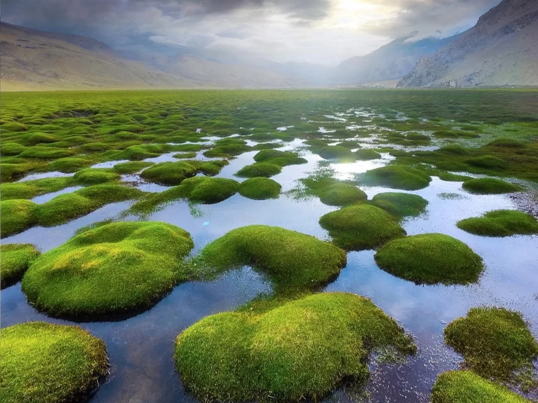
Puga Valley does not have a recorded human or dynastic history in the conventional sense. Its significance comes from geology rather than settlements, monuments, or religious traditions. The valley lies within an active geothermal zone formed by tectonic activity along the Indian and Eurasian plate boundary, which defines much of Ladakh’s landscape.

For decades, Puga Valley has been studied by geologists and energy researchers due to its visible geothermal features such as steaming ground, sulfur deposits, and hot springs. During the late 20th century, the area was identified as one of India’s most promising sites for geothermal energy potential, leading to scientific surveys and pilot studies rather than tourism-driven development.

Local pastoral communities historically used the valley only seasonally, mainly for grazing livestock, as the harsh climate, marshy terrain, and lack of fresh water made permanent habitation impractical. Even today, the area remains largely untouched by construction, preserving its raw, natural state.

Puga Valley’s importance today is scientific and environmental rather than cultural. It represents a rare natural laboratory where visitors can observe geothermal processes in an open Himalayan landscape, making it valuable for education, research, and responsible offbeat travel.

Best Time to Visit Puga Valley

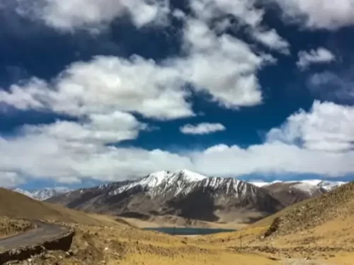
The best time to visit Puga Valley is from late May to early October, when high-altitude roads in eastern Ladakh are generally accessible and weather conditions are relatively stable. During this period, daytime temperatures allow short outdoor exploration without prolonged exposure to extreme cold, and visibility is usually clear enough to observe the valley’s geothermal features.

June to September is considered the most practical window for most travelers. Snow has melted from approach roads, and river crossings along the route are manageable. However, even in peak summer, Puga Valley remains cold and windy due to its elevation, and sudden weather changes are common.

October marks the start of rapid temperature drops, and early snowfall can block access roads without notice. From November to April, the valley is largely inaccessible because of heavy snow, frozen ground, and closed mountain passes, making travel unsafe and unreliable.

  • Late May to June offers fewer tourists but colder mornings and evenings
  • July and August provide the most reliable road access with moderate crowd levels
  • September has crisp weather and excellent visibility but shorter daylight hours
  • Winter months are not suitable due to road closures and extreme cold

How to Reach Puga Valley

  • Puga Valley is accessed from Leh town by road, covering a distance of roughly 170 km through the Changthang region of eastern Ladakh
  • The most common route is Leh to Karu to Upshi to Chumathang to Mahe to Sumdo to Puga Valley, passing through high-altitude plateaus and remote settlements
  • Travel requires crossing security check posts at Mahe Bridge, where valid identity proof is mandatory for all travelers
  • Inner Line Permit is required for Indian nationals to visit this region, as Puga Valley lies close to sensitive border areas
  • Foreign nationals are not permitted beyond certain points in the Changthang region, and access to Puga Valley may be restricted
  • Public transport is extremely limited and unreliable, making private taxis or pre-arranged vehicles the practical option
  • Road conditions vary by season, with broken stretches, water crossings, and occasional landslides during summer months
  • There are no fuel stations after Karu or Upshi, so vehicles should be refueled before starting the journey

What to Expect When You Visit Puga Valley

  • A wide open high-altitude valley with visible geothermal activity such as steaming ground, bubbling mud patches, and sulfur-stained earth
  • Strong sulfur smell in certain areas due to underground geothermal vents, which is normal but noticeable
  • Very limited infrastructure with no shops, restrooms, cafes, or formal viewing platforms
  • Cold winds even during summer months, with temperatures dropping quickly when clouds move in
  • Uneven and marshy ground in several sections, requiring careful walking and sturdy footwear
  • Minimal crowd presence, mostly limited to passing tour vehicles and photographers
  • Restricted areas marked informally where walking too close to vents can be unsafe
  • Long travel time from Leh, making the visit more suitable as part of a full-day route rather than a standalone stop

Important Visitor Information for Puga Valley

  • Crowd and weather notes: Puga Valley remains lightly visited throughout the year, but weather can change quickly due to strong winds and cloud movement even in summer
  • Peak hours: Late morning to early afternoon sees occasional tour vehicles stopping briefly while crossing Changthang routes
  • Quiet hours: Early morning and late afternoon are usually empty but colder and windier
  • Dress code: Warm layered clothing is essential, including windproof jackets, gloves, and closed trekking shoes even in summer months
  • Safety notes: Visitors should avoid walking close to steaming vents or soft ground, as geothermal activity can weaken the surface unexpectedly
  • High altitude exposure may cause breathlessness or fatigue; proper acclimatization in Leh is necessary before visiting
  • There are no medical facilities nearby, so travelers should carry personal medication and basic first-aid supplies
  • Mobile network coverage is unreliable or absent in most parts of the valley

Photography and Viewpoints at Puga Valley

  • The best photography opportunities come from roadside pull-offs that overlook the valley, offering wide-angle views of steaming ground patterns and mineral-colored earth
  • Midday light highlights the contrast between white mineral deposits, brown marshland, and distant mountains, making geothermal textures more visible
  • Early morning and late afternoon create dramatic shadows but can reduce visibility due to low temperatures and wind-driven haze
  • Tripods can be useful for landscape shots, but strong winds often require extra stabilization
  • Walking closer to geothermal vents for close-up shots is risky and should be avoided due to unstable ground
  • There are no marked viewpoints or platforms, so all photography is done from natural vantage points along the road
  • Cloud movement is fast at this altitude, allowing rapid changes in light that benefit landscape and time-lapse photography
  • Drone usage may be restricted due to proximity to sensitive border areas and should not be attempted without official permission

Near By Attraction

Namashang La Pass Ladakh during partly cloudy day, featuring snow-capped peaks turquoise lake valley, winding road barren hills blue sky, perfect scenic adventure Ladakh tour package. Mountain Pass

Namashang La Pass

Namashang La is a high-altitude mountain pass situated at an elevation of approximately 4,960 meters (16,273 feet) in the Leh district of Ladakh.

Tanglang La (Taglang La) Pass sits at 5,328 meters (17,480 ft) on Leh-Manali Highway in Ladakh, often signposted as 17,582 ft and claimed as second highest motorable pass after Khardung La, though now ranked around 12th globally Mountain Pass

Tanglang La Pass

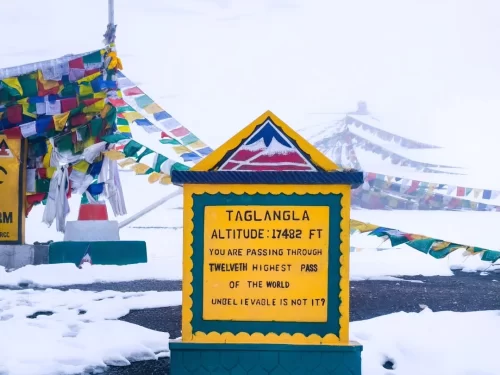
Tanglang La is a high-altitude mountain pass situated at an elevation of approximately 5,328 meters (17,480 feet) in the Ladakh region, often cited as the second-highest motorable pass on the Manali-Leh Highway.

Pologongka La high-altitude mountain pass BRO signboard fluttering prayer flags barren rugged mountains clear blue skies Ladakh India, scenic offbeat route Tso Moriri Tso Kar Leh-Manali highway adventure travel landmark. Mountain Pass

Pologongka La

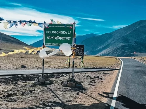
Pologongka La is a mountain pass situated at an elevation of approximately 4,940 meters (16,207 feet) in the Leh district of Ladakh.

Frequently Asked Questions About Puga Valley

Puga Valley is located in the Changthang region of eastern Ladakh between Nyoma and Tso Moriri and is known for its geothermal activity and vast open landscapes.
Puga Valley is approximately 180 to 200 kilometers from Leh and the drive usually takes 6 to 8 hours depending on road and weather conditions.
Travelers reach Puga Valley by driving from Leh toward Upshi and Nyoma and then continuing toward Tso Moriri through high altitude terrain.
Visitors require an Inner Line Permit to access Puga Valley because it lies within a restricted border region of eastern Ladakh.
The best time to visit Puga Valley is between June and September when roads are generally open and weather conditions are more stable.
Puga Valley is usually not accessible during peak winter months because heavy snowfall and extreme cold affect road connectivity in this region.
Puga Valley is unique for its natural hot sulfur springs bubbling mud pools and visible geothermal steam vents across the valley floor.
Travelers typically spend 30 to 60 minutes exploring Puga Valley as it is mainly a scenic and geological stop rather than a settlement with facilities.
Puga Valley lies at high altitude so visitors should be properly acclimatized before traveling. Senior citizens can visit if medically fit and comfortable with long mountain drives.
There are no permanent food stalls or accommodation facilities directly in Puga Valley though basic stays are available in nearby villages such as Nyoma and Karzok.
Road conditions toward Puga Valley include paved sections mixed with rough gravel stretches particularly closer to remote Changthang areas.
Puga Valley is often combined with Tso Moriri Lake Hanle or Nyoma as part of an extended eastern Ladakh circuit from Leh.

Loved this place ? Let’s Plan Your Ladakh Trip

Get customized Ladakh tour planning designed around altitude comfort, acclimatization time, weather windows, and real Himalayan road conditions. Whether you are visiting for high mountain passes, monasteries, lakes, or remote valley experiences, our exper

⚡ Quick Response | 💰 Free consultation | 🕒 24×7 expert support

×

Plan Your Trip