Quick Facts About Pangong Tso
| Entry Fee |
Free |
| Timings |
06:00 - 18:00 |
| Altitude (m) |
4250 |
| Ideal Visit Duration (hrs) |
48 |
| Best Time of Day |
Morning |
| Crowd Level |
High |
| Distance from Leh (km) |
160 |
| Walking Difficulty |
Moderate |
| Parking Available |
Yes |
| Last Mile Access |
Road |
| Suitable for Kids |
No |
| Suitable for Seniors |
No |
| Wheelchair Friendly |
No |
Why Visit Pangong Tso
Atmosphere The atmosphere at Pangong Tso is defined by its sheer scale and the hypnotic, shifting colors of its waters. Stretching nearly 134 km from India into Tibet, the lake is situated at an altitude of 4,225 meters, where the thin air renders the sunlight exceptionally sharp and the sky a deep, bruised indigo. There is a palpable sense of being at a geographical frontier. While the western end near Spangmik has become a hub of activity, the atmosphere remains one of rugged grandeur. The silence of the Changthang plateau is punctuated only by the sound of waves lapping against the shore—a sound more characteristic of an ocean than a landlocked lake—creating a sensory experience that is both vast and intimate.
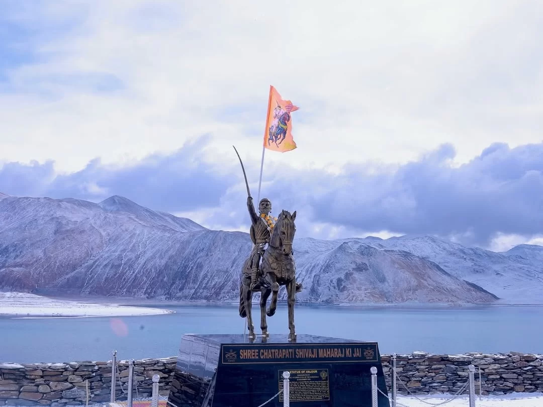
What Makes it Special Pangong Tso is a geological marvel, being one of the highest landlocked salt-water lakes in the world. What makes it truly special is its optical transformation; the water transitions through a spectrum of brilliant turquoise, cerulean, and deep navy as the sun moves across the sky. Unlike other lakes in Ladakh, Pangong is an endorheic basin, meaning it retains its water and allows no outflow, leading to a unique chemical composition that prevents it from hosting aquatic life, yet it freezes into a solid, glass-like sheet during winter. Beyond its cinematic fame, it is a critical corridor for migratory birds, including the Bar-headed goose and Brahminy ducks. Its location along the Line of Actual Control (LAC) adds a layer of strategic and historical gravity, making a visit here not just a scenic excursion, but a journey to one of the most significant borders in Central Asia.
Meta Title: Why Visit Pangong Tso | Atmosphere and Unique Features of the Blue Lake Meta Keywords: Pangong Tso, Pangong Lake Ladakh, Changthang Plateau, high altitude salt lake, Ladakh tourism, blue lake India, Spangmik Meta Description: Experience the ethereal atmosphere of Pangong Tso. Discover what makes this high-altitude salt lake special, from its shifting colors to its unique geological basin.
History and Cultural Significance of Pangong Tso
Pangong Tso, situated at an altitude of approximately 4,225 meters, is a 134-kilometer long endorheic lake that spans the border between India and China. Historically, the lake was a vital part of the trans-Himalayan geography, though its extreme salinity and frozen winters meant it was less of a permanent settlement hub and more of a landmark for nomadic movement. In the mid-19th century, during the expansion of the Dogra Empire under Gulab Singh, the lake became a defined frontier. The Treaty of Tingmosgang in 1684 and later boundary commissions have historically shaped the geopolitical status of this water body, which remains a sensitive international border today.
The cultural significance of Pangong Tso is deeply rooted in the traditions of the local Pangong-pa and Changpa people. For these communities, the lake is not just a body of water but a sacred entity. Local folklore often attributes the shifting colors of the lake to the moods of the deities residing in the surrounding mountains. Small shrines and mani walls (stone structures carved with Buddhist mantras) are found in the villages of Spangmik, Man, and Merak, signaling the spiritual protection sought by those living in this harsh, high-altitude environment.
- The Border Legacy: Unlike other lakes in Ladakh, Pangong Tso has a significant modern history tied to the 1962 conflict. This has shaped the lifestyle of the local residents, who have transitioned from purely nomadic pastoralism to a community that balances traditional livestock rearing with small-scale hospitality for travelers.
- Buddhist Pilgrimage: While there is no single large monastery on the lakes immediate shore, the local people are devout practitioners of Tibetan Buddhism. The lake is frequently visited by Rinpoches and monks from the Hemis and Chemrey monasteries to perform rituals that ensure the well-being of the land and its inhabitants.
- Nomadic Connectivity: Historically, the frozen lake served as a winter highway. Before the modern road network, caravans and locals would cross the thick ice to move between the remote valleys of Durbuk and the eastern plateaus, a practice that highlights the lakes role as a bridge rather than a barrier for indigenous populations.
- Ancestral Pastures: The villages of Man and Merak represent some of the oldest settled outposts in the region. The agricultural terraces here, though limited by the climate, represent centuries of effort to sustain life using the lakes proximity and mountain runoff.
Best Time to Visit Pangong Tso
Pangong Tso, situated at an altitude of 4,225 meters, is a landlocked river basin that undergoes a dramatic transformation each year. Unlike other tourist destinations, "best" is subjective here; it depends entirely on whether you want to witness the famous shifting blues of the water or walk across its solid, frozen surface. Due to its location behind the Chang La pass, accessibility is highly weather-dependent, and travelers must plan according to the seasonal opening of roads and camps.
- Summer Peak (June to August): This is the most popular time to visit. The lake is completely liquid, showcasing various shades of turquoise, blue, and green. Daytime temperatures are pleasant (15C to 20C), and all campsites in Spangmik, Lukung, and Maan are fully operational.
- Autumn (September to mid-October): The crowds thin out, and the water becomes even clearer. The air is crisp, and the surrounding mountains often get their first dusting of snow, providing excellent contrast for photography. However, night temperatures can drop to -5C, and many tented camps begin packing up by the second week of October.
- The Frozen Frontier (January to February): For extreme adventurers, this is the time to witness the "Pangong Frozen Lake Marathon" (usually held in late February). The lake freezes into a thick, glass-like sheet of ice capable of supporting vehicles. Expect temperatures as low as -25C and minimal facilities.
- The Thawing Period (April to May): The lake starts to transition from ice to water. It is a quiet time to visit, but the weather is highly unpredictable. The Chang La pass often experiences temporary closures during this period due to late spring snowfalls.
On-ground experience suggests that if you are visiting in the summer, the best time of day is early morning. By 2:00 PM, high-velocity winds typically sweep across the lake, making it uncomfortably cold and causing choppy waters that dull the lake's reflective quality. For 2026 travelers, the Korzok Gustor festival (July 17-18) at nearby Tso Moriri offers a great cultural pairing if you are timing your Pangong visit around mid-July.
How to Reach Pangong Tso
Pangong Tso is situated approximately 225 kilometers from Leh, spanning the border between India and China. Reaching the lake involves a high-altitude journey that typically takes 5 to 6 hours. The route is dominated by the crossing of the Chang La pass, one of the highest motorable roads in the world, requiring precise planning regarding altitude gain and weather windows.
The Standard Route: Leh via Chang La
- Route Map: Leh - Karu - Sakti - Zinral - Chang La - Durbuk - Tangste - Lukung - Spangmik.
- The Ascent: From Karu, the road climbs steeply toward Chang La (5,360 meters). This section is prone to ice and slush even in mid-summer. It is recommended to spend no more than 15-20 minutes at the top of the pass to avoid altitude-related distress.
- The Descent: Beyond Chang La, the road drops into the valley leading to Durbuk and Tangste. Tangste is the last major village where you can find basic medical facilities and guesthouses before reaching the lake.
The Shyok River Route (From Nubra Valley)
- Route Map: Diskit/Hunder - Agham - Shyok Village - Durbuk - Tangste - Pangong Tso.
- Strategic Link: This route allows travelers to move directly between Nubra Valley and Pangong Tso without returning to Leh. It saves a full day of travel and avoids re-crossing Khardung La.
- Road Conditions: The Shyok road is technically demanding. It runs parallel to the Shyok River and is highly susceptible to road washouts or closures during July and August due to rising water levels from glacial melt. Check local status in Diskit before attempting this path.
Permits and Essential Documentation
- Inner Line Permit (ILP): Pangong Tso is a sensitive border area. All visitors must obtain an ILP through the online portal or at the TIC office in Leh. You must carry physical copies for the checkpoints at Karu and Chang La.
- Restricted Zones: While tourists can visit Spangmik, Man, and Merak, certain areas further east toward Chushul require additional specific permits and are often restricted to domestic travelers only.
Transport and Practical Advice
- Vehicle Selection: A 4x4 or a high-ground-clearance SUV (like a Scorpio or Innova) is highly recommended. Small cars often struggle with the water crossings (nullahs) found on the descent from Chang La.
- Taxi and Shared Cabs: Private taxis are the standard for tourists. Shared taxis depart from the Leh bus stand early in the morning, usually around 6:00 AM.
- Public Bus: A JKSRTC bus operates from Leh to Spangmik on fixed days (typically Saturday and Sunday), returning the next day. This is the most economical but least flexible option.
- Fuel and Connectivity: There are no petrol pumps after Karu. Ensure your tank is full before leaving the Leh area. While BSNL and Airtel have limited connectivity in Tangste, there is virtually no data or reliable signal at the lakeshore in Spangmik.
Pangong Tso, situated at an altitude of approximately 4,225 meters (13,862 feet), is perhaps the most iconic landmark in Ladakh. Stretching 134 kilometers from India into China, this endorheic lake is famous for its saline water that remains crystal clear despite having no outlet. It is a high-altitude marvel that demands respect for its fragile ecosystem and the physical toll its elevation takes on the human body.
What to Expect at Pangong Tso
- Shifting Color Palette: One of the most striking features is the lake's ability to change colors. Depending on the time of day and cloud cover, the water shifts from turquoise and azure to deep indigo and even grey.
- The "3-Idiots" Effect and Crowds: Since the lake gained mainstream fame, the first point of contact (Lukung) can be crowded with tourists and movie-themed props. For a more authentic experience, expect to travel further along the shore toward Spangmik or Maan villages.
- Extreme Wind and Chill: The lake is situated in a funnel-like valley between the Pangong and Karakoram ranges. High-velocity winds are common, especially after 2:00 PM, which can make the perceived temperature feel significantly lower than the actual reading.
- Logistical Barriers: Reaching the lake requires crossing the Chang La pass (5,360 meters). Expect a long, 5 to 6-hour journey from Leh involving steep gradients, hairpin bends, and potential road blocks due to snow or stream crossings (pagal nallahs).
- Strict Environmental Codes: Being a sensitive border zone and an ecologically fragile area, plastic littering is heavily penalized. Expect limited access to the actual water's edge in certain areas to protect the shoreline.
- Limited Amenities: While luxury tents exist, most accommodation is in pre-fabricated huts or homestays. Expect limited running water, as pipes often freeze at night, and very restricted electricity (usually 7:00 PM to 11:00 PM).
- Military Presence: Due to its proximity to the Line of Actual Control (LAC), expect frequent army checkpoints and convoys. You must carry multiple physical copies of your Inner Line Permit (ILP) for verification at Tangste.
- Altitude Exhaustion: Even if you are acclimatized to Leh, the thin air at Pangong is noticeably different. Expect to feel lethargic; physical exertion like running or climbing small hills can lead to immediate breathlessness.
Important Visitor Information
Pangong Tso is the most iconic high-altitude lake in Ladakh, situated at 4,225 meters and spanning 134 kilometers into Tibet. While its fame has brought significant tourism, the environment remains extreme. This is a sensitive border zone under constant military surveillance, where the beauty of the shifting blue waters is balanced by the harsh reality of low oxygen and biting winds.
Pangong Tso
Crowd and Weather Notes
- Crowd Reality: Expect heavy foot traffic at "Shooting Point" near Spangmik, where most day-trippers congregate. To escape the crowds, travel further along the shore toward the villages of Man or Merak.
- Summer Weather: From June to August, days are bright with temperatures between 10C and 20C. However, the UV index is exceptionally high; you will burn quickly even in cold air.
- Monsoon Impact: While Ladakh is a rain shadow area, the routes to Pangong (especially the Shyok road and Chang La) often face "pagal nallas" (flash floods from glacial melt) in July and August, which can strand vehicles for hours.
- The Winter Freeze: By January, the saltwater lake freezes into a thick sheet of ice capable of supporting vehicles. Temperatures drop to -25C, and only a few hardy homestays in the villages remain open with dry toilets and no running water.
Peak and Quiet Hours
- Peak Hours: 11:00 AM to 3:00 PM is when the lake is loudest. This is the peak time for day-trippers from Leh who arrive, take photos, and leave.
- Quiet Hours: 6:00 AM to 8:00 AM. Before the tourist taxis arrive, the lake is like a mirror. This is also the best time for birdwatching before human activity scares off the migratory species.
- Golden Hour: Photography is best around 4:30 PM to 6:00 PM when the sun hits the mountains on the northern bank, turning them deep orange and purple against the sapphire water.
Dress Code and Packing
- Windproof Gear: The wind at Pangong is more challenging than the temperature. A high-quality windbreaker or hardshell jacket is more important than a heavy wool sweater.
- Layering: Wear a base layer of thermals even in summer. The temperature can drop by 10 degrees in minutes if clouds block the sun.
- Footwear: Wear boots with good grip. The shoreline is composed of loose pebbles and slippery salt-crusted rocks that can lead to ankle injuries.
- Eye Protection: Polarized sunglasses are essential to block the intense glare reflecting off the blue water and salt deposits.
Safety Notes
- The Chang La Factor: Reaching Pangong requires crossing Chang La (5,360m). Do not spend more than 15-20 minutes at the pass to avoid high-altitude pulmonary edema (HAPE).
- Zero Connectivity: Do not rely on GPS or mobile data. Only BSNL/Airtel postpaid may work intermittently near Tangste; there is effectively no signal at the lakeside camps.
- Water Caution: The water is glacial and hypersaline. Swimming is strictly prohibited as it can lead to immediate hypothermia and disturbs the nesting sites of endangered birds like the Black-necked Crane.
- Fuel and Cash: The last reliable petrol pump is in Karu (over 100km away). Carry extra fuel if you plan to explore Merak or Chushul. There are no ATMs; carry enough cash for your entire stay and return journey.
- Border Sensitivity: This is an active border area. Do not fly drones without explicit military permission, and stay on marked paths to avoid straying into restricted zones.
Photography and Viewpoints at Pangong Tso
Pangong Tso is a 134-kilometer-long endorheic lake that spans the border between India and China. Renowned for its shifting color palette—ranging from turquoise and cerulean to deep indigo—the lake is a high-altitude desert marvel at 4,225 meters. For photographers, the challenge lies in capturing the true scale of the landscape and the intense clarity of the light. The lake is most vibrant during the middle of the day when the sun is high, while the "blue hour" provides a serene, moody atmosphere that highlights the textures of the surrounding barren mountains.
- Lukung and Spangmik Vantage: These are the most accessible points, offering the classic "Three Idiots" view. To avoid the crowds of yellow scooters and props, head further east toward Spangmik. The shoreline here features unique rock formations and small inlets that provide excellent foreground interest for wide-angle shots.
- Maan and Merak Shores: These villages sit further along the lake and offer a much quieter environment. The water here is often calmer, making it the best location for capturing the mirror-like reflections of the snow-capped peaks of the Karakoram Range. The lack of commercial activity here ensures a cleaner, more natural frame.
- The Rezang La Pass Approach: As you descend toward the lake from the higher passes, there are several "u-turn" viewpoints. These spots allow you to capture the "snake-like" curvature of the lake as it disappears into the horizon toward Tibet, providing a sense of scale that is impossible to get from the water's edge.
- The 3 Idiots Point (Early Morning): While commercialized, this point has specific sandbars that jut into the lake. If visited at dawn, before the day-trippers arrive from Leh, you can use these leading lines to draw the viewer's eye toward the center of the lake.
- Chushul Marshes: Located at the far end of the accessible Indian side, the marshes near the lake are home to Brahmini ducks and Bar-headed geese. This is a prime spot for wildlife photographers looking to capture high-altitude avian life against the backdrop of the saline blue water.
Near By Attraction
 Mountain Pass
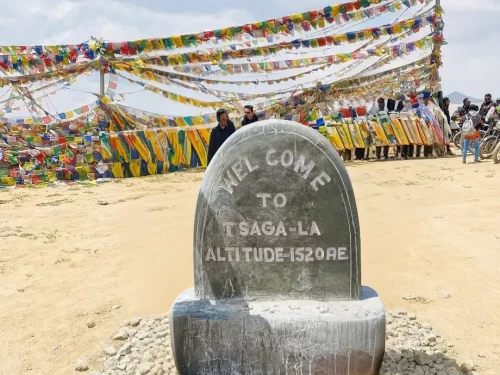
Tsaga la Pass
Tsaga La is a high-altitude mountain pass situated at an elevation of approximately 4,611 meters (15,128 feet) in the Leh district, connecting the villages of Tsaga and Loma.
 Mountain Pass
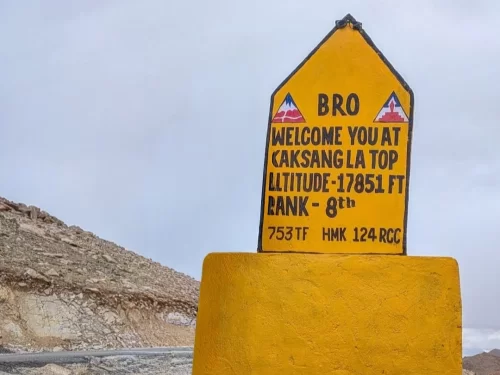
Kaksang La Pass
Kaksang La is a high-altitude mountain pass situated at an elevation of approximately 5,438 meters (17,841 feet) in the Leh district of Ladakh.
 Mountain Pass
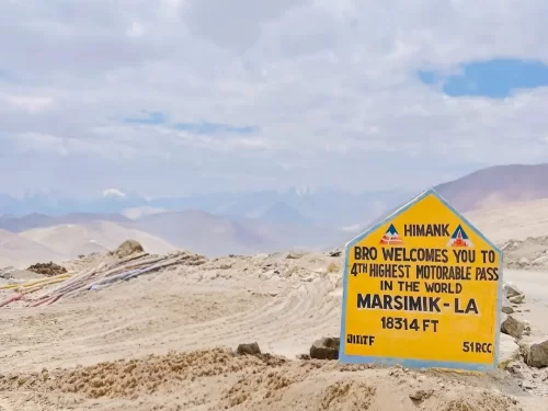
Marsimik La Pass
Marsimik La is a high-altitude mountain pass situated at an elevation of approximately 5,582 meters (18,314 feet) in the eastern Ladakh region, near the northern shore of Pangong Tso.