Namika La Pass: High-Altitude Mountain Pass on Srinagar-Leh Highway, Ladakh, India

Namika La Pass , Kargil
Tourists traverse Namika La as one of the two major high-altitude passes on the Srinagar-Leh National Highway (NH1), located between Kargil and Leh. The pass is a frequent stop for road-trippers and motorcyclists to photograph the expansive views of the barren, ochre-colored mountain ridges and to visit the nearby 7th-century rock-cut Maitreya Buddha statue in Mulbekh.

Quick Facts About Namika La Pass

Entry Fee Free
Timings 06:00 - 18:00
Altitude (m) 3700
Ideal Visit Duration (hrs) 0.25
Best Time of Day Morning
Crowd Level Moderate
Distance from Leh (km) 160
Walking Difficulty Easy
Parking Available Yes
Last Mile Access Road
Suitable for Kids Yes
Suitable for Seniors Yes
Wheelchair Friendly No

Why Visit Namik La Pass on the Srinagar-Leh Highway

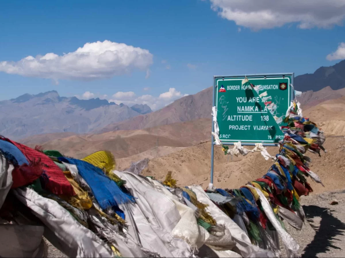
Namik La, known as the "Pillar of the Sky," stands at an elevation of 12,139 feet and serves as one of the two major high-altitude passes between Kargil and Leh. Travelers visit this site to experience the dramatic transition from the lush, green valleys of Kashmir to the stark, rain-shadow landscapes of the Trans-Himalayas, marking a significant entry point into the cultural heart of Buddhist Ladakh.

The on-ground atmosphere is defined by its ancient, weathered rock formations and the immense sense of verticality provided by the surrounding barren peaks. Unlike the snow-heavy passes of the Greater Himalayas, Namik La offers a dry, high-desert environment where the silence is punctuated by the snapping of colorful prayer flags and the panoramic views of the winding NH1 highway carved into the rugged brown mountainside.

What makes Namik La distinct is its unique geological character, featuring jagged limestone pillars and deep-cut gorges that give the pass its descriptive name. It provides an essential vantage point for travelers to appreciate the sheer scale of the Zanskar Range and serves as a historical gateway to the nearby Maitreya Buddha statues and the ancient monastic complex of Mulbekh, blending natural grandeur with deep spiritual significance.

Historical and Geographic Significance of Namik La Pass

Namik La, known as the "Pass of the Sky Escarpment," is a high-altitude mountain pass situated at an elevation of 3,700 meters (12,139 feet) on the Srinagar-Leh Highway. It is one of the two major passes between Kargil and Leh, marking a significant transition point within the Zanskar Range.

Geographically, the pass serves as a gateway to the Buddhist-dominated regions of Ladakh from the west. The landscape is characterized by stark, wind-eroded rock formations and deep vertical cliffs, which inspired its name. It acts as a natural barrier that separates the Pashkyum valley from the central Ladakhi plateau.

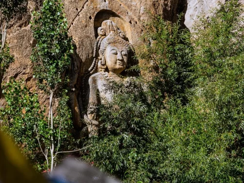
Historically, Namik La has been a vital link on the ancient silk routes that connected the Kashmir Valley to Tibet and Central Asia. The surrounding area is home to ancient rock carvings and Buddhist monuments, most notably the 7th-century Maitreya Buddha at Mulbekh located at the base of the pass. Today, it remains a critical logistical artery maintained by the Border Roads Organization (BRO), ensuring year-round connectivity for both military and civilian transit until the onset of peak winter snowfall.

Best Time to Visit Namik La Pass

Namik La, often called the "Pillar of the Sky," is one of the two high-altitude mountain passes on the Srinagar-Leh Highway (NH1) situated at 12,139 feet. Unlike the more remote passes of Eastern Ladakh, its accessibility is tied to the opening of the Zoji La gateway, making it a primary transit point for travelers moving between Kargil and Leh during the warmer months.

  • Ideal months: June to September is the peak window for travel, with September offering the crispest skies and most stable tarmac conditions for navigating the Zanskar Range.
  • Weather conditions: During the summer, daytime temperatures typically range from 10°C to 20°C; however, the pass is notorious for its sudden, sharp winds and high-altitude exposure, which can cause the effective temperature to feel much lower than the actual reading.
  • Periods to avoid: Avoid travel from November to April when the Srinagar-Leh Highway is officially closed due to heavy snow accumulation at Zoji La, rendering Namik La inaccessible by road; additionally, late July and August can be unpredictable due to monsoon-triggered landslides on the Kargil-side approaches, even though the pass itself sits in a rain-shadow zone.

How to Reach Namik La Pass

Namik La, known as the "Pillar of the Sky," is one of two high-altitude passes on the Srinagar-Leh Highway (NH1). Situated at an elevation of approximately 3,700m (12,139 ft) in the Zanskar Range, it serves as a critical link between the Buddhist-dominated Mulbekh and the Muslim-dominated Kargil region.

  • Nearest Airport: Kushok Bakula Rimpochee Airport (IXL) in Leh is approximately 165 km to the east. Alternatively, Srinagar International Airport (SXR) is located about 265 km to the west. Most travelers cross this pass while transiting between Srinagar and Leh.
  • Nearest Railway Station: Jammu Tawi is the closest major railhead, located roughly 520 km away. From Jammu, travelers typically hire private taxis or take state-run buses via Srinagar and Kargil.
  • Road Access via NH1: The pass is located directly on the National Highway 1. If traveling from Srinagar, the route goes through Sonamarg, Zoji La, and Kargil. If coming from Leh, the route passes through Nimmu, Khalsi, and Lamayuru.
  • Last-Mile Connectivity: Unlike the more remote passes in Changthang, Namik La is accessible via standard vehicles, including sedans and hatchbacks, as the highway is well-paved and maintained by the Border Roads Organization (BRO). Regular JKSRT buses and shared taxis plying the Srinagar-Leh route pass through here daily.
  • Travel Conditions: The pass is generally open from April/May to November. While it is lower than the passes on the Manali-Leh road, winter snow can cause temporary closures. The ascent is characterized by gradual gradients and well-engineered switchbacks, making it less physically demanding than Zoji La.
  • Practical Considerations: Although Namik La is lower in altitude, travelers should still be mindful of AMS if they have just arrived in the region. The nearest medical facilities and fuel stations are located in Kargil (50 km west) or Mulbekh (approx. 15 km east). There is a prominent Maitreya Buddha statue in Mulbekh that serves as a common stopping point for travelers before or after the ascent.

What to Expect When You Visit Namik La

  • Environment and Surroundings: Located at an altitude of 3,720 meters (12,205 feet) on the Srinagar-Leh Highway, Namik La is the "Pillar of the Sky" pass. The landscape is characterized by unique, vertical rock formations and sharp, jagged ridges that differ from the rounded hills of central Ladakh. The environment is arid and stark, offering clear views of the Zanskar Range and the winding road below.
  • Facilities and Amenities: There is no commercial infrastructure at the summit. You will find no restaurants, shops, or restrooms. Aside from a few signboards and Buddhist prayer flags, the pass is undeveloped. The nearest basic facilities, including small eateries and public conveniences, are located in the villages of Mulbekh or Budhkharbu, several kilometers away in either direction.
  • Accessibility and Movement: The pass is situated on NH1 and is generally well-paved, though it remains prone to landslides during the monsoon and heavy snow in winter. The ascent from the Kargil side is steady but involves several sharp hairpin bends. It is typically accessible from April to November, with movement occasionally restricted by slow-moving military convoys or road maintenance crews.
  • Typical Visitor Behavior and Conditions: Most travelers stop briefly for 10–15 minutes to photograph the dramatic rock scenery and the summit marker. While lower in altitude than the passes in the Khardung or Changthang regions, the thin air can still cause mild shortness of breath. Visitors generally use this as a quick acclimatization point while transitioning between the lush valleys of Kashmir and the high-altitude desert of Leh.

Essential Visitor Information for Namik La Pass

  • Crowd and Weather: Standing at 3,700 meters (12,139 feet) on the Srinagar-Leh Highway, Namik La experiences moderate transit traffic; the weather is typically dry and arid, with high-intensity solar radiation during the day and sharp, cold winds that funnel through the surrounding barren peaks.
  • Peak and Quiet Visiting Hours: Highest activity occurs between 10:00 AM and 3:00 PM as travelers move between Kargil and Leh; early morning (7:00 AM – 9:00 AM) offers the most tranquil experience and softer lighting for photographing the unique rock formations of the Zanskar range.
  • Dress Code: Light-to-medium layering is usually sufficient during the day; a windproof jacket over a light fleece is recommended, along with a wide-brimmed hat and high-SPF sunscreen to protect against the exceptionally high UV levels found in this dry sector.
  • Safety and Practical Cautions: While lower than the passes of the Changthang, the ascent from Mulbekh involves several sharp switchbacks; ensure your vehicle's brakes are checked for the long descent towards Bodh Kharbu, and stay hydrated to combat the extremely dry air which can cause rapid dehydration.
  • Experience-Based Notes: The pass is marked by a distinctive sign and numerous prayer flags; unlike the snowy passes of the Zanskar range, Namik La (the "Pass of Sky") is often snow-free in summer, offering a stark, "moonland" aesthetic similar to nearby Lamayuru.

Capturing the High-Altitude Formations of Namik La Pass

Namik La, the "Pass of the Sky Pillars," sits at an altitude of 3,700 meters (12,139 feet) on the Srinagar-Leh Highway. It is renowned for its distinctive geological features, characterized by vertical limestone "pillars" and jagged sedimentary ridges that contrast sharply with the softer contours of the surrounding Zanskar Range.

  • The "Sky Pillars" Perspective: The most iconic photographic subject is the unique rock formations resembling natural pillars. These are best captured 1 kilometer before the summit from the Kargil side, using a mid-range telephoto lens (50-85mm) to emphasize their verticality against the sky.
  • The Descent Toward Jaktang: Facing east from the summit marker, the road unfolds in a series of dramatic, sweeping curves toward the valley floor. This offers a classic "Himalayan highway" shot, particularly effective when framed with the colorful prayer flags in the foreground for a sense of place.
  • Lighting and Color Depth: Late afternoon (4:00 PM – 5:30 PM) is the superior time for photography. The setting sun hits the limestone faces at an angle, turning the grey and beige rocks into warm gold and orange tones, while the deep shadows provide the necessary definition to the jagged ridges.
  • Atmospheric Clarity: While lower than the passes of the Changthang, Namik La is prone to heat haze during midday in peak summer. Shooting during the "blue hour" just after sunset can produce ethereal images of the road as it fades into the silhouettes of the mountains.
  • Traffic and Safety: As a primary artery for the Indian Army and commercial trucks, the pass is constantly busy. Use the wide shoulders near the summit stupas to set up your tripod. Avoid standing on the outer edge of the hairpin bends, as long-wheelbase trucks require the full width of the road to maneuver.

Near By Attraction

Close-up of majestic 9-meter 8th-century rock-carved Maitreya Buddha statue with ornate crown serene face carved into Mulbekh cliff overgrown with lush green poplars bushes against rugged brown Ladakh rock, perfect India Leh Kargil Buddhist heritage tour  Monastery

Mulbekh Monastery

Mulbekh Monastery is a dual Tibetan Buddhist monastery consisting of two gompas (Serdung and Rgaldan-se) overlooking the Srinagar-Leh Highway at an elevation of approximately 3,304 meters (10,840 feet).

A vibrant yellow BRO sign marks the summit of Fotu La Pass at 13,479 feet, set against the sweeping, arid slopes and rugged peaks of the Himalayan landscape on the Srinagar-Leh highway. Mountain Pass

Fotu La Pass

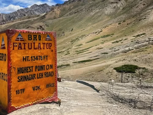
Fotu La is a high-altitude mountain pass situated at an elevation of approximately 4,108 meters (13,478 feet) in the Zanskar Range of the Himalayas.

Sapi La pass BRO signboard 4370m altitude snowy rugged mountains cloudy skies Ladakh India, high-altitude BRO achievement Nyoma-Leh route Changthang scenic drive Tso Moriri detour. Mountain

Sapi La

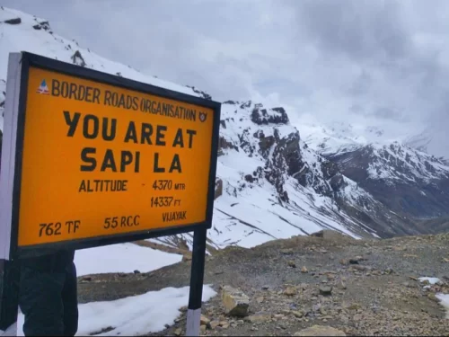
Sapi La is a high-altitude mountain pass in Ladakh that connects Shargole and Sapi Valley on a motorable road

Frequently Asked Questions About Namika La Pass

Namika La Pass is located on the Srinagar Leh Highway in western Ladakh between Kargil and Lamayuru. It lies northwest of Leh city at an altitude of over 12000 feet and forms part of the main road route connecting Ladakh with Kashmir.
Namika La Pass can be reached from Leh city by driving toward Kargil on National Highway 1. The journey takes around four to five hours depending on traffic and road conditions.
No separate permit is required specifically for Namika La Pass when traveling on the Srinagar Leh Highway. Travelers should carry valid identification while journeying from Leh city.
The best time to visit Namika La Pass in Ladakh is from May to October when the highway remains open and weather conditions are relatively stable. Winter access depends on snow clearance along the route.
Namika La Pass stands at an altitude of about 12100 feet where oxygen levels are lower than in Leh city but generally manageable for most travelers. Short stops usually do not cause significant discomfort.
There are no permanent food stalls or accommodation facilities directly at Namika La Pass. Travelers can find meals and stays in Kargil, Lamayuru, or Leh city before or after crossing the pass.
A regular car in good condition can reach Namika La Pass during the open season as it lies on a national highway. Drivers should still remain cautious due to mountain curves and occasional rough stretches.
Travelers usually spend 10 to 15 minutes at Namika La Pass for photographs and a short break. Extended stays are not common as it is mainly a transit point along the highway.
Visitors should wear light warm layers and carry a windproof jacket when visiting Namika La Pass. Weather can change quickly even during summer months.
Namika La Pass can sometimes be accessed in winter depending on snowfall and road clearance, but travel plans should be confirmed through official updates from Leh city or Kargil authorities.
Namika La Pass is generally suitable for families including senior citizens and children as it is lower in altitude compared to many other Ladakh passes. Gradual travel from Leh city helps maintain comfort.
Mobile network coverage at Namika La Pass is limited and may be intermittent. Signals are more reliably available in nearby towns such as Kargil or Leh city rather than at the summit itself.

Loved this place ? Let’s Plan Your Ladakh Trip

Get customized Ladakh tour planning designed around altitude comfort, acclimatization time, weather windows, and real Himalayan road conditions. Whether you are visiting for high mountain passes, monasteries, lakes, or remote valley experiences, our exper

⚡ Quick Response | 💰 Free consultation | 🕒 24×7 expert support

×

Plan Your Trip