Nakee La Pass: High-Altitude Mountain Pass on Manali-Leh Highway, Ladakh, India

Nakee La Pass , Leh
Tourists traverse Nakee La as it is the third of five major passes on the route from Manali to Leh, located immediately above the 21 hairpin bends of the Gata Loops. The pass is a significant milestone for adventure travelers and bikers, offering a stark, lunar-like landscape characterized by barren peaks and high-velocity winds.

Quick Facts About Nakee La Pass

Entry Fee Free
Timings 06:00 - 18:00
Altitude (m) 4739
Ideal Visit Duration (hrs) 0.25
Best Time of Day Morning
Crowd Level Moderate
Distance from Sarchu (km) 85
Walking Difficulty Easy
Parking Available Yes
Last Mile Access Road
Suitable for Kids Yes
Suitable for Seniors Yes
Wheelchair Friendly No

Why Visit Nakee La Pass on the Manali-Leh Highway

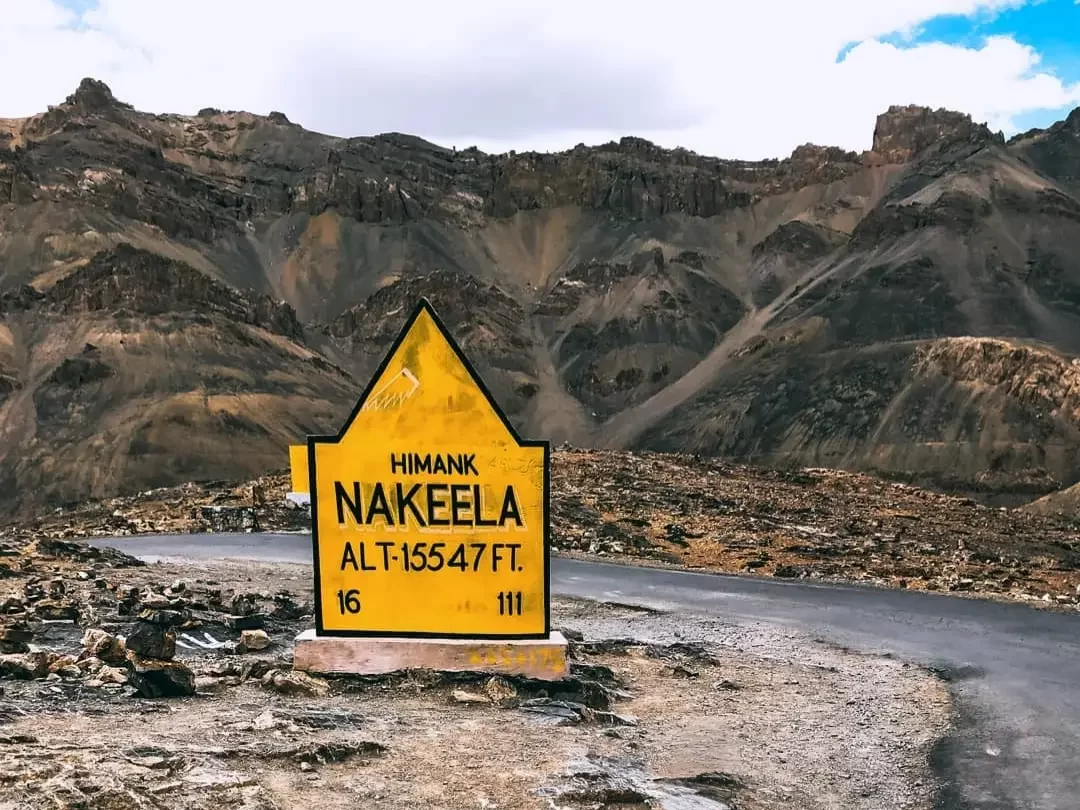
Travelers ascend Nakee La Pass primarily as a critical milestone on the legendary Manali-Leh Highway, situated at an elevation of 15,547 feet. It is most famous for being the site of the 21 Gata Loops, a series of hairpin bends that challenge drivers and cyclists while providing a necessary transition between the lower valleys of Lahaul and the high-altitude plateaus of Ladakh.

The atmosphere at Nakee La is dominated by the sheer scale of the surrounding limestone mountains and the rhythmic, dizzying perspective of the loops below. The air is notably crisp and thin, creating a sense of stark isolation where the only sounds are the whistling wind and the occasional hum of heavy BRO convoys traversing the dusty, sun-bleached terrain.

This pass is distinct for its dramatic topographical shift and the local lore surrounding the "Ghost of Gata Loops," where travelers often leave water bottles at a roadside shrine. It offers a unique vantage point to witness the geological transition of the Zanskar Range, making it a pivotal site for those documenting the raw, engineering-defying transit of the Indian Himalayas.

Historical and Geographic Significance of Nakee La Pass

Nakee La Pass is a high-altitude mountain pass situated at an elevation of 4,739 meters (15,547 feet) along the Leh-Manali Highway in the Ladakh region. It represents the third of five major passes encountered when traveling from Manali to Leh, positioned between Sarchu and Pang.

The pass is defined by the 21 Gata Loops, a series of twenty-one hairpin bends that ascend the mountainside, showcasing the engineering required to navigate the Trans-Himalayan terrain. This stretch is a vital logistical link for the Border Roads Organization (BRO), ensuring the movement of supplies and travelers through the rugged Lahaul and Ladakh mountain ranges.

Local significance is marked by the presence of a roadside shrine dedicated to a ghost story involving a stranded truck driver, which has become a modern cultural fixture where travelers leave water bottles as a gesture of safe passage. Geographically, Nakee La serves as a critical transition point into the high-altitude arid desert, characterized by its lack of vegetation and oxygen-thin atmosphere.

Best Time to Visit Nakee La Pass

Nakee La, situated at 15,547 feet on the Manali-Leh Highway, is a transit-critical mountain pass that is only navigable when the Border Roads Organization clears the winter snowpack. Its accessibility is strictly dictated by the seasonal opening of the highway, typically offering a narrow window for travelers to traverse its famous 21 Gata Loops.

  • Ideal months: June to September represent the only viable window, with June being the most dramatic for snow walls and September offering the most stable road conditions and crisp, clear vistas.
  • Weather conditions: Expect extreme temperature fluctuations where intense high-altitude radiation provides warmth in direct sunlight, while blistering cold winds across the pass can drop the effective temperature to near freezing even at midday.
  • Periods to avoid: October to May must be avoided as the pass is buried under heavy snow and officially closed to civilian traffic; additionally, the peak monsoon weeks of late July and August are hazardous due to frequent landslides and water crossings (nullahs) becoming turbulent on the ascent from Sarchu.

How to Reach Nakee La Pass

Nakee La Pass, situated at an elevation of approximately 4,740m (15,551 ft), is a vital high-altitude transit point on the Leh-Manali Highway. It is famous for being the third of the five passes encountered while traveling from Manali to Leh and is located between Sarchu and Pang.

  • Nearest Airport: Kushok Bakula Rimpochee Airport (IXL) in Leh is the closest domestic airport, approximately 190 km away. Alternatively, Kullu-Manali Airport (KUU) in Bhuntar is roughly 285 km from the pass.
  • Nearest Railway Station: Joginder Nagar Railway Station (narrow gauge) is about 410 km away, while Chandigarh Railway Station (broad gauge) is approximately 580 km away, making road travel the only practical entry method.
  • Road Access and Gata Loops: The pass is accessible via the NH3 (Leh-Manali Highway). Travelers approaching from the Manali side must negotiate the "Gata Loops"—a series of 21 hair-raising hairpin bends that climb steeply from the Sarchu plains to the approach of Nakee La.
  • Last-Mile Connectivity: There is no public transport directly to the pass. Travel is conducted via private taxis, self-drive SUVs, or expedition-grade motorcycles. The road is maintained by the Border Roads Organization (BRO), but the surface often features loose gravel and potholes due to heavy winter snow melt.
  • Travel Limitations: The pass is seasonally restricted and typically remains open only from June to October. Even in summer, the pass can experience sudden snowfall. Due to the rapid altitude gain via the Gata Loops, travelers are at high risk of Acute Mountain Sickness (AMS); it is advised to transit quickly and avoid long halts at the summit.
  • Infrastructure Constraints: There are no fuel stations, mechanical workshops, or medical facilities within a 70 km radius of Nakee La. Travelers must ensure they have sufficient fuel from Tandi or Karu and carry emergency oxygen and basic repair kits.

What to Expect When You Visit Nakee La Pass

  • Environment and Surroundings: Located at an altitude of 4,739 meters (15,547 feet) on the Manali-Leh Highway, the pass is defined by a stark, high-altitude alpine desert environment. It is the third of five high passes on the route and is characterized by the 21 Gata Loops, a series of hairpin bends leading up to the summit where strong crosswinds and dusty conditions are frequent.
  • Facilities and Amenities: There are no permanent structures, electricity, or running water at the pass. While occasional temporary seasonal stalls (Dhabas) may be found at the base of the Gata Loops or in nearby Sarchu, the summit itself lacks any medical, mechanical, or sanitary facilities.
  • Accessibility and Movement: The road is paved but subject to heavy degradation from winter snow and heavy truck traffic. Movement is often slow due to the steep gradient of the Gata Loops and the presence of heavy freight convoys; the pass is typically only accessible between June and October, depending on snow clearance.
  • Typical Visitor Behavior and Conditions: Most travelers experience the pass as a transit point rather than a long-stay destination. Rapid ascent via the loops often triggers symptoms of altitude sickness, so visitors generally stop briefly for photography and acclimatization before descending toward Sarchu or Whiskey Nala to minimize time spent at peak elevation.

Essential Visitor Information for Nakee La Pass

  • Crowd and Weather: Located at 4,739 meters (15,547 feet), Nakee La is a high-transit but less-celebrated pass on the Manali-Leh Highway; expect raw, lunar-like landscapes with intense, biting winds and highly unpredictable weather that can shift from bright sunshine to moderate snowfall within minutes.
  • Peak and Quiet Visiting Hours: Most travelers cross between 9:00 AM and 3:00 PM as part of the Day 2 transit between Sarchu and Leh; early morning crossings (before 8:00 AM) are the quietest but coldest, while late afternoon transits are discouraged due to dropping temperatures and lack of nearby facilities.
  • Dress Code: Wind-blocking layers are essential; wear a heavy windcheater or down jacket over thermals, and ensure you have a woolen cap (balaclava), polarized sunglasses to prevent snow/sun blindness, and insulated gloves.
  • Safety and Practical Cautions: Limit your stay at the summit to 5–10 minutes to avoid Acute Mountain Sickness (AMS); the pass is situated immediately above the 21 hairpin bends of the Gata Loops, where the rapid altitude gain (from 4,250m to 4,739m) frequently triggers nausea and headaches.
  • Logistics and Infrastructure: There are no shops, settlements, or mobile connectivity at the pass; the nearest emergency transit camps and basic food stalls are located at Sarchu (40 km south) or Pang (40 km north).

Best Viewpoints and Photography Guide for Nakee La Pass

Situated at an altitude of 4,739 meters (15,547 feet) on the Leh-Manali Highway, Nakee La is defined by its dramatic limestone terrain and the legendary 21 Gata Loops that precede it. Capturing the essence of this pass requires planning for its unique geography and high-contrast environment.

  • The Gata Loops Perspective: The most iconic shot is not at the summit itself but from the ascent. Stop at the pull-offs between loops 18 and 21 to capture the serpentine road below, which provides a powerful visual narrative of the climb's scale.
  • Summit Panoramas: From the Nakee La marker, face westward to photograph the stark, jagged peaks of the Zanskar Range. The landscape here is almost entirely devoid of vegetation, offering a "moonscape" aesthetic that benefits from wide-angle lenses.
  • Lighting Strategy: Early morning (7:00 AM – 9:00 AM) is the most favorable time for photography. The sun rises behind the pass, illuminating the valley walls and deep canyons with a soft glow while avoiding the harsh, vertical shadows that flatten the landscape by noon.
  • Environmental Constraints: High-altitude dust and wind are constant factors. It is vital to avoid lens changes in the open air to prevent sensor contamination. Use a fast shutter speed to compensate for wind-induced camera vibration if using a tripod.
  • Access and Drone Regulations: While standard photography is unrestricted, the pass is a critical transit point for Indian Army convoys. Drone usage is strictly prohibited without prior military and civil authorization due to the proximity to sensitive border regions.

Near By Attraction

Magnetic Hill sign at Ladakh BRO during clear skies, featuring altitude 11312 ft board yellow mountains highway, perfect adventure Ladakh tour package.  Tourist Attraction

Magnetic Hill

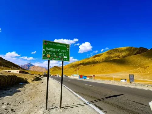
Magnetic Hill is a gravity hill located at an elevation of approximately 3,350 meters (10,991 feet) on the Leh-Srinagar National Highway.

Buddha statue at Alchi Gompa Ladakh in dimly lit shrine during misty weather, featuring multiple arms prayer scarves and wall murals, perfect spiritual Ladakh tour package. Monastery

Alchi Monastery

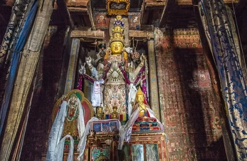
Alchi Monastery is a historic Buddhist temple complex situated at an elevation of approximately 3,100 meters (10,170 feet) on the southern bank of the Indus River.

Memorial at Changla Pass 17688 ft during overcast skies, featuring prayer flags, Indian tricolor, snowy mountains, perfect spiritual adventure Ladakh tour pack Mountain Pass

Chang La Pass

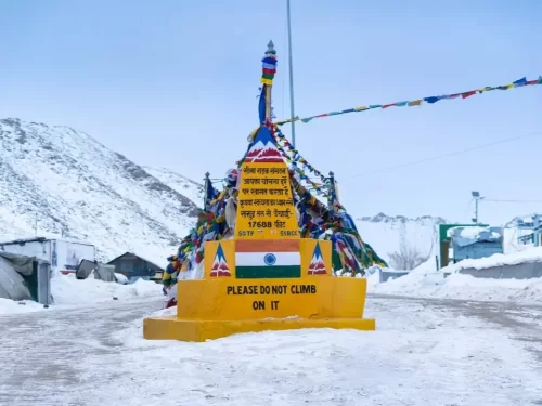
Chang La is a high-altitude mountain pass situated at an elevation of approximately 5,360 meters (17,585 feet) on the road between Leh and Pangong Tso.

Frequently Asked Questions About Nakee La Pass

Nakee La Pass is located on the Leh Manali Highway in Ladakh between Sarchu and Pang. It stands at an elevation of around 4700 meters and forms part of the high altitude mountain route connecting Leh city with Himachal Pradesh.
Nakee La Pass can be reached by road from Leh city in Ladakh while traveling toward Manali. The drive usually takes several hours depending on weather and road conditions along the Leh Manali Highway.
No separate permit is required specifically for Nakee La Pass in Ladakh when traveling on the Leh Manali Highway. Travelers should still carry valid identification while journeying from Leh city.
The best time to visit Nakee La Pass in Ladakh is from June to September when the highway remains open for regular traffic. Access outside this period depends on snow clearance and weather stability.
Most visitors spend 10 to 20 minutes at Nakee La Pass in Ladakh for short breaks and photographs. It is generally a transit stop rather than a standalone sightseeing destination.
Nakee La Pass in Ladakh can be visited by families who are accustomed to long mountain drives. Proper acclimatization in Leh city is important before crossing high altitude passes.
Road conditions at Nakee La Pass in Ladakh include steep ascents, sharp curves, and occasional rough patches. Careful driving is necessary due to altitude and changing mountain weather.
There are no food stalls or fuel stations directly at Nakee La Pass in Ladakh. Travelers should refuel and arrange meals at Leh city, Sarchu, or other designated highway stops.
Nakee La Pass is situated at high altitude in Ladakh where oxygen levels are lower than in plains. Some travelers may feel mild breathlessness if they ascend rapidly without spending time in Leh city first.
Nakee La Pass in Ladakh is commonly combined with travel toward Sarchu, Pang, or Manali as part of the Leh Manali Highway journey. It naturally fits into longer road circuits starting from Leh city.
Mobile network coverage at Nakee La Pass in Ladakh is generally unavailable due to its remote location. Travelers should inform family members before leaving Leh city and not rely on connectivity along this stretch.

Loved this place ? Let’s Plan Your Ladakh Trip

Get customized Ladakh tour planning designed around altitude comfort, acclimatization time, weather windows, and real Himalayan road conditions. Whether you are visiting for high mountain passes, monasteries, lakes, or remote valley experiences, our exper

⚡ Quick Response | 💰 Free consultation | 🕒 24×7 expert support

×

Plan Your Trip