Chang La Pass: High-Altitude Mountain Pass in Leh District, Ladakh, India

Chang La Pass , Leh
Tourists visit Chang La because it is the primary gateway to the Changthang Plateau and serves as a critical transit point for reaching Pangong Lake. The pass is known for its steep ascent, permanent snow cover at the summit, and as the location of the world\'s highest research station established by the Defence Research and Development Organisation.

Quick Facts About Chang La Pass

Entry Fee Free
Timings 00:00 - 23:59
Altitude (m) 5360
Ideal Visit Duration (hrs) 0.25
Best Time of Day Morning
Crowd Level High
Distance from Leh (km) 75
Walking Difficulty Moderate
Parking Available Yes
Last Mile Access Road
Suitable for Kids No
Suitable for Seniors No
Wheelchair Friendly No

Why Visit Chang La Pass in Ladakh

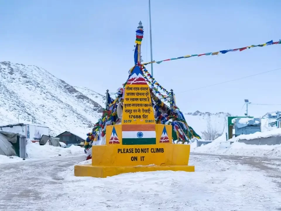
Chang La Pass serves as the formidable high-altitude gateway to the Pangong Tso region, standing at an elevation of 17,586 feet in the Ladakh Range. Travelers ascend this pass to experience one of the highest motorable roads in the world, making it a vital and thrilling transit point for anyone journeying from the Indus Valley toward the remote eastern borderlands of the Changthang plateau.

The atmosphere at the summit is defined by its extreme conditions, where heavy snow persists for much of the year and the air is noticeably thin and crisp. Visitors encounter a landscape of raw, crystalline beauty, characterized by fluttering prayer flags and a small mountain shrine, all surrounded by jagged, snow-dusted peaks that offer a visceral sense of the sheer scale of the Trans-Himalayas.

What makes Chang La distinct is its proximity to the world’s highest research station established by the DRDO and its role as a challenging test of endurance for drivers and cyclists. It offers a unique topographical transition where the steep, rocky ascent from Karu opens up into the vast, high-altitude nomadic grazing lands, providing travelers with unparalleled panoramic views of the distant Karakoram range and the hidden valleys below.

Historical and Geographic Significance of Chang La Pass

Chang La Pass is a high-altitude mountain pass situated at an elevation of 5,360 meters (17,585 feet) in the Ladakh Range. It serves as the primary gateway between the Indus Valley and the high-altitude Changthang plateau, famously acting as the main transit point for travelers heading toward Pangong Tso.

Geographically, the pass is one of the highest motorable roads in the world and is characterized by its steep gradients and unpredictable weather conditions. It is named after the nomadic Changpa people who inhabit the surrounding high-plateau regions. The pass is geographically significant as it marks a major climatic transition, often remaining snow-bound even during the summer months due to its extreme elevation and proximity to the glaciers of the Ladakh range.

Historically, Chang La has been a critical link for the seasonal migration of nomadic herders and was an integral part of the ancient trade routes connecting Leh to western Tibet. Today, it is of immense strategic importance and is maintained year-round by the Border Roads Organization (BRO). The summit features a small shrine dedicated to Changla Baba, a local deity believed to protect travelers navigating the treacherous terrain, and a high-altitude research station operated by the Defence Research and Development Organisation (DRDO).

Best Time to Visit Chang La Pass

Chang La, standing at 17,586 feet, is the third-highest motorable mountain pass in the world and the primary gateway to the Pangong Tso region. Due to its extreme altitude and the presence of a permanent ice cap at the summit, the pass experiences severe weather even during the summer months, making careful seasonal planning essential for a safe transit.

  • Ideal months: June to September is the most reliable window, with late June and early September offering the best balance of cleared roads and stable weather for the steep ascent from Karu.
  • Weather conditions: Even in mid-summer, the summit remains arctic with temperatures rarely exceeding 5°C; fierce winds are constant, and the "Chang La winds" can cause the perceived temperature to drop well below freezing within minutes.
  • Periods to avoid: Avoid travel from November to April when the pass is frequently blocked by heavy snow and experiences temperatures as low as -35°C; additionally, travelers should avoid crossing late in the afternoon during July and August, as rapid snowmelt can turn the "Pagal Nullahs" (seasonal streams) on the eastern descent into impassable torrents.

How to Reach Chang La Pass

Chang La Pass, situated at an elevation of approximately 5,360m (17,585 ft), is the high-altitude gateway to the Pangong Lake and the remote Changthang plateau. It is widely considered the third-highest motorable mountain pass in the world and is a critical point of transit for travelers exploring eastern Ladakh.

  • Nearest Airport: Kushok Bakula Rimpochee Airport (IXL) in Leh is the closest air link, located about 75 km away. Because the pass is significantly higher than Leh, travelers must complete at least 48 hours of acclimatization in the city before attempting this crossing.
  • Nearest Railway Station: Jammu Tawi is the nearest major railhead, roughly 780 km away. Most visitors prefer flying into Leh or driving from Manali/Srinagar, as rail travel is not a practical option for reaching this region.
  • Road Access from Leh: The pass is reached via the Leh-Sakti-Zingral-Chang La route. The drive from Leh takes approximately 2.5 to 3.5 hours. The road is paved up to the base at Sakti but becomes steep and rugged as you approach the summit.
  • Last-Mile Connectivity: Access is limited to private 4x4 SUVs, taxis, or high-performance motorcycles. Small hatchbacks or sedans are not recommended due to the steep gradients and the presence of "pagal nallahs" (unpredictable mountain streams) caused by snowmelt on the descent toward Tangste.
  • Permits and Security: A valid Inner Line Permit (ILP) for Indian tourists or a Protected Area Permit (PAP) for foreigners is mandatory to cross Chang La. Permits are checked at the Karu and Jhingral military checkpoints. Visitors should carry multiple physical copies of their permits.
  • Realistic Travel Conditions: The pass is prone to sudden snowfall even in peak summer. Oxygen levels at the summit are very low; stops should be restricted to 10–15 minutes to avoid Acute Mountain Sickness (AMS). The pass is generally open from late May to October, though the Indian Army works year-round to clear snow for strategic access.
  • Infrastructure Constraints: There are no fuel stations between Karu and Tangste. Ensure your vehicle is fully fueled before leaving the Leh valley. A small tea point managed by the Indian Army at the summit provides basic emergency assistance and hot water.

What to Expect When You Visit Chang La Pass

  • Environment and Surroundings: Located at an altitude of 5,360 meters (17,585 feet), Chang La is the main gateway to the Pangong Lake region. The summit is characterized by a high-altitude glacial environment with permafrost and snow visible year-round. It is extremely exposed to high-velocity winds and intense UV radiation, with oxygen levels significantly lower than in the Leh valley.
  • Facilities and Amenities: Infrastructure at the summit is minimal. There is a small tea point operated by the Indian Army that occasionally serves free hot water or tea to travelers. A small temple dedicated to Changla Baba is located at the top. While there are basic public restrooms, they are frequently frozen or unusable; no medical facilities, fuel stations, or permanent shops exist at the pass.
  • Accessibility and Movement: The road is part of a major strategic route and is mostly paved, but the final ascent from Karu is steep and prone to frequent landslides and snow blockages. In summer, melting snow often creates "nullahs" (water streams) across the road, making it difficult for low-clearance vehicles. Traffic can be heavy with military convoys and tourist taxis, especially during the peak months of June to September.
  • Typical Visitor Behavior and Conditions: Due to the high risk of Acute Mountain Sickness (AMS), the standard recommendation is to spend no more than 15 to 20 minutes at the summit. Visitors often experience dizziness or shortness of breath upon exiting their vehicles. It is customary to pay respects at the Changla Baba temple, but most behavior is focused on short photography sessions before descending to the lower elevations of Tangste or Leh.

Essential Visitor Information for Chang La Pass

  • Crowd and Weather: As the main gateway to Pangong Tso, expect significant tourist traffic and vehicle convoys; the weather is notoriously harsh with heavy snow accumulation and a constant, freezing gale even in peak summer months.
  • Peak and Quiet Visiting Hours: Highest congestion occurs between 10:00 AM and 2:00 PM; aim to cross before 9:00 AM to avoid traffic bottlenecks and to experience the summit in its most pristine state before the daily tourist rush.
  • Dress Code: Multi-layered winter clothing is vital; wear a heavy windproof and waterproof down jacket, thermal inner-wear, woolen headgear that covers the ears, and insulated gloves to withstand the extreme wind-chill.
  • Safety and Altitude Cautions: At 5,360 meters (17,585 feet), oxygen levels are extremely low; limit your summit stay to a maximum of 15–20 minutes to prevent Acute Mountain Sickness (AMS) and avoid any running or heavy physical activity.
  • Practical Road Notes: The road is prone to "Pagals Nullahs" (unpredictable seasonal streams) caused by glacial melt; ensure your vehicle has high ground clearance to navigate these water crossings and the frequent patches of loose slush and gravel.
  • Logistics: There is a small tea point managed by the Indian Army at the top where basic refreshments are available, but do not rely on it for full meals; ensure you have a valid Inner Line Permit (ILP) for the Durbuk-Tangste-Pangong circuit.

Photography Strategy and Viewpoints for Chang La Pass

Chang La, situated at an altitude of 5,360 meters (17,586 feet), is the third highest motorable pass in the world and the primary gateway to Pangong Tso. The photography profile here is characterized by steep snow-clad peaks, intense high-altitude light, and the iconic yellow-and-black signage of the Border Roads Organization.

  • The Summit Signage and Prayer Flags: The most popular shot is the "Mighty Chang La" marker. To capture this without crowds, arrive before 9:00 AM. Use the dense clusters of colorful prayer flags as a vibrant foreground to contrast against the stark white snow and the deep indigo sky.
  • The Descent Toward Tangste: As you begin the descent toward Pangong Tso, there are several pull-offs offering a bird's-eye view of the winding road and the valley floor. Use a wide-angle lens to capture the scale of the switchbacks as they carve through the barren, high-altitude desert.
  • Lighting and Glare Management: Due to the year-round snow cover, the albedo effect is extreme. A circular polarizer is essential to cut through the glare and maintain detail in the highlights. Morning light (8:00 AM – 10:00 AM) provides the best definition on the jagged ridgelines before the sun becomes too vertical and harsh.
  • Equipment Care and Battery Life: The sub-zero temperatures and high winds at the summit can cause rapid battery depletion. Keep your camera batteries in an internal pocket to maintain warmth. Avoid changing lenses at the summit to prevent fine ice crystals or dust from entering the camera body.
  • Operational Safety and Restrictions: Chang La is a vital military transit point. While landscape photography is permitted, it is strictly forbidden to photograph any military facilities, bunkers, or army convoys. Due to the extreme altitude, photographers should minimize heavy physical exertion; use a lightweight monopod if a tripod is too cumbersome to deploy quickly.
  • Crowd Factors: As a mandatory stop for all Pangong-bound traffic, the pass becomes heavily congested between 11:00 AM and 2:00 PM. For cleaner, more isolated shots of the pass's rugged beauty, plan your transit for early morning or late afternoon.

Near By Attraction

Magnetic Hill sign at Ladakh BRO during clear skies, featuring altitude 11312 ft board yellow mountains highway, perfect adventure Ladakh tour package.  Tourist Attraction

Magnetic Hill

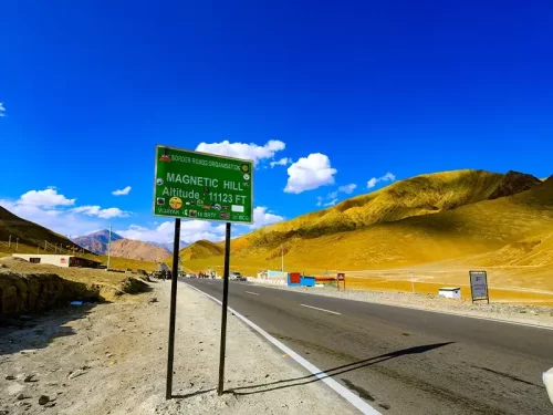
Magnetic Hill is a gravity hill located at an elevation of approximately 3,350 meters (10,991 feet) on the Leh-Srinagar National Highway.

Buddha statue at Alchi Gompa Ladakh in dimly lit shrine during misty weather, featuring multiple arms prayer scarves and wall murals, perfect spiritual Ladakh tour package. Monastery

Alchi Monastery

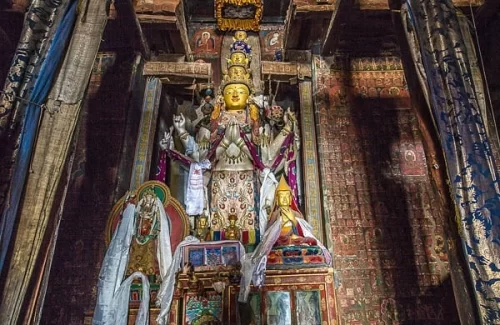
Alchi Monastery is a historic Buddhist temple complex situated at an elevation of approximately 3,100 meters (10,170 feet) on the southern bank of the Indus River.

Stunning Likir Gompa Monastery Ladakh India perched on hillside with white red roofed buildings golden spires amid green poplar trees autumn foliage barren brown mountains blue sky clouds sunset glow, perfect Ladakh tour package. Monastery

Likir Monastery

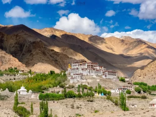
Likir Monastery, or Klu-kkhyil Gompa, is a Tibetan Buddhist monastery of the Gelugpa sect situated at an elevation of approximately 3,500 meters (11,483 feet) near the Indus River.

Frequently Asked Questions About Chang La Pass

Chang La Pass is located in eastern Ladakh on the route between Leh city and Pangong Tso. It stands at an altitude of about 17600 feet and is one of the highest motorable passes in the region.
Chang La Pass can be reached from Leh city by driving toward Karu and continuing on the Pangong Tso route. The journey usually takes around three hours depending on road and weather conditions.
No separate permit is required specifically for Chang La Pass when traveling toward Pangong Tso, but an Inner Line Permit is needed for visiting Pangong Tso and nearby restricted areas. Permits are issued in Leh city.
The best time to visit Chang La Pass in Ladakh is from May to September when the road remains open and weather conditions are relatively stable. Winter access depends on snow clearance by local authorities.
Chang La Pass stands at high altitude where oxygen levels are significantly lower than in Leh city. Short exposure is manageable for most travelers who have properly acclimatized.
There are no permanent hotels at Chang La Pass, but a small army managed tea point is often available during the open season. Travelers should rely on facilities in Leh city for meals and accommodation.
A regular car in good mechanical condition can reach Chang La Pass during the open season as it lies on a maintained road. Careful driving is essential due to steep gradients and occasional icy patches.
Travelers usually spend 10 to 20 minutes at Chang La Pass because of the high altitude and cold winds. Limiting the stay helps reduce the effects of thin air.
Visitors should wear warm layered clothing and carry a windproof jacket when visiting Chang La Pass. Even during summer months temperatures can drop quickly at the summit.
Chang La Pass can sometimes be accessed in winter depending on snowfall and road clearance updates from Leh city authorities. Travel during colder months requires flexibility in planning.
Chang La Pass can be visited by families who are acclimatized to Ladakh conditions. Senior citizens and children should avoid prolonged exposure at the summit due to altitude.
Mobile network coverage at Chang La Pass in Ladakh is generally unavailable or extremely limited. Connectivity becomes more reliable once travelers descend toward Leh city or nearby settlements.

Loved this place ? Let’s Plan Your Ladakh Trip

Get customized Ladakh tour planning designed around altitude comfort, acclimatization time, weather windows, and real Himalayan road conditions. Whether you are visiting for high mountain passes, monasteries, lakes, or remote valley experiences, our exper

⚑ Quick Response | πŸ’° Free consultation | πŸ•’ 24Γ—7 expert support

×

Plan Your Trip