+91 9910402252
admin@chalbanjare.com
| Entry Fee | Free |
| Timings | 06:00 - 18:00 |
| Altitude (m) | 5059 |
| Ideal Visit Duration (hrs) | 0.1 |
| Best Time of Day | Morning |
| Crowd Level | Moderate |
| Distance from Sarchu (km) | 54 |
| Walking Difficulty | Moderate |
| Parking Available | Yes |
| Last Mile Access | Road |
| Suitable for Kids | No |
| Suitable for Seniors | No |
| Wheelchair Friendly | No |
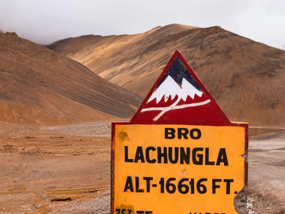
Travelers cross Lachulung La Pass, standing at 16,616 feet, as a vital high-altitude milestone on the journey between Sarchu and Pang. It is a primary transit point for those navigating the Manali-Leh Highway, offering a necessary stop to witness the sheer scale of the Zanskar Range and the transition into the deeper, more desolate terrain of the Ladakh plateau.
The on-ground atmosphere is defined by its rugged, moon-like appearance, featuring ochre-colored ridges and steep scree slopes that lack any significant vegetation. Visitors experience the raw power of the trans-Himalayan environment through biting winds and thin oxygen, creating a sense of being at the edge of the world where the only color comes from the fluttering Buddhist prayer flags at the summit.
Lachulung La is distinct for its position separating the valleys of the Tsarap and Tozay Chu rivers, providing a unique vantage point to view the natural rock-cut canyons and deep gullies formed by centuries of glacial melt. It offers travelers a rare opportunity to spot high-altitude wildlife, such as the Bharal (blue sheep) or Marmots, amidst the desolate limestone formations that make this stretch one of the most geologically fascinating parts of the route.
Lachulung La Pass is a high-altitude mountain crossing situated at an elevation of 5,059 meters (16,598 feet) within the Zanskar Range. Located on the border between Himachal Pradesh and Ladakh along the Leh-Manali Highway, it serves as one of the primary high-altitude gateways for travelers and supply convoys moving toward the Indus Valley.
Geographically, the pass bridges the gap between the Tsarap Chu river valley and the Toozay valley. It is characterized by its rugged, weather-worn rock formations and steep scree slopes, which are the result of centuries of intense cryoturbation and wind erosion in a high-alpine desert environment.
The pass is a vital segment of the ancient trade routes that once connected the Lahaul region with Western Tibet and Central Asia. Today, it remains a critical logistical point managed by the Border Roads Organization (BRO), marking the transition into the higher reaches of the Ladakh plateau. Its extreme altitude and thin air make it a significant physiological milestone for tourists navigating the Trans-Himalayan circuit.
Lachulung La, standing at an elevation of 16,616 feet, is a rugged crossing on the Manali-Leh Highway that remains accessible only during the summer months when the pass is cleared of heavy winter snow. Due to its position between the Sarchu plateau and the Pang plains, it is a high-altitude bottleneck where weather stability is essential for safe transit.
Lachulung La (Lachalung La), standing at an elevation of approximately 5,065m (16,616 ft), is a rugged mountain pass located in the Ladakh region along the Leh-Manali Highway. It serves as a formidable crossing between Sarchu and Pang, characterized by its barren, moon-like landscapes and steep gradients.
Lachulung La, situated at an altitude of 5,065 meters (16,616 feet), serves as a rugged transition point between the Tsarap Chu and Toay Valley. Its photography profile is defined by unique weathered rock pillars and deep ochre-colored canyons that differ significantly from the granite peaks found elsewhere on the Leh-Manali Highway.
 Tourist Attraction
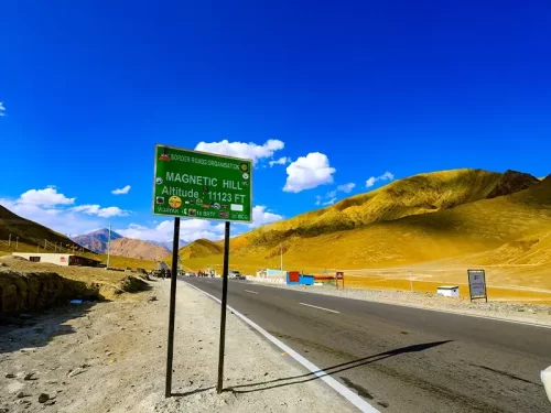
Magnetic Hill is a gravity hill located at an elevation of approximately 3,350 meters (10,991 feet) on the Leh-Srinagar National Highway.
 Monastery
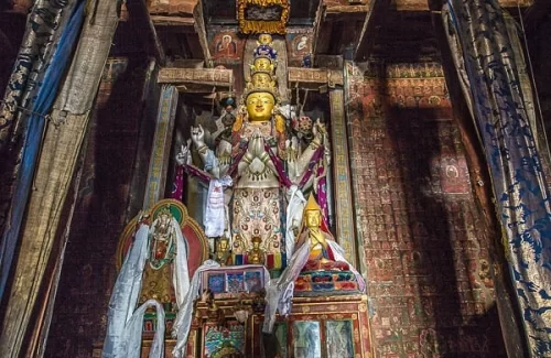
Alchi Monastery is a historic Buddhist temple complex situated at an elevation of approximately 3,100 meters (10,170 feet) on the southern bank of the Indus River.
 Mountain Pass
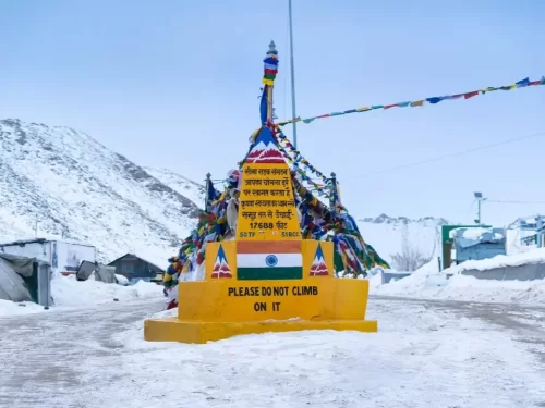
Chang La is a high-altitude mountain pass situated at an elevation of approximately 5,360 meters (17,585 feet) on the road between Leh and Pangong Tso.
Get customized Ladakh tour planning designed around altitude comfort, acclimatization time, weather windows, and real Himalayan road conditions. Whether you are visiting for high mountain passes, monasteries, lakes, or remote valley experiences, our exper
⚡ Quick Response | 💰 Free consultation | 🕒 24×7 expert support

