Tulail Valley Gurez Bandipora Jammu and Kashmir | Remote Himalayan Border Valley

Tulail Valley , Gurez
Tourists visit Tulail Valley to experience an isolated Himalayan landscape with traditional Dard-Shina villages, river valleys, alpine meadows, and minimal modern development, suited for travelers seeking raw terrain and cultural exposure.

Quick Facts About Tulail Valley

Entry Fee Free
Timings 06:00 - 18:00
Altitude (m) 3200
Ideal Visit Duration (hrs) 48
Best Time of Day Morning
Crowd Level Low
Distance from Srinagar (km) 130
Walking Difficulty Moderate
Parking Available No
Last Mile Access Road
Suitable for Kids Yes
Suitable for Seniors No
Wheelchair Friendly No

Why Visit Tulail Valley in Gurez, Kashmir

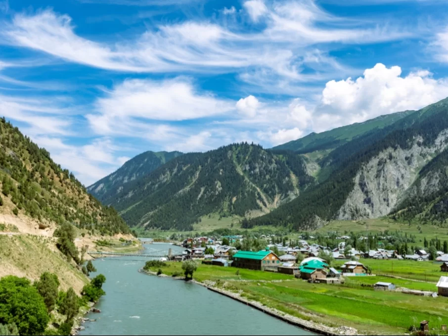
Visitors come to Tulail Valley to experience one of the most remote and least-visited regions of Kashmir, known for its traditional villages, wooden houses, and unspoiled mountain landscapes. It appeals to travelers seeking cultural immersion and raw Himalayan scenery rather than conventional sightseeing.

The on-ground atmosphere is quiet, rural, and deeply connected to daily mountain life, with locals engaged in farming, herding, and seasonal routines. The valley feels slow-paced and isolated, with limited connectivity and a strong sense of distance from urban influence.

What makes Tulail Valley distinct for travelers is its authenticity and isolation, offering a rare look at life along the upper reaches of the Kishanganga River near the Line of Control. It suits experienced travelers who value remoteness, cultural depth, and landscapes that remain largely unchanged by tourism.

History of Tulail Valley, Gurez

Tulail Valley has historically functioned as a remote border valley rather than a political or cultural center. For centuries, it remained sparsely populated due to its harsh winters, high altitude, and limited access, with settlements sustained mainly through subsistence agriculture, livestock rearing, and seasonal movement.

The valley formed part of traditional trans-Himalayan routes linking the Gurez region with areas beyond the Line of Control, facilitating limited trade and pastoral exchange in earlier times. Its geographic isolation meant that large-scale empires and administrative systems had minimal direct influence on daily life in Tulail.

In the modern period, Tulail Valley’s history has been shaped by its strategic location near the border, resulting in long-term restrictions on civilian movement and development. This prolonged isolation preserved the valley’s traditional settlement patterns and landscape, making its historical significance closely tied to geography, survival, and continuity rather than monuments or formal institutions.

Best Time to Visit Tulail Valley

Tulail Valley is best visited during the brief summer season when the high-altitude valley becomes accessible, villages are active, and the natural landscape can be experienced without weather or road-related constraints.
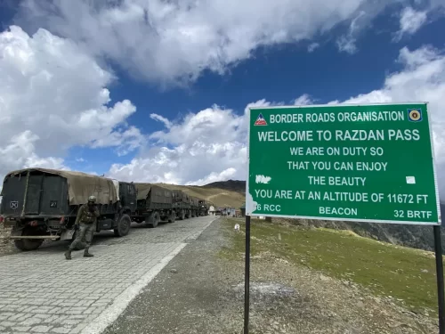
  • Ideal months: June to September, when Razdan Pass is open and regular vehicle movement into the valley is possible.
  • Weather during the best season: Cool to mild daytime temperatures, clear skies, green pastures, and flowing streams, with cold nights typical of the region.
  • Periods to avoid: October to May due to heavy snowfall, closure of Razdan Pass, extreme cold, and complete isolation of the valley during winter months.

How to Reach Tulail Valley, Gurez Region, Jammu and Kashmir

  • Nearest Airport: Srinagar International Airport (Sheikh ul-Alam Airport), approximately 160 km away. Srinagar has regular flights from major Indian cities. From the airport, travel to Tulail Valley is only possible by road via Bandipora and Gurez, taking around 7 to 9 hours depending on road conditions and security checks.
  • Nearest Railway Station: Srinagar Railway Station (Nowgam), about 150 km from Tulail Valley. The station is connected to the Kashmir rail network via Banihal. From here, visitors must hire a private taxi, as there is no direct public transport to Tulail or deeper Gurez villages.
  • Road Access & Last-Mile Connectivity: Tulail Valley is reached via Bandipora and Gurez Valley, crossing Razdan Pass, which remains closed during winter due to heavy snowfall. Roads beyond Dawar toward Tulail are narrow, remote, and partially unpaved, suitable only for experienced local drivers. Private vehicles are required for the last mile. Travel is subject to weather conditions, road status, and security regulations, and visitors should confirm access permissions locally before departure.

What to Expect When You Visit Tulail Valley

  • The environment in Tulail Valley is remote and largely untouched, with narrow river valleys, alpine meadows, wooden villages, and surrounding high mountains. The setting feels quiet and isolated rather than scenic in a curated way.
  • Facilities are minimal. Accommodation options are limited to basic guesthouses or homestays, and shops offer only essential supplies. Medical facilities and ATMs are not available within the valley.
  • Accessibility is challenging and seasonal. The approach involves long mountain drives, and access may be restricted or closed due to weather, landslides, or administrative conditions, especially outside summer months.
  • Movement within the valley is slow and dependent on local roads and walking paths. Distances may appear short on maps but take longer due to road conditions and terrain.
  • Visitor numbers are very low. Most visitors are trekkers, researchers, or travelers seeking isolation, and you should not expect crowds, guided tours, or tourist infrastructure.
  • Weather can be unpredictable, with cold nights even in summer. Electricity supply may be limited or intermittent, and mobile network coverage is weak or absent in many areas.

Important Visitor Information for Tulail Valley, Gurez Region

  • Crowd and Weather Notes: Tulail Valley remains sparsely visited due to its remote location and restricted access. Summers are cool and short, while weather can change rapidly with sudden rain or cold winds even in peak season. The valley remains inaccessible during winter months due to heavy snowfall.
  • Peak and Quiet Visiting Hours: Mid-morning to early afternoon is the safest and most comfortable time to explore the valley, offering better light and clearer mountain views. Early mornings are extremely cold, and evenings see sharp temperature drops.
  • Dress Code: No formal dress code applies, but layered warm clothing is essential even in summer. Modest attire is recommended out of respect for local communities, and sturdy footwear is necessary for walking on uneven village paths.
  • Safety Notes and Practical Cautions: Tulail Valley lies close to the Line of Control, and travel is allowed only with valid permits and local verification. Photography restrictions may apply near sensitive areas. Mobile networks are limited, medical facilities are basic, and travelers should carry essentials and follow local and security advisories strictly.

Photography and Viewpoints at Tulail Valley, Jammu and Kashmir

  • The main viewpoints lie along the Kishanganga River stretch, where wooden houses, terraced fields, and surrounding mountains create strong foreground-to-background compositions.
  • Villages like Burnai, Sheikhpora, and Badwan offer the most authentic frames, with traditional Dard-Shina architecture set against dense forests and alpine slopes.
  • Morning light between 7 am and 10 am is best for village and river photography, as sunlight enters the valley gently and avoids harsh shadows caused by steep mountain walls.
  • Late afternoon light works well for wide valley shots, but sections of the valley fall into shadow early, making timing critical for consistent exposure.
  • Photography is permitted for personal use, but visitors should avoid photographing military installations or checkpoints, which are present along access routes.
  • Crowds are minimal due to limited tourism, but access is seasonal and weather-dependent; road conditions and cloud cover directly affect visibility and shooting opportunities.

Near By Attraction

Welcome sign at Razdan Pass near Gurez during partly cloudy weather, featuring army trucks and mountains, perfect adventure Srinagar tour package.  Mountain Pass

Razdan Pass

Razdan Pass is a high-altitude mountain pass connecting Bandipora to Gurez Valley in Jammu and Kashmir.
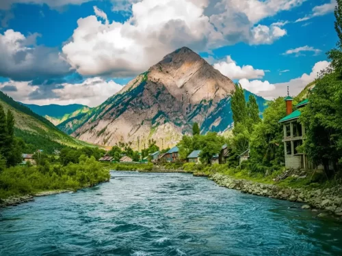
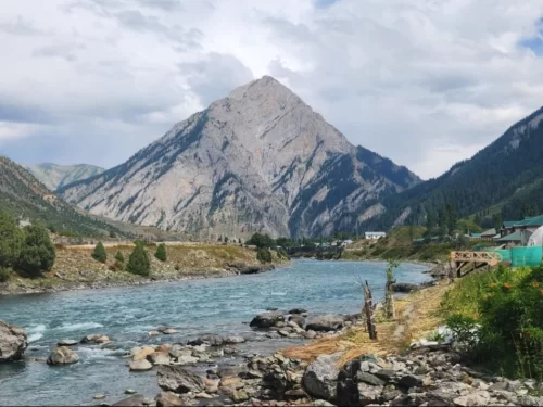
Majestic Habba Khatoon Peak at Gurez Valley during cloudy weather, featuring turquoise river and villages, perfect adventure Srinagar tour package.  Mountain

Habba Khatoon

Habba Khatoon is a distinctive pyramid-shaped mountain peak situated at an elevation of approximately 3,962 meters (13,000 feet) in the Dawar region of Gurez Valley.

Kishanganga River Gurez Valley sunny day, featuring turquoise waters wooden houses poplar trees Habba Khatoon peak mountains, perfect adventure experience Srinagar tour packages. Adventure Park

Kishanganga River

The Kishanganga River, also known as the Neelum River in Pakistan-administered Kashmir, is a significant tributary of the Jhelum River, originating from the high-altitude glaciers near Krishansar Lake and Sonamarg.

Frequently Asked Questions About Tulail Valley

Loved this place ? Let’s Plan Your Jammu and Kashmir Trip

Get customized Jammu and Kashmir tour planning designed around seasonal weather patterns, valley travel routes, snow conditions, and realistic hill road timing. Whether you are visiting for scenic landscapes, serene lakes, spiritual journeys, meadow stays

⚑ Quick Response | πŸ’° Free consultation | πŸ•’ 24Γ—7 expert support

×

Plan Your Trip