Habba Khatoon: Iconic Pyramid Peak and Heritage Site in Gurez Valley, Jammu and Kashmir, India

Habba Khatoon , Gurez
Tourists visit Habba Khatoon to witness one of the most recognizable geographic landmarks in the Kashmir Valley, named after the legendary 16th-century Kashmiri poetess known as the \"Nightingale of Kashmir.\" The site includes the Habba Khatoon Spring (Achura Spring), a crystal-clear freshwater source at the base of the mountain believed by locals to have medicinal properties. The peak serves as a symbol of eternal love and longing, drawing photographers and trekkers who come to explore its slopes, view the surrounding Kishanganga River, and experience the cultural heritage of the Dard-Shin people who preserve the legends of the poetess-queen.

Quick Facts About Habba Khatoon

Entry Fee Free
Timings 06:00 - 18:00
Altitude (m) 4380
Ideal Visit Duration (hrs) 2
Best Time of Day Evening
Crowd Level Moderate
Distance from Dawar (km) 3
Walking Difficulty Hard
Parking Available Yes
Last Mile Access Trek
Suitable for Kids Yes
Suitable for Seniors Yes
Wheelchair Friendly No

Why Visit Habba Khatoon Peak in Gurez Valley

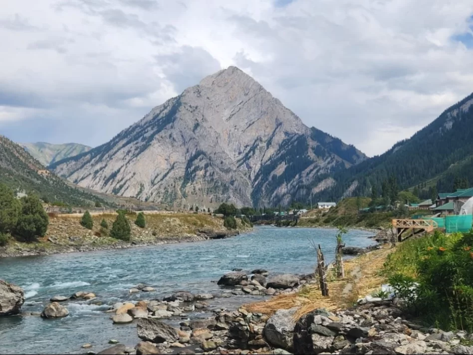
Habba Khatoon is a majestic, pyramid-shaped limestone peak that serves as the iconic silhouette of the Gurez Valley. Travelers visit this mountain not only for its striking geological symmetry but to connect with the poignant history of the 16th-century Kashmiri poetess-queen, Habba Khatoon, who is said to have wandered these slopes in grief after her husband, King Yousuf Shah Chak, was imprisoned by Emperor Akbar. It stands as a powerful symbol of love, loss, and the enduring cultural identity of the region.

The atmosphere at the base of the peak is ethereal, especially during the "golden hour" when the setting sun illuminates the rock face, casting a glow that reflects in the nearby Kishanganga River. Visitors experience a profound sense of stillness while exploring the nearby spring, known as Habba Khatoon’s Spring, where the crystal-clear water is believed to have medicinal properties. The surrounding landscape is a blend of rugged cliffs and soft alpine meadows, creating a dramatic visual contrast that defines the Gurez experience.

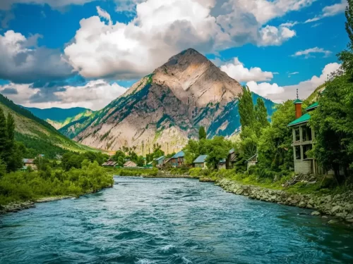
What makes Habba Khatoon distinct is its unique status as a "literary landmark" in the heart of the Trans-Himalayas. Unlike other peaks that are valued solely for their height or climbing routes, this mountain is central to the oral traditions and folk songs of the Dard-Shin and Kashmiri people. It offers a rare vantage point for photographers and trekkers to capture the spiritual essence of Gurez, providing a backdrop that has inspired centuries of poetry and remains the most photographed natural feature in the entire northern frontier.

Historical and Geographic Significance of Habba Khatoon Peak

Habba Khatoon is a majestic, pyramid-shaped limestone peak situated at an elevation of approximately 3,962 meters (13,000 feet) in the Gurez Valley of the Bandipora district. Towering over the central township of Dawar, it is the most iconic geographic landmark of the region and is visible from almost every corner of the valley.

Geographically, the peak is part of the North Himalayan Range and is characterized by its unique triangular silhouette and steep rock faces that change color with the shifting sunlight. At its base, a perennial spring known as the Habba Khatoon spring flows into the Kishanganga River, providing crystal-clear mineral water that is considered sacred and medicinal by the local community. The mountain serves as a natural sentinel, defining the rugged topography of the Gurez borderland.

Historically and culturally, the peak is named after the legendary 16th-century Kashmiri poetess and queen, Habba Khatoon, also known as the "Nightingale of Kashmir." Local lore suggests that she used to wander near this mountain and the spring after her husband, King Yousuf Shah Chak, was exiled by the Mughal Emperor Akbar. The mountain has since become a symbol of love, longing, and the resilient spirit of the Dard-Shin people. Today, it remains a site of immense pride for the inhabitants of Gurez and is a primary attraction for trekkers and travelers seeking to explore the romantic and historical heart of the valley.

Best Time to Visit Habba Khatoon

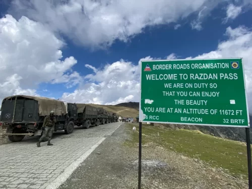
Habba Khatoon, the iconic pyramid-shaped peak standing at approximately 13,000 feet, is the spiritual and geographical anchor of the Gurez Valley. Named after the legendary 16th-century Kashmiri poetess, the mountain and its associated freshwater spring in Achoora village are most accessible during the warmer months when the Razdan Pass remains open, allowing travelers to witness the peak's dramatic shadow over the Kishanganga River.

  • Ideal months: June to September is the peak window; June is particularly striking as the pyramid face of the mountain still holds pockets of snow, while September offers the clearest photography conditions with the peak set against deep blue autumn skies.
  • Weather conditions: Summer daytime temperatures around the base and the spring range from 15°C to 25°C, providing perfect conditions for trekking and sightseeing; however, the mountain creates its own microclimate, and the valley floor can experience sudden, sharp temperature drops as soon as the sun dips behind the massif.
  • Periods to avoid: Strictly avoid travel from December to April when the peak is entirely isolated by the closure of the Razdan Pass; additionally, the peak monsoon weeks of late July and August can bring heavy cloud cover that often obscures the summit for days, potentially disappointing those visiting specifically for the panoramic views.

How to Reach Habba Khatoon Peak

Habba Khatoon is an iconic pyramid-shaped limestone peak that dominates the landscape of the Gurez Valley at an elevation of approximately 4,000m (13,000 ft). Named after the legendary 16th-century Kashmiri poetess and queen, the mountain is the most photographed landmark in northern Kashmir and is famous for the natural spring (Habba Khatoon Spring) that flows at its base.

  • Nearest Airport: Srinagar International Airport (SXR) is the closest air link, located about 125 km away. The drive to the base of the peak in Dawar takes 6 to 7 hours via the Razdan Pass.
  • Nearest Railway Station: Srinagar Railway Station (Nowgam) is the nearest railhead, roughly 135 km away. From the station, travelers must hire a private vehicle or take a shared taxi to Gurez.
  • Road Access and Route: The peak is located just outside the main town of Dawar. After arriving in Dawar, a short 10-15 minute drive on a paved road toward the Kishanganga River brings you directly to the base of the mountain and the famous spring.
  • Last-Mile Connectivity: The base area, including the spring and the viewpoint near the Kishanganga Dam, is easily accessible by any vehicle type. While the peak itself is typically viewed from below, professional trekkers can attempt a steep ascent, which requires local guides and military clearance.
  • Permits and Security: As the peak lies in a sensitive border sector near the Line of Control, travelers must verify their identity at the Dawar army checkpoints. Original Aadhaar cards are mandatory. Photography of the peak is allowed, but travelers must avoid pointing cameras toward any nearby military installations or the dam.
  • Best Viewing Points: The most dramatic views of the peak are from the banks of the Kishanganga River in Dawar or from the JKTDC guest house lawns. The peak turns a brilliant golden hue during sunset, which is highly recommended for photography.
  • Practical Amenities: There are no facilities on the mountain itself. All logistical needs, including food, fuel, and accommodation, must be handled in Dawar village. The Habba Khatoon spring provides fresh mineral water that locals and tourists frequently collect.

Essential Visitor Information for Habba Khatoon MountainClick to open side panel for more information

  • Crowd and Weather: This iconic pyramid-shaped peak is the most famous landmark in the Gurez Valley; it remains uncrowded, though visitors frequently gather at its base in Dawar. The weather is alpine, with cool summers and intense, snowy winters; the peak is often shrouded in clouds during the monsoon months (July–August).
  • Peak and Quiet Visiting Hours: Best viewed at sunrise or sunset when the golden light highlights its unique triangular symmetry; the early morning offers the clearest views before the daily thermal clouds build up around the summit.
  • Dress Code and Preparation: Sturdy trekking boots and windproof layers are necessary if you plan to hike the lower ridges; the terrain is steep and consists of loose shale. Polarized sunglasses are recommended to cut the glare from the limestone rock face and the nearby Kishanganga River.
  • Safety and Practical Cautions: While the base is easily accessible, climbing the peak itself is extremely dangerous and technically challenging; it should not be attempted without professional guidance and prior military clearance. Always keep a safe distance from the Kishanganga River at its base, as water levels fluctuate rapidly due to the dam.
  • Experience-Based Notes: Named after the legendary 16th-century Kashmiri poetess-queen, the mountain is steeped in local folklore; her story of longing and heartbreak is a central part of the Gurez identity. The best photography spots are located along the riverbanks in Dawar or from the Khandiyal Top viewpoint.

What to Expect When You Visit Habba Khatoon

http://googleusercontent.com/map_location_reference/1

The [Habba Khatoon Mountain](http://googleusercontent.com/map_location_reference/0) is the most iconic landmark of the Gurez Valley, standing as a towering pyramid-shaped limestone peak at an altitude of approximately 3,962 meters (13,000 feet). Named after the legendary 16th-century Kashmiri poetess known as the "Nightingale of Kashmir," the mountain is steeped in local folklore and romantic tragedy. Visitors often mention that the peak changes colors during sunrise and sunset, reflecting a golden or orange hue that locals associate with the spirit of the poetess who is said to have wandered these slopes after her separation from King Yusuf Shah Chak.

  • Environment and Surroundings: The mountain dominates the horizon of the central Dawar township and is bordered by the turquoise Kishanganga River. The landscape consists of steep rocky faces, alpine meadows, and dense coniferous forests at its base. Reviewers report that the area is famous for the rare "Kala Zeera" (black cumin), which grows wild on the outskirts of the mountain and is harvested by local villagers.
  • http://googleusercontent.com/map_location_reference/3
  • Facilities and Amenities: There is no infrastructure on the mountain itself, as it is a natural monument. Most amenities, including view-point cafes and basic guesthouses, are located across the river in Dawar or the nearby village of Achoora. A popular spot nearby is the [Habba Khatoon Spring Achoora Gurez](http://googleusercontent.com/map_location_reference/2), where travelers can find a natural freshwater spring believed to have medicinal properties and clear, cold water.
  • Accessibility and Movement: The base of the mountain is easily reachable from Dawar, and the spring is just a short drive or walk away. While the mountain itself is a visual centerpiece, hiking to its higher reaches is extremely challenging due to the steep, rocky gradient and is generally not a common tourist activity. Because the peak is near the Line of Control (LoC), visitors must adhere to military guidelines regarding restricted zones and the strict prohibition of drone photography.
  • Typical Visitor Behavior and Conditions: Most travelers spend their time at the various riverside viewpoints or the spring to capture the mountain's pyramid silhouette in photographs. Cultural storytelling is a significant part of the experience, with local residents often sharing couplets of Habba Khatoon's poetry. The weather remains chilly even in peak summer due to the high elevation, and the area is frequently visited by the local Dard-Shin community during the cumin harvest season.

Capturing the Iconic Symmetry of Habba Khatoon Peak

  • Kishanganga Riverbank Alignment: The premier photography location is the southern bank of the Kishanganga River in Dawar. This low-angle perspective allows for the inclusion of the river as a leading line, framing the pyramid-shaped peak against the sky and capturing its reflection in the glacial water during still mornings.
  • Alpenglow and Sunrise Timing: The peak is best photographed at dawn when the first rays of sunlight illuminate the summit, turning the limestone faces a pale gold. Due to the high surrounding ridges, the "golden hour" is brief; photographers should be in position by 6:00 AM during the summer months to capture the transition from blue hour to sunlight.
  • Habba Khatoon Spring Perspective: Located at the base of the mountain, the natural spring provides a cultural focal point. Photography here allows for a sense of scale, contrasting the small, sacred water source against the massive, sheer rock face of the mountain towering above.
  • Telephoto Compression from Gurez Road: To emphasize the mountain's steep, jagged geometry, use a telephoto lens from the higher elevations of the Bandipora-Gurez road. This compresses the distance between the village of Dawar and the mountain, making the peak appear even more dominant over the local landscape.
  • Prohibited Drone Operations: Habba Khatoon is located within a sensitive frontier zone near the Line of Control (LoC). The use of drones for aerial photography is strictly banned by military authorities. Unauthorized drone flight will result in immediate confiscation of equipment and legal action by local security forces.
  • Seasonal Textures: In early summer (May to June), the remaining snow streaks in the mountain's crevices highlight its geological folds. By late September, the air reaches peak clarity, offering high-contrast shots where the sharp limestone edges stand out vividly against the deep indigo of the high-altitude atmosphere.

Near By Attraction

Welcome sign at Razdan Pass near Gurez during partly cloudy weather, featuring army trucks and mountains, perfect adventure Srinagar tour package.  Mountain Pass

Razdan Pass

Razdan Pass is a high-altitude mountain pass connecting Bandipora to Gurez Valley in Jammu and Kashmir.

Kishanganga River Gurez Valley sunny day, featuring turquoise waters wooden houses poplar trees Habba Khatoon peak mountains, perfect adventure experience Srinagar tour packages. Adventure Park

Kishanganga River

The Kishanganga River, also known as the Neelum River in Pakistan-administered Kashmir, is a significant tributary of the Jhelum River, originating from the high-altitude glaciers near Krishansar Lake and Sonamarg.

Dawar Village Gurez Valley scenic Himalayan village with traditional houses and snow-capped mountains in Kashmir Village

Dawar Village

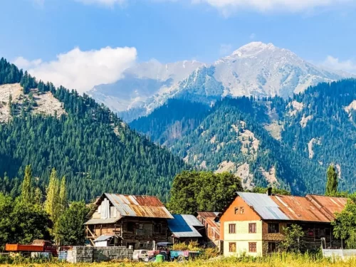
Dawar is the central township and the ancient capital of the Dards, situated at an elevation of approximately 2,400 meters (7,874 feet) along the banks of the Kishanganga River.

Frequently Asked Questions About Habba Khatoon

Habba Khatoon is located in the Gurez Valley region of Jammu and Kashmir, known for its distinct pyramid shaped mountain rising above the Kishanganga River. The peak is a prominent landmark in the valley landscape.
Habba Khatoon can be reached by road from Srinagar via Bandipora and Razdan Pass, and the journey typically takes 8 to 10 hours depending on weather and road conditions. The mountain is visible from various points within Gurez Valley.
The best time to visit Habba Khatoon is between June and September when mountain roads are open and weather conditions are stable. Clear summer days provide better visibility of the surrounding peaks and river valley.
Around two to three hours are generally enough to enjoy views and explore the base area of Habba Khatoon. Full trekking toward higher slopes requires additional time and planning.
Habba Khatoon is suitable for families who prefer scenic viewing from the valley floor. Trekking to higher elevations is better suited for physically prepared travelers.
Habba Khatoon can be visited during winter, but heavy snowfall in Jammu and Kashmir often restricts road access to Gurez Valley. Winter travel requires careful planning and updated road information.
Travelers at Habba Khatoon can enjoy photography, riverside walks, and light trekking near the base area. The experience focuses on natural scenery rather than structured tourist facilities.
Trekking is optional to experience Habba Khatoon from a distance, but reaching higher slopes involves moderate effort and proper preparation. Guided assistance is recommended for longer treks.
Facilities near Habba Khatoon are limited, with basic services available in nearby villages of Gurez Valley. Visitors should not expect developed tourist infrastructure at the site.
Habba Khatoon remains relatively less crowded compared to popular destinations in Jammu and Kashmir. Even during peak months, it offers a peaceful mountain environment.
Habba Khatoon can be combined with visits to other scenic points in Gurez Valley during the same trip. The location fits well into a broader exploration of north Kashmir.
Travelers visiting Habba Khatoon should carry warm layers, water, snacks, and sturdy footwear. Weather in high altitude regions of Jammu and Kashmir can change quickly, so preparation ensures a safer visit.

Loved this place ? Let’s Plan Your Jammu and Kashmir Trip

Get customized Jammu and Kashmir tour planning designed around seasonal weather patterns, valley travel routes, snow conditions, and realistic hill road timing. Whether you are visiting for scenic landscapes, serene lakes, spiritual journeys, meadow stays

⚑ Quick Response | πŸ’° Free consultation | πŸ•’ 24Γ—7 expert support

×

Plan Your Trip