Kishanganga River: trans-Border Himalayan River in Jammu and Kashmir, India

Kishanganga River , Gurez
Tourists visit the banks of the Kishanganga primarily in the Gurez and Tulail valleys, where the river carves through deep gorges and lush alpine meadows. It is a major destination for trout fishing, riverside camping, and photography, particularly near the town of Dawar. The river holds immense strategic and geographic importance as it forms the Line of Control (LoC) at several points, such as Teetwal, where the two sides are separated only by the width of its turquoise waters.

Quick Facts About Kishanganga River

Entry Fee Free
Timings 00:00 - 23:59
Altitude (m) 2400
Ideal Visit Duration (hrs) 48
Best Time of Day Morning
Crowd Level Low
Distance from Srinagar (km) 140
Walking Difficulty Easy
Parking Available Yes
Last Mile Access Road
Suitable for Kids Yes
Suitable for Seniors Yes
Wheelchair Friendly No

Why Visit the Kishanganga River in Gurez Valley

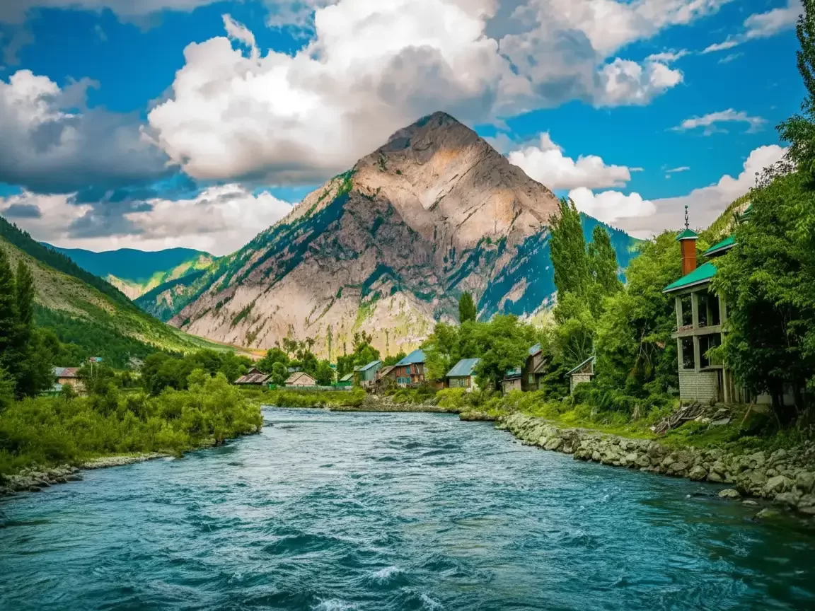
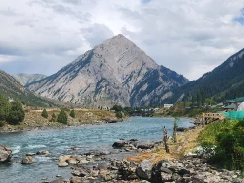
The Kishanganga River, also known as the Neelum River in its lower reaches, is the lifeblood of the Gurez and Tulail valleys, carving a path through some of the most remote and strategically sensitive terrain in the Himalayas. Travelers visit its banks to witness its dramatic, icy-blue waters that originate from the high-altitude glaciers near Dras and flow westward, serving as a natural and historic boundary between different sectors of the high-altitude frontier.

The atmosphere along the river is one of raw, unbridled power combined with alpine tranquility. As it winds through Dawar and Tulail, the sound of its rushing rapids dominates the valley, surrounded by towering pine forests and the distinctive pyramid-shaped peak of Habba Khatoon. Visitors encounter a landscape where the river dictates the rhythm of life, providing essential water for the emerald-green barley fields and serving as a pristine backdrop for the traditional wooden villages of the Dard-Shin people.

What makes the Kishanganga distinct is its dual identity as a serene natural wonder and a centerpiece of regional engineering and history. It offers a rare opportunity for travelers to see a river that remains largely untouched by industrial pollution, providing world-class opportunities for trout fishing and riverside camping in the higher reaches of Gurez. The presence of the Kishanganga Hydroelectric Project near the valley's entrance highlights the river's vital role in modern infrastructure, while its ancient banks continue to whisper stories of the Silk Road travelers who once navigated its rugged canyons.

Historical and Geographic Significance of the Kishanganga River

The Kishanganga River, known as the Neelum River in areas across the Line of Control, is a major Himalayan tributary of the Jhelum River. Originating from the high altitude glacial lakes near Sonamarg, specifically the Krishansar Lake at an elevation of approximately 3,710 meters (12,172 feet), it carves a deep and scenic path through the Gurez Valley in the Bandipora district of Jammu and Kashmir.

Geographically, the river flows through some of the most rugged and remote terrain in the northern Himalayas. It acts as a vital water source for the Gurez and Tulail valleys, supporting high altitude agriculture and a fragile ecosystem home to the rare Himalayan Brown Bear and various trout species. The river's course is characterized by crystal-clear turquoise waters that meander through wildflower meadows and dense coniferous forests, eventually flowing westward toward the Muzaffarabad region.

Historically and strategically, the Kishanganga has been a focal point of regional importance for centuries. It once sat along the ancient trade routes connecting the Kashmir Valley to Central Asia. In modern times, it is the site of the Kishanganga Hydroelectric Project, a major engineering feat that diverts water through a tunnel to a powerhouse in the Bandipora district. The river remains a symbol of the cultural identity of the Dard-Shin people and is increasingly popular for trout fishing and white-water rafting, though its proximity to the border ensures it remains a highly monitored and protected waterway.

Best Time to Visit Kishanganga River

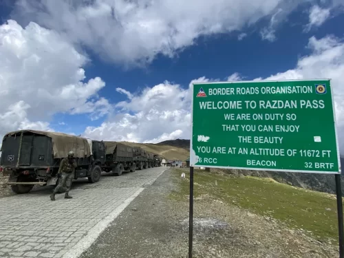
The Kishanganga River, the turquoise lifeline of the Gurez and Tulail valleys, flows at an average altitude of 8,000 feet before crossing the Line of Actual Control. The river's character shifts from a turbulent glacial torrent in early summer to a serene, crystal-clear stream in autumn. Because the river is the primary focus of the Gurez experience, the best time to visit is strictly aligned with the accessibility of the Razdan Pass and the seasonal stability of the riverbanks.

  • Ideal months: June to September is the peak window for riverside activities; June offers the most dramatic water volume from snowmelt, while September provides the clearest turquoise hues and the best conditions for trout fishing (angling).
  • Weather conditions: Summer daytime temperatures near the water range from 15°C to 25°C, though the glacial origin of the river ensures that the immediate air remains crisp; nights along the riverbanks are cold, often dipping to 5°C, requiring heavy layers for campers.
  • Periods to avoid: Avoid travel from November to April when the river is shrouded in deep snow and the valley is inaccessible by road; additionally, be extremely cautious during late July and August, as heavy monsoon rains can cause sudden surges in water levels and make the sandy riverbanks in Tulail dangerously unstable.

How to Reach the Kishanganga River

The Kishanganga River, known as the Neelum River in Pakistan-administered territory, is a trans-border Himalayan river that flows through the Gurez and Tulail valleys of northern Kashmir. It serves as the lifeline for the Dard-Shina community and acts as a natural boundary along various stretches of the Line of Control (LoC), making it one of the most geographically and strategically significant rivers in the region.

  • Nearest Airport: Srinagar International Airport (SXR) is the closest air gateway, located approximately 125 km from the river's main accessible banks in Dawar. The drive from the airport to the river valley takes about 6 to 7 hours via the Razdan Pass.
  • Nearest Railway Station: Srinagar Railway Station (Nowgam) is the nearest railhead, roughly 135 km away. Access beyond Srinagar is strictly by road through Bandipora.
  • Primary Access Points: The river is most easily accessible in Dawar (Gurez), where it flows directly past the main town. For a more remote experience, travelers follow the river upstream for 65 km into the Tulail Valley, passing through villages like Barnoi, Purana Tulail, and finally Chakwali.
  • Road Access and Terrain: The river follows the Bandipora-Gurez road. The stretch from Bandipora to Dawar is paved but involves crossing the high-altitude Razdan Pass. The road leading further into the Tulail Valley along the riverbanks is mostly an unpaved dirt track, requiring high-clearance vehicles or 4x4 SUVs.
  • Last-Mile Connectivity: While the river is visible from the road for most of the journey, specific spots for photography or permissible riverside walks are found in Dawar and Bagtore. Local shared taxis (Sumos) from Bandipora provide the most consistent transport for those not using private vehicles.
  • Security and Restricted Areas: Because the Kishanganga River flows extremely close to the LoC, certain banks are strictly off-limits. Travelers must stay within designated tourist zones in Dawar and Tulail. Photography of bridges, dams, or military installations along the river is strictly prohibited. Original Aadhaar cards are mandatory for verification at multiple army checkpoints along the river route.
  • Seasonal Accessibility: Access to the river valley is restricted to the summer months (May to October). During winter, the heavy snow at Razdan Pass cuts off all road access to the Kishanganga basin, and the river itself may partially freeze in the higher reaches of Tulail.

Overview of the Kishanganga River

The Kishanganga River, also known as the Neelum River after it crosses the Line of Control (LoC) into Pakistan-administered territory, is a vital Himalayan waterway flowing through the Gurez and Tulail valleys of North Kashmir. Renowned for its distinctive turquoise waters and glacial clarity, the river originates in the high-altitude mountains near Krishansar Lake and serves as the cultural and economic lifeline for the Dard-Shin community. Organize your visit around these key themes:

Riverside Experiences and Natural Beauty

The river defines the landscape of the Gurez Valley, offering serene environments that are virtually untouched by mass tourism. The banks are lined with willow groves, pebble beaches, and traditional wooden hamlets.
  • Turquoise Waters: Visitors often remark on the river's striking deep blue and turquoise hues, which are most vibrant under clear midday sun.

What to Expect When You Visit the Kishanganga River

http://googleusercontent.com/map_location_reference/1

The [Kishenganga River](http://googleusercontent.com/map_location_reference/0) is the lifeline of the Gurez Valley, known for its stunning turquoise waters and significant role in the local Dard-Shin culture. Originating near Dras, it flows through the high-altitude landscapes of Gurez and Tulail before crossing the Line of Control (LoC) into Pakistan-administered Kashmir, where it is known as the Neelum River.

  • Environment and Surroundings: The river is characterized by its crystal-clear, icy-blue water and fast-moving currents. It flows through a dramatic landscape of lush green meadows, dense coniferous forests, and steep rocky cliffs. The iconic pyramid-shaped Habba Khatoon peak provides a majestic backdrop as the river passes through the main town of Dawar.
  • Facilities and Amenities: Recreational infrastructure directly along the riverbanks is minimal to preserve its natural state. You will find basic wooden bridges and occasional riverside campsites or small parks in and around Dawar. Most amenities, including guesthouses and local eateries, are located within the nearby villages rather than on the river itself.
  • Accessibility and Movement: The river is easily accessible from various points throughout the Gurez and Tulail valleys. In Dawar, visitors can walk right down to the riverbanks. However, certain stretches are highly restricted due to their extreme proximity to the Line of Control. Travelers must adhere to all signage and military instructions regarding restricted zones and photography.
  • Typical Visitor Behavior and Conditions: The river is a primary site for relaxation, photography, and trout fishing (which requires a specific permit from the Fisheries Department). Visitors often spend time sitting by the banks in the evening to enjoy the serene atmosphere. Because it is a glacial-fed river, the water temperature remains near freezing even in peak summer, and the current can be dangerously swift, so swimming is generally not recommended.

Capturing the Glacial Beauty of the Kishanganga River

  • Habba Khatoon Reflection Point: The most sought-after shot is located along the riverbanks near Dawar, where the calm morning waters provide a near-perfect mirror image of the Habba Khatoon peak. Arrive between 6:30 AM and 7:30 AM to capture the first light hitting the summit while the river remains in soft, even shadow.
  • Turquoise Water Clarity: To highlight the river's distinct teal-blue hue, photograph from an elevated position on the Gurez-Tulail road during midday. The high-angle sun penetrates the water, revealing the white boulder-strewn bed and the vibrant glacial color that is often lost in low-light conditions.
  • Tulail Valley Meanders: In the upper reaches toward Chakwali, the river snakes through wide alpine meadows. Use a wide-angle lens to document the serpentine curves of the water against the backdrop of terraced barley fields and traditional wooden Shina settlements.
  • Long-Exposure Opportunities: The rocky cascades near the hydroelectric project area provide excellent subjects for long-exposure photography. Using a neutral density filter during the late afternoon allows for "silky" water effects that contrast sharply against the rugged, dark Himalayan granite.
  • Strategic Border Restrictions: Large sections of the Kishanganga River act as the de facto Line of Control (LoC). Photography is strictly prohibited in areas where the opposite bank is not under Indian administration. Avoid framing any bridges, dams, or military bunkers that line the river's course, as these are sensitive security installations.
  • Seasonal Volume Shifts: The river’s character changes dramatically by season. Late spring (May–June) offers high-volume, turbulent white water ideal for action shots, while the autumn months (September–October) feature lower, crystal-clear flows that emphasize the tranquility of the Gurez Valley.

Near By Attraction

Welcome sign at Razdan Pass near Gurez during partly cloudy weather, featuring army trucks and mountains, perfect adventure Srinagar tour package.  Mountain Pass

Razdan Pass

Razdan Pass is a high-altitude mountain pass connecting Bandipora to Gurez Valley in Jammu and Kashmir.

Majestic Habba Khatoon Peak at Gurez Valley during cloudy weather, featuring turquoise river and villages, perfect adventure Srinagar tour package.  Mountain

Habba Khatoon

Habba Khatoon is a distinctive pyramid-shaped mountain peak situated at an elevation of approximately 3,962 meters (13,000 feet) in the Dawar region of Gurez Valley.

Dawar Village Gurez Valley scenic Himalayan village with traditional houses and snow-capped mountains in Kashmir Village

Dawar Village

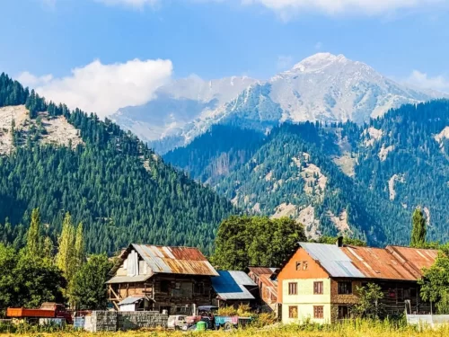
Dawar is the central township and the ancient capital of the Dards, situated at an elevation of approximately 2,400 meters (7,874 feet) along the banks of the Kishanganga River.

Frequently Asked Questions About Kishanganga River

Kishanganga River flows through the Gurez Valley region of Jammu and Kashmir, running close to the Line of Control and surrounded by high mountain ranges. It is one of the major rivers in north Kashmir.
Kishanganga River can be reached by road from Srinagar via Bandipora and Razdan Pass, and the journey usually takes 8 to 10 hours depending on weather and road conditions. The river runs alongside villages and open valleys in Gurez.
The best time to visit Kishanganga River is between June and September when mountain roads are open and weather conditions are stable. Clear summer days offer better views and comfortable outdoor exploration.
Kishanganga River is suitable for families who prefer scenic riverside walks and calm outdoor experiences. Visitors should maintain safe distance from the flowing water due to natural currents.
Travelers at Kishanganga River can enjoy photography, short riverside walks, and relaxation by the water. The experience focuses on natural landscapes rather than commercial water sports.
One to two hours are generally enough to spend near Kishanganga River at a relaxed pace. Many visitors include it as part of a broader valley exploration.
Kishanganga River can be visited during winter if access roads remain open, but heavy snowfall in Jammu and Kashmir often restricts travel to the Gurez region. Winter conditions require careful planning.
Photography is allowed at Kishanganga River for personal use. The combination of flowing water, mountain backdrops, and open valley landscapes makes it suitable for scenic photography.
Facilities near Kishanganga River are limited to small local establishments in nearby villages. Visitors should not expect developed tourist infrastructure along the riverbanks.
Kishanganga River remains relatively less crowded compared to mainstream tourist areas. Even during summer months, it offers a peaceful and open environment.
Kishanganga River can be combined with visits to Habba Khatoon and other scenic spots in Gurez Valley during the same trip. The river flows through key sightseeing points in the region.
Travelers visiting Kishanganga River should carry water, warm clothing, and sturdy footwear. Weather in this high altitude region of Jammu and Kashmir can change quickly, so preparation ensures a safe visit.

Loved this place ? Let’s Plan Your Jammu and Kashmir Trip

Get customized Jammu and Kashmir tour planning designed around seasonal weather patterns, valley travel routes, snow conditions, and realistic hill road timing. Whether you are visiting for scenic landscapes, serene lakes, spiritual journeys, meadow stays

⚑ Quick Response | πŸ’° Free consultation | πŸ•’ 24Γ—7 expert support

×

Plan Your Trip