Siang Riverfront in Pasighat, East Siang, Arunachal Pradesh, India

Siang Riverfront , Aalo
Tourists visit the riverfront, particularly at access points like Komlighat and Raneghat, for panoramic views of the river as it emerges from the mountains into the plains. The area is a hub for adventure activities including Grade III and IV white-water rafting, kayaking, and angling for Golden Mahseer, while also serving as a major community gathering spot for local Adi festivals and sunset photography.

Quick Facts About Siang Riverfront

Entry Fee Free
Timings 06:00 - 18:00
Altitude (m) 300
Ideal Visit Duration (hrs) 3
Best Time of Day Morning
Crowd Level Low
Distance from City Centre (km) 5
Walking Difficulty Moderate
Parking Available Yes
Last Mile Access Walk
Suitable for Kids Yes
Suitable for Seniors Yes
Wheelchair Friendly No

Why Visit the Siang Riverfront: A Hub for Adventure and Ecology

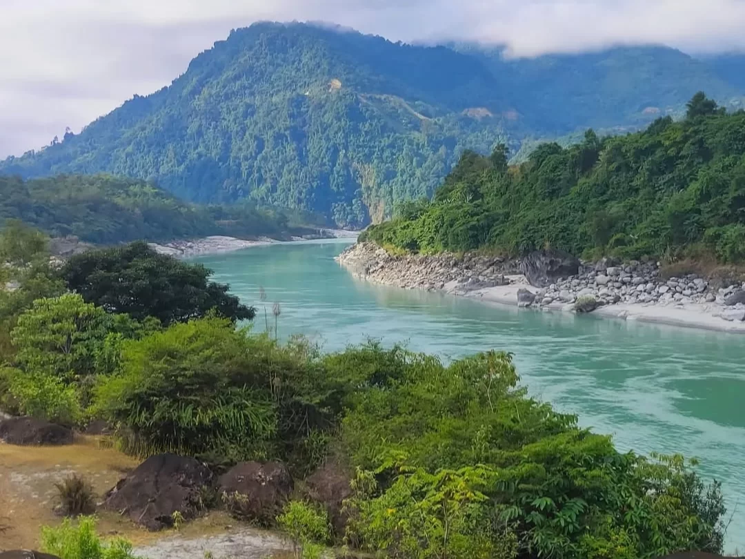
The Siang Riverfront draws travelers for its status as one of the world’s premier destinations for big-volume whitewater rafting and kayaking. As the Brahmaputra’s main artery through the Himalayas, this corridor attracts those looking to navigate legendary Class IV and V rapids or explore the untouched riverbanks that serve as a critical ecological link between high-altitude peaks and the plains of Assam.

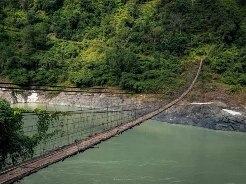
The atmosphere along the riverfront is defined by raw, primordial energy where the thunderous roar of the water meets the silence of dense tropical rainforests. On-ground, the experience is tactile and rugged: travelers cross high, swaying cane and bamboo suspension bridges, camp on vast white sand beaches that shift with the seasons, and encounter the Adi people, whose lives remain deeply synchronized with the river’s unpredictable cycles.

What makes the Siang Riverfront distinct is its sheer scale and the opportunity for deep-interior exploration. Unlike more commercialized river circuits, the Siang offers a wilderness experience where the infrastructure is almost entirely natural; the convergence of the Siang, Yamne, and Yang Sang Chu rivers creates a unique microclimate and a biodiversity hotspot that remains one of the few places in Asia where a river’s entire natural course can be witnessed in such a wild state.

Significance and Ecosystem of the Siang Riverfront

The Siang Riverfront in Aalo represents a vital geographical corridor where the Siyam and Sipu rivers converge before eventually joining the Brahmaputra system. This waterfront is ecologically significant as part of the eastern Himalayan biodiversity hotspot, characterized by its high-velocity currents and the surrounding tropical evergreen forests. Historically, the river has dictated the settlement patterns of the Galo and Adi tribes, serving as both a natural defense barrier and a primary source for subsistence fishing and traditional water management.

The cultural relevance of the riverfront is centered on the indigenous engineering of cane and bamboo suspension bridges, which demonstrate a sophisticated understanding of local materials and tension-based construction. These bridges are not merely functional crossings but symbols of communal labor and tribal connectivity. For visitors, the riverfront provides a direct look at the "Donyi-Polo" philosophy of nature worship, as the water remains a sacred element in local rituals and a primary site for the Mopin festival's purification ceremonies.

Best Time to Visit Siang Riverfront: A Seasonal Guide for Adventure and Culture

The Siang Riverfront near Pasighat is a dynamic landscape that shifts from a turquoise, crystal-clear sanctuary in winter to a powerful, silt-laden giant during the monsoon. For travelers, the window for visiting is strictly defined by the river’s water levels, which dictate whether the banks are accessible for camping and festivals or submerged under the weight of Himalayan runoff.

  • Ideal Months: October to April is the peak window, with November and December being the absolute best for the Siang River Festival and white-water rafting expeditions.
  • Weather Conditions: Expect bright, fog-free days with temperatures between 12°C and 25°C. The "Siberian High" winds keep the skies exceptionally clear, providing sharp visibility of the surrounding hanging bridges and the Eastern Himalayan foothills.
  • Periods to Avoid: June to September must be avoided for riverfront activities; the Siang is prone to sudden, massive swells and the region receives some of the highest rainfall in India, which frequently triggers road-blocking landslides and renders the sandy riverbanks inaccessible.

How to Reach Siang Riverfront: A Practical Travel Guide

The Siang Riverfront, located at Pasighat in the East Siang district of Arunachal Pradesh, is the gateway to one of the most powerful river systems in the Himalayas. Reaching this scenic destination involves a journey through the plains of Upper Assam and into the foothills of the eastern Himalayas.

  • Nearest Airport: Pasighat Airport (IXT) is the closest domestic airstrip, located just 3 km from the town center; however, commercial flight frequency is limited. For more reliable connectivity, travelers typically use Dibrugarh Airport (DIB) in Assam (approx. 155 km away). From Dibrugarh, the drive to Pasighat takes about 4–5 hours via the Bogibeel Bridge.
  • Nearest Railway Station: Murkongselek Railway Station (MZS) in Jonai, Assam, is the closest railhead, situated roughly 35 km from the Siang Riverfront. Daily Intercity Express trains from Guwahati arrive here, and the onward journey to Pasighat can be completed in about 45–60 minutes by shared or private taxi.
  • Road Access & Last-Mile Connectivity: Pasighat is well-connected via NH-15 and NH-515. Regular Arunachal Pradesh State Transport (APSTS) buses and private "Line Sumos" operate daily from Itanagar (260 km), Guwahati, and Lakhimpur. Within Pasighat, the riverfront area (Komlighat) is easily accessible via local e-rickshaws or auto-rickshaws from the main market.
  • Water Transport Option: A unique alternative route involves taking a ferry across the Brahmaputra from Dibrugarh to Oryamghat, followed by a 25 km bus or taxi ride to reach Pasighat.
  • Realistic Travel Conditions: Road conditions are generally good on the national highways, but mountain stretches can be prone to landslides during the monsoon (June–September). An Inner Line Permit (ILP) is mandatory for Indian citizens and must be produced at the Ruksin or Likabali check posts.

Traveler Tip: Visit during the Solung Festival or between October and April for the best weather. If you are planning for river rafting, ensure you book with certified operators in advance, as the Siang's rapids are highly technical.

What to Expect When You Visit Siang Riverfront

  • Environment and Surroundings: The riverfront is characterized by the powerful, emerald-green currents of the Siang River (the Brahmaputra in its upper reaches) and a dramatic landscape of steep gorges and dense tropical rainforest. Weather is unpredictable; while winters (October to February) offer clear skies and receding water levels, the monsoon season (June to September) brings high humidity and heavy rains that cause the river to swell significantly, often turning the water murky with silt.
  • Facilities and Amenities: Infrastructure at the riverfront is minimal and rugged. Near Pasighat, there are basic concrete viewpoints and stepped access in some areas, but most of the riverfront remains in its natural state without paved walkways or public restrooms. While local operators provide high-quality safety gear for white-water rafting, visitors should not expect commercial food stalls or equipment rentals directly on the banks; all essentials must be carried from the main town.
  • Accessibility and Movement: Access points vary from easily reachable banks near Pasighat (15-30 minutes by car) to extremely remote sections in Upper Siang accessible only via multi-day trekking or specialized 4x4 vehicles. The riverbank terrain is often composed of large, slippery boulders and loose sand, making movement difficult for those with mobility issues. During the monsoon, many riverside paths become impassable due to landslides or rising water levels.
  • Typical Visitor Behavior and Conditions: The riverfront is a dual-use space; it is a hub for high-adrenaline adventure sports like Grade III to V rafting and a sacred site for the indigenous Adi tribe. Visitors are expected to maintain a quiet and respectful presence near traditional fishing spots and tribal villages. It is standard for locals to use the river for daily chores and ritual dips, so conservative behavior and seeking permission before photography are required to respect community privacy.

Essential Visitor Information for the Siang Riverfront: Expert Insights

  • Weather & Water Conditions: The prime visiting window is from October to April when the river is a clear turquoise and currents are manageable. During the monsoon (June to September), the Siang transforms into a high-turbidity, brown surge that makes the riverfront hazardous and suspends all rafting or angling activities.
  • Peak & Quiet Hours: Sunrise (approx. 06:00) and sunset (16:30–17:30) are the "golden hours" for photography and viewing the Himalayas. Midday often brings high heat and haze, reducing visibility across the river valley. For solitude, avoid the riverfront during the Siang River Festival in November/December, when Komlighat becomes heavily crowded.
  • Dress Code & Gear: There is no formal dress code, but quick-drying outdoor apparel and sturdy, slip-resistant water shoes are essential for the rocky banks. If visiting in winter (December–January), pack heavy layers as temperatures drop significantly after sunset near the water.
  • Safety & Practical Cautions: The Siang is immensely powerful with hidden eddies; never attempt to swim in the main channel. Use only licensed operators for water sports, and always wear a life jacket. Be aware that this is a high-seismic zone (Zone V); stay alert for sudden changes in water levels or clarity, which can indicate upstream landslides or blockages.

Capturing the Mighty Siang: Prime Viewpoints and Photography Guide

  • Komlighat Riverfront: This is the most accessible and popular ground-level spot in Pasighat. It offers a sprawling view of the riverine beach and the massive width of the Siang. For the best shots of the turquoise water against white sand, shoot during the Winter months (November to February). Early morning Blue Hour provides a serene, misty atmosphere ideal for minimalist landscape compositions.
  • Raneghat Suspension Bridge: This architectural landmark provides a high-angle perspective of the river’s powerful current as it enters the plains. From the center of the bridge, you can capture the symmetrical leading lines of the cables against the vast horizon. Use a wide-angle lens here to emphasize the scale of the valley and the distant snow-capped Himalayan peaks visible on clear winter days.
  • Bodak Scenic Area: Located about 15km from the main town along the highway, this elevated area offers a dramatic "birds-eye" view of the Siang’s meanders. It is the premier location for Sunset photography, as the sun dips behind the western ridges, casting a golden hue over the braided river channels. The contrast between the lush green hills and the bright river sand is particularly striking here.
  • The Buddhist Temple (Gompa) Overlook: Situated on a small hillock near the airstrip, the temple grounds provide a peaceful vantage point overlooking the river and the Pasighat town skyline. The Golden Hour (16:00 – 17:00) is the best time for photography, as the warm light hits the temple’s colorful architecture and the river simultaneously.
  • Photography Rules and Access: There are currently no official permits required for amateur photography at the public ghats or bridges. However, photography near the Pasighat Airport (ALG) and sensitive military installations is strictly prohibited. Avoid using drones near the airstrip or the Raneghat Bridge without prior clearance from the District Administration, as these are considered sensitive zones.
  • Crowd and Safety Factors: Komlighat becomes heavily crowded with locals during the Siang River Festival and on Sunday evenings. For unobstructed landscape shots, plan your visit on weekday mornings. During the monsoon (June to August), the riverfront can be hazardous due to rapid rises in water levels; maintain a safe distance from the edge and avoid walking onto the sandy mid-river islands which can become submerged quickly.

Near By Attraction

Along Hanging Bridge over Siang River in Aalo, Arunachal Pradesh surrounded by lush green hills suspension bridge

Along Hanging Bridge

The Along Hanging Bridge is a traditional suspension structure constructed of bamboo and cane that spans the Siyom River.

Patum Bridge historic suspension bridge connecting scenic green hills and river landscape in Arunachal Pradesh Tour Package. suspension bridge

Patum Bridge

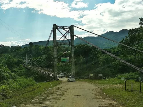
Patum Bridge in Aalo, West Siang, Arunachal Pradesh, India Patum Bridge is a 146-meter-long cable-stayed suspension bridge that spans the Yomgo River (Siyom River) near the town of Aalo.

Aalo Town scenic hill destination in Arunachal Pradesh surrounded by lush green mountains and serene landscapes Arunachal Pradesh Package. Hill Station

Aalo Town

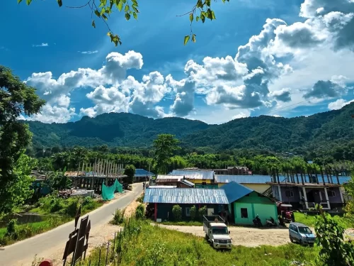
Aalo is a valley town and the administrative headquarters of the West Siang district, located at the junction of the Sipu and Siyom rivers.

Frequently Asked Questions About Siang Riverfront

Siang Riverfront is located in Pasighat in East Siang district of Arunachal Pradesh along the banks of the Siang River. It serves as a scenic riverside area for visitors and locals.
Siang Riverfront can be reached within 10 to 15 minutes by road from Pasighat town center by taxi or local vehicle. Some sections are accessible by short walks from nearby roads.
The best time to visit Siang Riverfront is between October and April when the weather remains pleasant and river conditions are more stable. Monsoon months bring heavy rainfall and stronger currents.
Siang Riverfront is popular for wide river views sunset scenery and relaxed evening walks. Many travelers visit for photography and short leisure breaks.
Siang Riverfront is suitable for family visits during daytime as access involves minimal walking. Visitors should remain cautious near the riverbank due to uneven surfaces.
There are hotels and guesthouses available in Pasighat near Siang Riverfront. Most travelers stay in town and visit the riverfront as part of their itinerary.
Siang Riverfront has limited facilities depending on the exact stretch visited. Basic amenities such as restaurants and shops are available in nearby parts of Pasighat.
Most travelers spend one to two hours at Siang Riverfront enjoying the river view and relaxed atmosphere. It is commonly included as a short stop in a Pasighat sightseeing plan.
Siang Riverfront may become difficult to access safely during peak monsoon season due to rising water levels. Checking local weather conditions before visiting is advisable.
Travelers visiting Siang Riverfront should carry drinking water comfortable footwear and light sun protection. Staying at a safe distance from strong currents is important for safety.

Loved this place ? Let’s Plan Your Arunachal Pradesh Trip

Get customized Arunachal Pradesh tour planning designed around mountain road distances, permit requirements, seasonal weather windows, and realistic travel pacing. Whether you are visiting for monasteries, high-altitude passes, river valleys, tribal cultu

⚑ Quick Response | πŸ’° Free consultation | πŸ•’ 24Γ—7 expert support

×

Plan Your Trip