Patum Bridge in Aalo, West Siang, Arunachal Pradesh, India

Patum Bridge , Aalo
Visitors frequent this bridge to obtain panoramic, unobstructed views of the Aalo valley, the surrounding Eastern Himalayan foothills, and the river below. It is a significant local landmark known for its illuminated night-time display and serves as a vital infrastructure link for vehicular and pedestrian traffic between Aalo and neighboring villages.

Quick Facts About Patum Bridge

Entry Fee Free
Timings 00:00 - 23:59
Altitude (m) 300
Ideal Visit Duration (hrs) 1
Best Time of Day Evening
Crowd Level Moderate
Distance from City Centre (km) 4
Walking Difficulty Easy
Parking Available Yes
Last Mile Access Road
Suitable for Kids Yes
Suitable for Seniors Yes
Wheelchair Friendly No

Why Visit Patum Bridge: The Best Vantage Point of Aalo

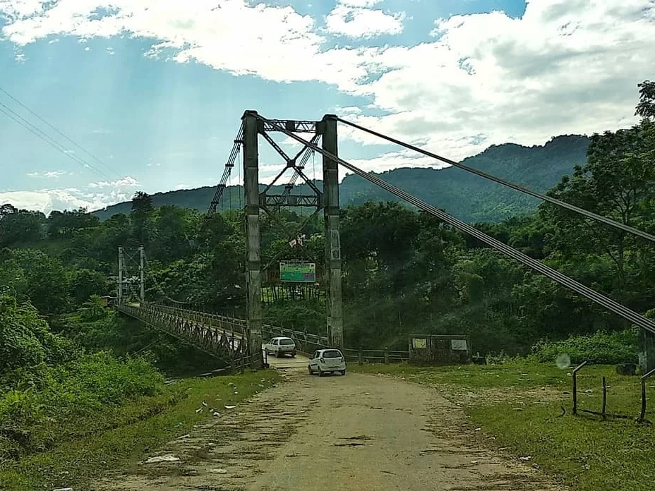
Visitors come to Patum Bridge to secure the most comprehensive panoramic views of Aalo town and the sprawling West Siang valley. Spanning 146 meters over the Yomgo River, this modern cable-stayed bridge serves as a vital artery for local transport while doubling as a premier photography spot for travelers capturing the convergence of the Sipu and Siyom rivers against a backdrop of distant Himalayan peaks.

The on-ground atmosphere at the bridge is a blend of local utility and quiet observation, especially during the "golden hour" when the sun sets behind the surrounding hills. Unlike the traditional cane and bamboo hanging bridges nearby, Patum provides a stable, elevated platform where the roar of the turquoise Yomgo River below creates a constant acoustic backdrop to the sight of local Galo commuters and the evening glow of the bridge's own illumination.

What makes Patum Bridge distinct is its role as a literal and metaphorical bridge between the rugged tribal landscapes and the administrative hub of Aalo. It offers a rare perspective of the town's geography that is otherwise hidden by the dense valley vegetation, providing an accessible way to witness the sheer scale of the river's path and the seasonal transformation of the snow-capped mountains that frame the northern horizon.

Engineering and Regional Connectivity of Patum Bridge

Patum Bridge serves as a critical infrastructure link spanning the Yomgo (Siang) River, connecting Aalo with the surrounding high-altitude settlements of West Siang. As one of the longest steel cable suspension bridges in the region, it represents a significant transition from traditional cane-and-bamboo craftsmanship to modern permanent engineering. Its construction was essential for the logistical integration of remote tribal villages, facilitating the movement of local produce and essential services across the volatile river currents.

The bridge provides a strategic vantage point for observing the confluence of the Sipu and Siyam rivers, a site of immense geographical importance in the Arunachal landscape. For travelers, the structure is the primary gateway to the hinterlands of the Galo people, offering a literal and symbolic passage between the urban center of Aalo and the ancestral agricultural lands. The bridge is a vital node for local transit, reflecting the modernization of ancient trade routes that have historically defined the economic survival of the valley's inhabitants.

Best Time to Visit Patum Bridge: A Seasonal Guide for Aalo

Patum Bridge, a vital suspension link over the Yomgo (Siyom) River, is best visited when the river is a clear, serene turquoise and the surrounding valley is bathed in the gentle light of the dry season. As a focal point for photography and local life in Aalo, the bridge’s accessibility and the safety of the walking deck are heavily dependent on avoiding the region's intense and volatile rainfall cycles.

  • Ideal Months: October to April is the optimal window. Visiting in early April is particularly rewarding as it coincides with the Mopin Festival, the most significant harvest celebration of the Galo tribe.
  • Weather Conditions: Expect crisp, fog-free days with visibility extending to the distant Himalayan foothills. Daytime temperatures range from 12°C to 24°C, providing a comfortable climate for walking across the bridge and exploring the adjacent riverside trails.
  • Periods to Avoid: June through September must be avoided due to the monsoon, which causes the Yomgo River to swell dangerously close to the bridge structure and makes the wooden or bamboo decking extremely slippery. Additionally, heavy summer rains often lead to road blockages between Pasighat and Aalo, making the bridge physically unreachable for days at a time.

How to Reach Patum Bridge: Travel & Logistics Guide

Patum Bridge is a vital suspension link over the Siang River, located near Aalo in the West Siang district of Arunachal Pradesh. Accessing this remote engineering marvel requires navigating the Trans-Arunachal Highway via the gateway towns of Pasighat or Silapathar.

  • Nearest Airport: Pasighat Airport (IXT) is the closest domestic terminal (approx. 100 km), though flights are infrequent. Most travelers fly into Dibrugarh Airport (DIB) in Assam (approx. 200 km). From Dibrugarh, the journey involves crossing the Bogibeel Bridge and a 6–7 hour mountain drive via the Likabali-Basar road.
  • Nearest Railway Station: Silapathar Railway Station in Assam is the most practical railhead, located about 145 km from the bridge. Frequent shared taxis (Sumos) and private vehicles operate from Silapathar to Aalo, passing through the Himalayan foothills.
  • Road Access & Last-Mile Connectivity: The bridge is situated approximately 25–30 km from Aalo town. It is accessible via the Aalo-Pangin road. There is no dedicated public transit to the bridge itself; travelers must hire a private taxi from Aalo market or use a shared Sumo heading toward Pasighat or Pangin and request a drop-off at the bridge junction.
  • Travel Permits: Entry requires a valid Inner Line Permit (ILP) for Indian nationals or a Protected Area Permit (PAP) for foreigners. These are strictly checked at the Likabali or Ruksin entry gates.
  • Realistic Travel Conditions: The road from Aalo to Patum Bridge is winding and can be impacted by monsoon rains (June–September), which often lead to slushy patches or minor landslides. Mobile network connectivity (especially 4G/5G) is highly unstable at the riverfront; it is advisable to pre-arrange return transport.

Traveler Tip: Visit during the early morning or late afternoon for the best photography light over the Siang River. Ensure your vehicle has high ground clearance, as the approach roads to the riverbanks can be uneven.

What to Expect When You Visit Patum Bridge

  • Environment and Surroundings: This 146-meter cable-stayed bridge spans the Yomgo (Siyom) River, offering panoramic views of the Aalo valley and distant snow-capped Himalayan peaks. The environment is tranquil, though wind speeds on the bridge deck can be high. During the monsoon (June–September), the river below becomes turbulent and chocolate-brown with silt, while the winter months (November–February) provide clear, emerald-green water and misty morning vistas.
  • Facilities and Amenities: There are no commercial facilities such as restrooms, cafes, or ticket booths at the bridge itself. It is a functional piece of public infrastructure used for local vehicle transportation. Modern lighting was recently installed, making it one of the few local landmarks accessible for evening viewing, but visitors must carry their own water and supplies from Aalo town, located approximately 15 minutes away by car.
  • Accessibility and Movement: Unlike the traditional bamboo "hanging bridges" nearby, Patum Bridge is a sturdy steel and concrete structure that accommodates both vehicles and pedestrians. The road leading to the bridge is paved but narrow, and the pedestrian walkways on either side of the bridge deck are narrow; visitors should remain vigilant of passing local traffic and motorcycles. The surface can become extremely slippery during and after rain.
  • Typical Visitor Behavior and Conditions: The bridge serves as a major photographic landmark, especially during "golden hour" and sunset. While photography is permitted, visitors must not obstruct the flow of local traffic or commuters. It is common to see local residents using the bridge for evening walks. There is no entry fee, but travelers are expected to adhere to a "no littering" policy, as there are no active waste management services on-site to handle tourist trash.

Essential Visitor Information for Patum Bridge: Expert Insights

  • Crowd & Weather Realities: The bridge is most atmospheric during the dry season (October to April) when the Yomgo River below is clear. During monsoons, the bridge can be slippery and the surrounding area prone to leeches and thick mud.
  • Peak & Quiet Hours: Early mornings (06:00–08:00) offer the best light for photography and the quietest experience. Late afternoons see an increase in local foot traffic as residents commute between Aalo town and neighboring villages.
  • Dress Code & Practical Gear: Wear footwear with excellent grip, as the wooden planks and cable structure can be slick, especially after rain or morning dew. Modest, comfortable outdoor clothing is recommended for navigating the steep approach paths.
  • Safety & Practical Cautions: Observe maximum capacity limits and avoid "swinging" or jumping on the suspension structure. Do not lean heavily against the side nettings. Carry a flashlight if visiting near dusk, as the bridge and its access trails are not illuminated and footing becomes hazardous in the dark.

Mastering the Lens at Patum Bridge: Perspective and Lighting Guide

  • Symmetric Leading Lines: The iron-cable suspension architecture of Patum Bridge provides perfect geometric leading lines for wide-angle shots. Stand at the center of the bridge entrance during the early morning (06:00 – 07:30) to capture the bridge extending into the valley mist, which naturally isolates the structure from the dense jungle background.
  • Low-Angle Riverbed Perspectives: For a sense of scale, descend to the banks of the Sipu River directly beneath the bridge. This angle allows you to frame the bridge against the sky while using the river’s boulders as foreground interest. Use a Neutral Density (ND) filter here to achieve a silky-water effect on the Sipu’s moderate currents.
  • Golden Hour Illumination: Due to the deep valley topography, the bridge loses direct sunlight roughly 45 minutes before the actual sunset. The "Photography Golden Hour" here occurs mid-afternoon (around 15:30); this is when the warm light hits the bridge’s metalwork and the surrounding emerald foliage without creating the harsh shadows seen at midday.
  • Stability and Vibration Challenges: As a suspension bridge, the structure vibrates significantly when vehicles or pedestrians pass. For long-exposure photography, timing is critical; wait for gaps in local traffic or use a high shutter speed to avoid motion blur. Tripod use is permitted but requires a heavy base to counter the bridge's natural sway.
  • Photography Etiquette and Safety: While there are no formal permits required for amateur photography, the bridge is a vital local artery. Avoid blocking the narrow walkway with gear during peak commuting hours (09:00 and 16:00). Ensure your camera strap is secure, as the height above the rocky Sipu riverbed makes dropped equipment unrecoverable.
  • Aerial Photography (Drones): While the area is scenic, drones should be operated with caution. The dense canopy and suspension cables pose significant flight hazards. Always maintain a line of sight and avoid flying near private residences at either end of the bridge to respect the privacy of the Galo villagers.

Near By Attraction

Along Hanging Bridge over Siang River in Aalo, Arunachal Pradesh surrounded by lush green hills suspension bridge

Along Hanging Bridge

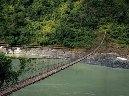
The Along Hanging Bridge is a traditional suspension structure constructed of bamboo and cane that spans the Siyom River.

Siang Riverfront scenic turquoise river flowing through lush green hills and rocky banks in Arunachal Pradesh Tour Package. River

Siang Riverfront

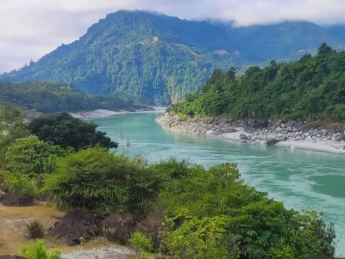
The Siang Riverfront is a natural riparian area along the banks of the Siang River, the primary tributary of the Brahmaputra, located at the eastern foothills of the Himalayas.

Aalo Town scenic hill destination in Arunachal Pradesh surrounded by lush green mountains and serene landscapes Arunachal Pradesh Package. Hill Station

Aalo Town

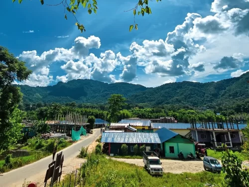
Aalo is a valley town and the administrative headquarters of the West Siang district, located at the junction of the Sipu and Siyom rivers.

Frequently Asked Questions About Patum Bridge

Patum Bridge is located near Aalo in West Siang district of Arunachal Pradesh across the Siyom River. It connects nearby villages and offers scenic river valley views.
Patum Bridge can be reached within 20 to 30 minutes by road from Aalo town by local taxi or private vehicle. The approach road passes through hilly terrain with limited public transport.
The best time to visit Patum Bridge is between October and April when the weather remains pleasant and road conditions are stable. Monsoon months may bring heavy rainfall and slippery surroundings.
Patum Bridge is popular for its suspension style structure and wide views of the Siyom River valley. Many travelers visit for photography and short stops during regional road trips.
Patum Bridge is generally safe for visitors when crossed carefully and without overcrowding. Walking calmly and following local guidance ensures a comfortable experience.
There are hotels and guesthouses available in Aalo near Patum Bridge. Most travelers stay in Aalo and visit the bridge as part of their sightseeing plan.
Patum Bridge has no commercial tourist facilities directly on site. Basic amenities such as restaurants and shops are available in Aalo town.
Most travelers spend 20 to 40 minutes at Patum Bridge enjoying the view and crossing the bridge. It is usually included as a short stop within a West Siang itinerary.
Patum Bridge may be difficult to access during peak monsoon season due to heavy rainfall and rising river levels. Checking local weather conditions before visiting is advisable.
Travelers visiting Patum Bridge should carry comfortable footwear drinking water and light rain protection during wet months. Moving cautiously while crossing ensures safety.

Loved this place ? Let’s Plan Your Arunachal Pradesh Trip

Get customized Arunachal Pradesh tour planning designed around mountain road distances, permit requirements, seasonal weather windows, and realistic travel pacing. Whether you are visiting for monasteries, high-altitude passes, river valleys, tribal cultu

⚑ Quick Response | πŸ’° Free consultation | πŸ•’ 24Γ—7 expert support

×

Plan Your Trip