Salsal La Pass: High-Altitude Mountain Pass in Changthang, Ladakh, India

Salsal la pass , Hanle
Tourists traverse Salsal La primarily as a shortcut between Tso Moriri Lake and Hanle, a route officially opened for public movement in late 2025. The pass is a destination for off-road explorers seeking extreme isolation and provides a transit point through raw Himalayan landscapes characterized by barren ridges and proximity to the high-altitude wetlands of the Chumar sector.

Quick Facts About Salsal la pass

Entry Fee Free
Timings 06:00 - 18:00
Altitude (m) 5201
Ideal Visit Duration (hrs) 1
Best Time of Day Morning
Crowd Level Low
Distance from Leh (km) 215
Distance from Hanle (km) 65
Walking Difficulty Moderate
Parking Available Yes
Last Mile Access Road
Suitable for Kids No
Suitable for Seniors No
Wheelchair Friendly No

Why Visit Salsal La Pass in Ladakh

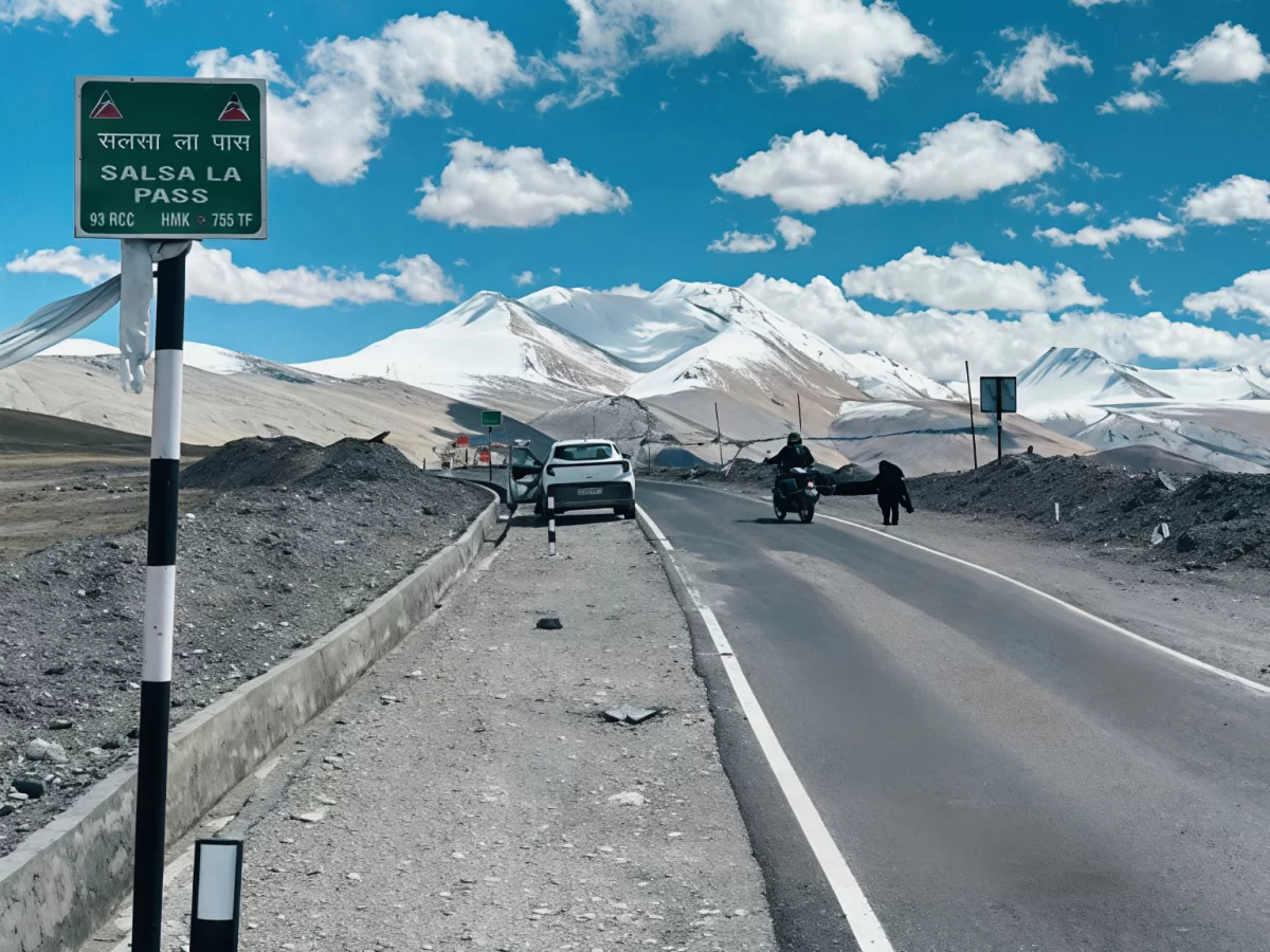
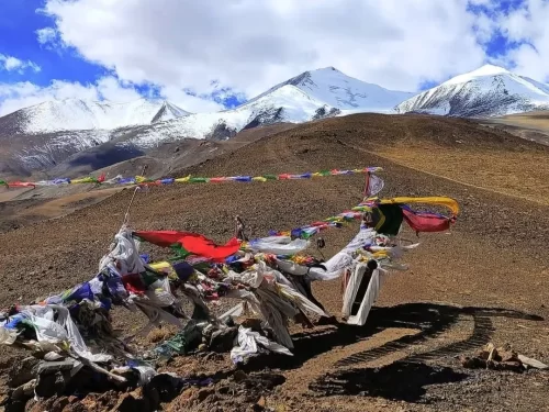
Salsal La is an extremely remote high-altitude pass situated at approximately 17,200 feet in the southeastern corner of Ladakh. Travelers venture to this isolated crossing to explore the deep interior of the Changthang plateau, as it serves as a vital but rarely used link between the nomadic lands of Hanle and the highly sensitive Chumur sector near the Indo-China border.

The on-ground atmosphere is defined by its vast, rolling plains and a profound sense of emptiness that is unique even by Ladakhi standards. The environment is a stark, high-altitude desert where the horizon feels endless, characterized by golden-brown earth and the occasional sighting of the nomadic Rebo tents, offering an experience of total immersion in one of the most secluded frontier landscapes on the planet.

What makes Salsal La distinct is its status as a gateway to the Chumur region, an area largely closed to general tourism and known for its ancient monasteries and strategic importance. It offers a rare vantage point for observing high-altitude wildlife such as the Tibetan Gazelle and Kiang in their most undisturbed habitat, making it a premier destination for off-grid explorers seeking to witness the raw, unpolished boundary where the Himalayas meet the Tibetan plateau.

Historical and Geographic Significance of Salsal La Pass

Salsal La is an ultra-high-altitude mountain pass situated at an elevation of approximately 5,200 meters (17,060 feet) in the remote Changthang region of eastern Ladakh. It serves as a vital geographic link within the high-plateau desert, connecting the Chushul sector to the Hanle valley and the legendary plains of the Rezang La region.

Geographically, the pass is characterized by its stark, wind-swept terrain and proximity to the Line of Actual Control (LAC). It represents a critical segment of the border road infrastructure, providing a tactical transit route through the mountains that flank the Spanggur Gap. The area is a high-altitude cold desert, featuring minimal vegetation and serving as a natural corridor for rare Trans-Himalayan fauna such as the Tibetan Gazelle and the Kiang.

Historically, Salsal La gained significant prominence during the 1962 Sino-Indian War, as it lies in the immediate vicinity of the historic battlegrounds of Rezang La and Gurung Hill. For centuries prior, it was a traditional route for Changpa nomads moving their pashmina herds between seasonal grazing grounds. Today, the pass is of immense strategic importance and is maintained by the Border Roads Organization (BRO). Due to its sensitive location and extreme altitude, access is strictly regulated by the Indian Army, and specific Inner Line Permits are mandatory for all visitors.

Best Time to Visit Salsal La Pass

Salsal La, a newly opened high-altitude connector standing at approximately 17,063 feet, provides a strategic and scenic shortcut between Tso Moriri and Hanle. As one of Ladakh's most remote and raw motorable passes, it is strictly a seasonal route that is only accessible during the warmest months when the Border Roads Organization (BRO) maintains the gravel tracks across the extreme Changthang plateau.

  • Ideal months: July to September is the most reliable window, with August and September offering the highest degree of road stability and the best chances of navigating the sandy, unpaved sections without encountering residual snow blocks.
  • Weather conditions: Summer at the summit is defined by "wind walls" and violent gusts that can destabilize vehicles; while midday temperatures may reach 10°C, the constant high-velocity wind and thin air make the effective temperature feel significantly colder, often plummeting below freezing the moment the sun is obscured.
  • Periods to avoid: Avoid travel from October to June as the pass is typically buried under heavy snow and remains officially closed to civilian traffic due to sub-arctic temperatures reaching -35°C; additionally, travelers should avoid crossing during late afternoon hours even in summer, as sudden dust storms and visibility-dropping winds are common after 2:00 PM.

How to Reach Salsal La Pass

Salsal La (or Salsa La) is one of Ladakh’s most significant new high-altitude motorable passes, officially cleared for tourist movement as of late 2025. Situated at an elevation of approximately 5,030m (16,500 ft), it serves as a game-changing shortcut in the Changthang region, directly connecting Tso Moriri Lake with the Hanle Valley and saving nearly 4-5 hours of travel time compared to the traditional route via Nyoma.

  • Nearest Airport: Kushok Bakula Rimpochee Airport (IXL) in Leh is the closest air link, located roughly 220 km away. Given that Salsal La is a newly opened and extremely high-altitude route, travelers must have completed extensive acclimatization (at least 4-5 days) in Leh and mid-altitude stops like Chumathang before attempting this pass.
  • Nearest Railway Station: Jammu Tawi is the nearest major railhead, approximately 840 km away. Access is exclusively via rugged road expeditions starting from Leh or coming from the Manali-Leh highway via Tso Kar.
  • Road Access and Routes: The pass creates a direct link between Karzok (Tso Moriri) and Hanle. From the Tso Moriri side, the track heads east toward the Chumur border area before crossing Salsal La to descend into the Hanle basin. This route is exceptionally remote and lacks the established infrastructure of the main highways.
  • Last-Mile Connectivity: This is a pure expedition-grade route. High-clearance 4x4 SUVs or adventure motorcycles with off-road tires are mandatory. The "road" consists of gravel, deep sandy patches, and narrow climbs with no safety barriers. Standard vehicles and novice drivers should strictly avoid this pass.
  • Permits and Border Security: As Salsal La transits through highly sensitive territory near the Indo-China border, a valid Inner Line Permit (ILP) specifically mentioning the "Hanle-Chumur-Tso Moriri" circuit is required. Permits are strictly verified at military check-posts, and travelers should carry multiple physical copies.
  • Realistic Travel Conditions: The pass is typically accessible only from July to September. It is known for violent wind gusts that can destabilize vehicles and motorcycles. There is zero mobile connectivity, no electricity, and no emergency support on this stretch. Travelers must carry extra fuel, a full puncture kit, and emergency oxygen, as the nearest help is several hours away in Hanle or Karzok.

What to Expect When You Visit Salsal La Pass

  • Expect a high altitude transit point rather than a sightseeing stop, with no marked viewpoints, signage, or facilities
  • The environment is extremely exposed, with strong winds, thin air, and sudden temperature changes even during summer months
  • There are no shops, restrooms, shelters, or food options anywhere near the pass
  • Mobile network connectivity is absent, and emergency assistance is not immediately available
  • Most travelers cross the pass without stopping due to altitude and weather exposure
  • The road surface can be rough and uneven, requiring slow driving and experienced handling
  • Altitude symptoms such as breathlessness or headache are possible, especially if acclimatization is inadequate
  • The experience is defined by remoteness and scale of landscape rather than visual landmarks

Essential Visitor Information for Salsal La Pass

  • Crowd and Weather: Salsal La is one of the most remote and least-visited passes in the Changthang region, sitting at an altitude of approximately 5,200 meters; expect total solitude and extreme weather characterized by high-velocity winds and sub-zero temperatures even in the peak of summer.
  • Peak and Quiet Visiting Hours: Best crossed between 10:00 AM and 1:00 PM to maximize sunlight and visibility; avoid traversing after 3:00 PM as the lack of any nearby settlements makes late-day travel or vehicle issues highly risky.
  • Dress Code: Full winter technical gear is required; wear a windproof down jacket, thermal base layers, and insulated gloves. Use a buff or face mask to protect against the dry, abrasive winds that cause instant windburn.
  • Safety and Altitude Cautions: At this elevation, the oxygen level is significantly lower than at sea level; limit your stay at the summit to 10 minutes and monitor for symptoms of Acute Mountain Sickness (AMS). Ensure you are traveling in a 4x4 vehicle with a high ground clearance due to the sandy and rocky terrain.
  • Logistics and Permits: This pass is located deep within a sensitive border zone near the Line of Actual Control (LAC); a specific Inner Line Permit (ILP) and military clearance are mandatory. There is zero mobile connectivity, and the nearest help is several hours away in Hanle or Chushul.
  • Practical Notes: Ensure your vehicle is carrying extra fuel and a full-size spare tire; the route involves navigating through unpaved tracks where the road often disappears into the high-altitude desert plains.

Photography Strategy and Viewpoints for Salsal La Pass

Salsal La is a high-altitude pass located at approximately 5,200 meters (17,060 feet) in the remote Changthang region. It serves as a vital gateway between the Chushul Valley and the Hanle Basin. Photography here is characterized by vast, desolate plateau landscapes and the rare opportunity to capture the stark beauty of the borderlands near the Line of Actual Control (LAC).

  • High-Altitude Desert Panoramas: The summit of Salsal La offers an expansive 360-degree view of the rolling, barren hills of the Rupshu Plateau. Use a wide-angle lens (16-35mm) to emphasize the massive scale of the earth against the deep blue, high-altitude sky, which often features dramatic, fast-moving cloud formations.
  • The Chushul Valley Vista: Looking back toward the north, you can capture the vastness of the Chushul Valley. This angle is particularly striking during the "Golden Hour" (late afternoon), when the low sun highlights the intricate textures of the alluvial fans and the winding tracks that represent the only human presence in the area.
  • Optimal Lighting and Shadow Definition: Due to the lack of vegetation, the landscape relies on shadows for depth. The best window for photography is 3:30 PM to 5:00 PM. During this time, the lateral light creates sharp definition along the ridgelines and emphasizes the various mineral shades of the sedimentary rock.
  • Technical Gear Protection: Salsal La is a high-wind corridor. The wind carries fine, abrasive sand that can be detrimental to camera gear. It is critical to use a weather-sealed camera body and avoid any lens changes at the summit. If using a tripod, ensure it is weighted or low-profile to combat the constant gusts.
  • Strict Border Zone Restrictions: Because Salsal La is in a highly sensitive military zone near the LAC, photographers must exercise extreme caution. Landscape photography is permitted, but it is strictly forbidden to photograph any military infrastructure, bunkers, or convoys. Drones are prohibited in this entire sector without high-level military clearance.
  • Atmospheric Clarity and UV Management: At 17,000 feet, the atmosphere is thin and the UV radiation is intense. A high-quality circular polarizer is essential to cut through the high-altitude haze and to prevent the sky from appearing over-bright or washed out in your compositions.

Near By Attraction

Thit Zarbo La Pass (Thang La) Ladakh Himalayas prayer flags fluttering amid brown rocky terrain with snow-capped peaks under blue sky with clouds, iconic high-altitude adventure trek tour package.  Mountain Pass

Thit Zarbo La Pass

Thit Zarbo La is a high-altitude motorable pass situated at an elevation of approximately 5,213 meters (17,103 feet) in the southeastern Changthang region of Ladakh.

Umling La Ladakh BRO Himank signboard world's highest motorable pass 19300 ft prayer flags mountains, Changthang plateau adventure peak clouds, perfect Ladakh biking offroad expedition package. Mountain Pass

Umling La Pass

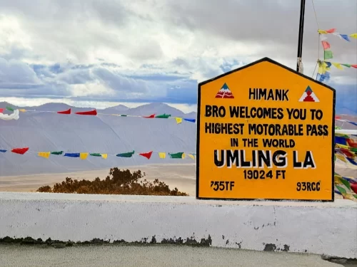
Umling La is a high-altitude mountain pass in the Eastern Ladakh region, situated at an elevation of 5,798 meters (19,024 feet) according to Guinness World Records.

Large red I Love Hanele signpost yellow road sign Way to Umlingla 63 km via Photila Top green directional poles barren Ladakh rocky terrain partly cloudy blue sky, perfect high-altitude route Ladakh adventure package. Mountain Pass

Photi La

Photi La is a high-altitude mountain pass in the Leh district that serves as a remote gateway to the Hanle region of eastern Ladakh.

Frequently Asked Questions About Salsal la pass

Salsal La pass is located in the remote Changthang Plateau of southeastern Ladakh near the border areas beyond Nyoma and Hanle. It lies in a sparsely populated high altitude region far from Leh city.
Travelers reach Salsal La pass by driving roughly 250 to 300 kilometers from Leh via the Nyoma and Hanle route depending on the exact approach taken in Ladakh. The journey involves long stretches through isolated terrain.
Visitors need an Inner Line Permit issued in Leh to access the restricted Changthang region surrounding Salsal La pass because it lies close to sensitive border zones.
Salsal La pass stands at an elevation of approximately 17,200 feet in the Changthang region where oxygen levels are considerably lower than in Leh city.
Road conditions at Salsal La pass mainly consist of unpaved gravel tracks sandy stretches and steep inclines that require careful driving through rugged mountain landscapes.
The best time to visit Salsal La pass is between June and September when high altitude roads in this part of Ladakh are generally open and less affected by heavy snowfall.
There are no food stalls fuel stations or accommodation facilities at Salsal La pass so travelers must carry sufficient supplies from Hanle Nyoma or Leh.
Salsal La pass is not suitable for regular small cars and is best attempted in high clearance 4x4 vehicles or well equipped adventure motorcycles due to rough terrain.
Tourists usually cannot visit Salsal La pass during winter because snowfall and extreme cold conditions make the route inaccessible in the Changthang region of Ladakh.
Salsal La pass serves as an alternate high altitude route connecting remote areas like Hanle and Tso Moriri which can help reduce travel distance for experienced travelers exploring eastern Ladakh.

Loved this place ? Let’s Plan Your Ladakh Trip

Get customized Ladakh tour planning designed around altitude comfort, acclimatization time, weather windows, and real Himalayan road conditions. Whether you are visiting for high mountain passes, monasteries, lakes, or remote valley experiences, our exper

⚑ Quick Response | πŸ’° Free consultation | πŸ•’ 24Γ—7 expert support

×

Plan Your Trip