Photi La Pass Travel Guide: Ladakh High Altitude Route Planning

Photi La , Hanle
Travelers visit this pass to experience one of the highest motorable roads in the world and to witness the stark, expansive landscapes of the Changthang plateau. It is primarily accessed by those heading toward the Indian Astronomical Observatory or seeking off-the-beaten-path high-altitude driving routes near the Indo-China border.

Quick Facts About Photi La

Entry Fee Free
Timings 06:00 - 18:00
Altitude (m) 5524
Ideal Visit Duration (hrs) 0.25
Best Time of Day Morning
Crowd Level Low
Distance from Hanle (km) 30
Walking Difficulty High
Parking Available Yes
Last Mile Access Road
Suitable for Kids No
Suitable for Seniors No
Wheelchair Friendly No

Why Visit Photi La Pass in Hanle, Ladakh

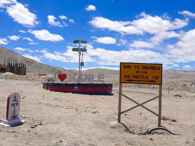
Photi La Pass is a strategic high-altitude gateway utilized by travelers to reach the remote settlements of Photi Le and Photile, serving as a vital link on the rugged overland route toward Chismule and the world's highest motorable pass, Umling La. It attracts off-grid explorers looking to traverse the expansive Hanle valley and push deeper into the frontier landscapes of the Changthang region.

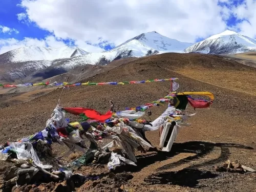
The atmosphere at the 18,124-foot summit is defined by an intense, desolate silence and the physical challenge of extreme high-altitude conditions. On the ground, the experience is characterized by winding dirt tracks and steep gradients that offer a raw, unshielded perspective of the vast, rolling plains and the stark crystalline peaks that border the Indo-China frontier.

What makes Photi La distinct is its role as a precursor to the Umling La ascent, providing a transitional landscape where the sparse vegetation of Hanle gives way to high-desert scree slopes. It offers travelers a rare opportunity to experience one of the most secluded sections of the trans-Himalayan borderlands, far removed from the primary tourist circuits of central Ladakh.

Historical and Geographic Significance of Photi La Pass

Photi La Pass is a high-altitude mountain pass situated at an elevation of approximately 5,520 meters (18,124 feet) in the Changthang region of Ladakh, India. It serves as a critical vantage point and transit route between Hanle and the Photile Village, offering a direct link to one of the most remote inhabited regions in the Himalayas.

The pass is primarily significant for its proximity to the Indian Astronomical Observatory in Hanle, providing the high-altitude atmospheric clarity required for deep-space observation. Historically, this route has been utilized by nomadic Changpa herders for moving livestock across the high-plateau grasslands, maintaining a traditional lifestyle that predates modern infrastructure in the region.

Due to its extreme elevation and proximity to the Line of Actual Control (LAC), Photi La carries strategic military importance and requires specific inner-line permits for civilian access. The terrain is characterized by its stark, desert-like environment and remains snow-bound for a significant portion of the year, limiting traversability to the summer months.

Best Time to Visit Photi La Pass

Photi La Pass is a high-altitude destination in Eastern Ladakh that is accessible only during the brief Himalayan summer when the snow on the hairpin bends of the Hanle-Umling La axis is cleared. Due to its extreme elevation of over 18,100 feet, the pass remains closed to civilian traffic for the majority of the year, making timing critical for a successful summit.

  • Ideal months: June to September is the primary window for visiting, with the highest reliability of road access occurring in late June and early September.
  • Weather conditions: During the peak season, daytime temperatures at the summit typically hover between 5°C and 12°C under clear, harsh sunlight, though wind chill can make it feel much colder; oxygen levels are significantly lower than in Leh, often leading to rapid onset of altitude-related fatigue.
  • Periods to avoid: Avoid attempting the pass from November to May when heavy snow accumulation and sub-zero temperatures (dropping below -30°C) make the road impassable and extremely dangerous; the monsoon weeks of late July and August should be approached with caution as sudden cloudbursts in the Hanle region can cause flash floods and mudslides on the steep ascent.

How to Reach Photi La Pass

Reaching Photi La Pass, a high-altitude gateway in the Changthang region, requires careful planning due to its extreme elevation (~5,520m) and remote location near the Indo-China border. Most travelers use the village of Hanle as their base before attempting the ascent.

  • Nearest Airport: Kushok Bakula Rimpochee Airport (IXL) in Leh is the closest air link, located approximately 275 km from Hanle. From the airport, travelers must spend at least 48 hours in Leh for mandatory acclimatization before proceeding toward the higher altitudes of Photi La.
  • Nearest Railway Station: Jammu Tawi is the primary railhead, roughly 800 km away. Due to the extreme distance, it is more practical to fly into Leh or drive from Manali/Srinagar.
  • Road Access from Leh: The most common route is Leh – Karu – Upshi – Chumathang – Nyoma – Hanle. This journey takes 9–10 hours via the Leh-Loma highway. The road is mostly paved up to Hanle, but conditions can vary near river crossings and high-altitude sections.
  • Last-Mile Connectivity: From Hanle, Photi La Pass is about 30 km away. The route involves a steep climb on a mix of broken tarmac, loose gravel, and dirt tracks. High-clearance 4x4 vehicles or heavy-duty adventure motorcycles are strictly recommended for this section.
  • Travel Permits: As of 2026, domestic and international tourists require a valid Inner Line Permit (ILP) or Protected Area Permit (PAP) issued from Leh to visit the Hanle and Photi La region. Carry multiple physical copies for various check-posts at Loma and Nyoma.
  • Realistic Conditions: Oxygen levels are significantly lower here than at Khardung La. The pass is often extremely windy and cold even in mid-summer. Due to the risk of Acute Mountain Sickness (AMS), stops at the summit should be limited to 5–10 minutes. The route is typically accessible only from June to

What to Expect When You Visit Photi La Pass

  • Environment and Surroundings: At an elevation of 5,508 meters (18,071 feet), the pass features a high-altitude desert landscape with extreme exposure to wind and sub-zero temperatures. The terrain is characterized by loose scree, barren rocky slopes, and a lack of vegetation, offering panoramic views of the Zanskar Range and the Indus Valley.
  • Facilities and Amenities: There is no infrastructure at the summit. You will find no shops, permanent shelters, medical facilities, or public restrooms. Travelers must be entirely self-sufficient, carrying adequate fuel, water, and emergency supplies, as the nearest basic services are located in Hanle or Nyoma.
  • Accessibility and Movement: Access is primarily via a steep, unpaved gravel track that requires a high-clearance 4x4 vehicle. The road is prone to closures due to seasonal snow or landslides and is physically demanding for drivers. Due to the proximity to the Line of Actual Control (LAC), an Inner Line Permit (ILP) and specific military clearance are mandatory for all visitors.
  • Visitor Behavior and Conditions: Oxygen levels are significantly lower than at sea level, posing a high risk of Acute Mountain Sickness (AMS); most visitors limit their stay at the summit to 10–15 minutes. Physical exertion should be kept to a minimum, and overnight camping at the pass is prohibited due to the extreme physiological strain and sensitive border security.

Essential Visitor Information for Photil La Pass

  • Crowd and Weather: Expect extreme isolation with very few tourists; the weather is characterized by intense high-altitude winds and sub-zero temperatures even in summer.
  • Peak and Quiet Visiting Hours: Best visited between 10:00 AM and 2:00 PM for maximum sunlight and visibility; avoid crossing after 4:00 PM as temperatures plummet and wind speeds increase significantly.
  • Dress Code: Heavy winter layering is mandatory year-round, including a windproof down jacket, thermal inner-wear, woolen cap (covering ears), and insulated gloves.
  • Safety and Altitude Cautions: Located at approximately 5,524 meters (18,124 feet), the oxygen level is nearly 50% lower than at sea level; limit your stay at the summit to 10 minutes to prevent Acute Mountain Sickness (AMS).
  • Practical Road Notes: Accessible only via high-ground-clearance 4x4 vehicles or adventure motorcycles due to loose gravel, broken tarmac, and steep gradients on the route from Hanle.
  • Health Requirement: At least 48–72 hours of prior acclimatization in Hanle or Leh is essential before attempting this pass.

Capturing the High Altitude Landscapes of Photi La Pass

At an elevation of approximately 5,508 meters (18,071 feet), Photi La Pass offers a stark, high-altitude desert aesthetic characterized by sharp ridgelines and vast visibility toward the Hanle Valley. To document this remote Himalayan pass effectively, consider the following technical and environmental factors:

  • Primary Vantage Points: The most comprehensive views are found 50 meters before the prayer-flag-adorned summit, looking back toward the winding hairpin curves (Z-loops) that provide a sense of scale against the barren mountainside. From the crest, point your lens southeast to capture the distant horizon of the Tibetan plateau.
  • Optimal Lighting and Timing: The "Golden Hour" here occurs significantly earlier than at sea level due to the surrounding peaks; aim for 3:30 PM to 4:30 PM to catch long shadows across the valley floor. Midday sun is exceptionally harsh and creates high-contrast glares on the grey scree slopes, often blowing out highlights in digital sensors.
  • Atmospheric Conditions: The air is exceptionally thin and clear, reducing haze but increasing UV exposure. A circular polarizer is essential to manage the deep blue "near-space" sky tones and to prevent the landscape from appearing washed out.
  • Access and Crowd Factors: Photi La is one of the least visited high passes in Ladakh. You will likely have the summit to yourself, allowing for tripod setups without interference. However, high wind speeds are constant; use a weighted tripod to prevent camera shake during long exposures.
  • Permits and Restrictions: While photography of the landscape is permitted, the pass is in a sensitive border zone near the Line of Actual Control (LAC). Do not photograph any military convoys, bunkers, or personnel encountered along the ascent from Hanle.

Near By Attraction

Thit Zarbo La Pass (Thang La) Ladakh Himalayas prayer flags fluttering amid brown rocky terrain with snow-capped peaks under blue sky with clouds, iconic high-altitude adventure trek tour package.  Mountain Pass

Thit Zarbo La Pass

Thit Zarbo La is a high-altitude motorable pass situated at an elevation of approximately 5,213 meters (17,103 feet) in the southeastern Changthang region of Ladakh.

Umling La Ladakh BRO Himank signboard world's highest motorable pass 19300 ft prayer flags mountains, Changthang plateau adventure peak clouds, perfect Ladakh biking offroad expedition package. Mountain Pass

Umling La Pass

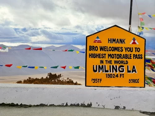
Umling La is a high-altitude mountain pass in the Eastern Ladakh region, situated at an elevation of 5,798 meters (19,024 feet) according to Guinness World Records.

Nurbula Top (Nurbula Pass) Ladakh signboard Project Himank welcomes 17328 ft Nubra 1753 ft hazy mountains barren plateau gravel road, perfect high-altitude adventure Ladakh tour package. Mountain Pass

Nurbu La

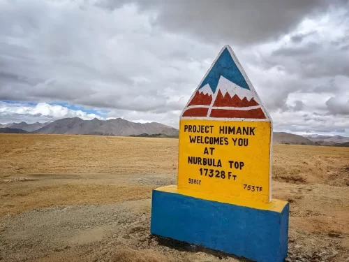
Nurbu La is a high-altitude mountain pass in Ladakh that connects Hanle to Umling La, offering scenic high-mountain views.

Frequently Asked Questions About Photi La

Photi La is a high mountain pass located in the western part of Ladakh between Lamayuru and the Kargil region. It stands at an elevation of over 5500 meters and offers wide views of the surrounding Himalayan ranges.
Photi La can be reached by road from Leh city in Ladakh via the Leh Kargil highway and a diversion near Lamayuru. The drive involves steep mountain roads and usually requires an experienced driver.
No special Inner Line Permit is typically required for Photi La in Ladakh if traveling along the regular highway route. Travelers should still confirm current regulations in Leh city before departure.
The best time to visit Photi La in Ladakh is from June to September when the roads remain open and weather conditions are relatively stable. Early season visits depend on snow clearance at higher altitudes.
Most travelers spend 20 to 40 minutes at Photi La in Ladakh for photography and short breaks. It is usually explored as part of a larger journey between Leh city and Kargil.
Photi La in Ladakh is suitable for families if they are comfortable with high altitude travel and long road journeys. Short stops and gradual acclimatization in Leh city are important before crossing high passes.
Road conditions toward Photi La in Ladakh include narrow mountain stretches with sharp turns and occasional rough patches. Driving cautiously from Leh city is essential due to altitude and terrain.
There are no food stalls or fuel stations directly at Photi La in Ladakh. Travelers should refuel and carry essentials from Leh city or nearby towns before heading toward the pass.
Photi La is located at very high altitude in Ladakh where oxygen levels are significantly lower. Visitors may feel lightheaded or breathless if they ascend too quickly without acclimatizing in Leh city.
Photi La in Ladakh is often combined with travel toward Lamayuru, Kargil, or other western Ladakh routes. It fits naturally into longer road circuits starting from Leh city.
Mobile network coverage at Photi La in Ladakh is unreliable or absent due to its remote location. Travelers should not depend on connectivity and plan communication in advance from Leh city.

Loved this place ? Let’s Plan Your Ladakh Trip

Get customized Ladakh tour planning designed around altitude comfort, acclimatization time, weather windows, and real Himalayan road conditions. Whether you are visiting for high mountain passes, monasteries, lakes, or remote valley experiences, our exper

⚑ Quick Response | πŸ’° Free consultation | πŸ•’ 24Γ—7 expert support

×

Plan Your Trip