Mig La Pass: The World's Highest Motorable Road in Eastern Ladakh, India

Mig La Pass , Hanle
Tourists visit Mig La to experience the current highest motorable road in the world, a title it officially claimed in October 2025 by surpassing Umling La. The pass is a major landmark for extreme adventure travelers and connects the Hanle region to the border settlement of Fukche, offering views of the sensitive Indo-China frontier and high-altitude wildlife in an environment where oxygen levels are approximately 50 percent lower than at sea level.

Quick Facts About Mig La Pass

Entry Fee Free
Timings 06:00 - 18:00
Altitude (m) 5913
Ideal Visit Duration (hrs) 1
Best Time of Day Morning
Crowd Level Low
Distance from Hanle (km) 100
Walking Difficulty Hard
Parking Available Yes
Last Mile Access Road
Suitable for Kids No
Suitable for Seniors No
Wheelchair Friendly No

Why Visit Mig La Pass in Ladakh

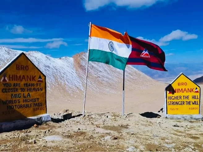
Mig La Pass has emerged as the definitive pinnacle for high-altitude explorers, officially claiming the title of the world’s highest motorable road at an extraordinary elevation of 19,400 feet. Travelers journey to this remote location in the Leh district to traverse the Likaru-Mig La-Fukche (LMLF) road, a groundbreaking feat of engineering by the Border Roads Organisation that surpasses the previous record held by Umling La.

The on-ground atmosphere is one of extreme, thin-air isolation, situated deep within the Changthang Plateau near the Line of Actual Control. At this altitude, oxygen levels are nearly 50% lower than at sea level, creating a visceral environment where the stark, high-arctic desert landscape meets a horizon of absolute silence and profound geological scale, offering a level of frontier solitude that is unmatched elsewhere on the planet.

What makes Mig La distinct is its strategic role as the new "top of the world," providing a critical link between the Hanle sector and the Fukche Advanced Landing Ground. It offers travelers the unique opportunity to navigate a route that sits higher than both the North and South Base Camps of Mount Everest, providing unparalleled views of the sensitive borderlands and a sense of standing at the highest accessible point on Earth’s road network.

Historical and Geographic Significance of Mig La Pass

Mig La is currently recognized as the location of the world highest motorable road, situated at a staggering elevation of 19,400 feet (5,913 meters) in the Leh district of Ladakh. Positioned on the Changthang Plateau, it surpassed the previous record held by Umling La in 2025, representing a new pinnacle in high-altitude infrastructure and engineering within the Himalayas.

Geographically, the pass is the central feature of the 64-kilometer-long Likaru–Mig La–Fukche (LMLF) road. This strategic alignment connects Likaru village in the Hanle sector to the Fukche Advanced Landing Ground, located near the Line of Actual Control (LAC). The environment is characterized by extreme cold desert conditions, where oxygen levels are approximately 50 percent lower than at sea level and temperatures remain well below freezing for most of the year.

The pass holds immense strategic importance as it establishes a third axis for military mobility in eastern Ladakh, enhancing the logistical capabilities of the Indian Armed Forces. Historically, the project was executed by the Border Roads Organization (BRO) under Project Himank, with construction overcoming significant challenges such as loose soil and permafrost. Beyond its military utility, Mig La is a transformative development for the remote border communities of Hanle and Fukche, providing unprecedented year-round connectivity and a new destination for extreme-altitude tourism.

Best Time to Visit Mig La Pass

Mig La, standing at a staggering 19,400 feet, is officially the world's highest motorable pass, surpassing Umling La after its completion in late 2025. Located on the strategic Likaru-Mig La-Fukche axis in Eastern Ladakh, this ultra-high-altitude destination exists in a perpetual sub-arctic state where the window for civilian transit is governed by the Border Roads Organization and extreme oxygen depletion.

  • Ideal months: June to September is the only viable window, with late August and early September offering the highest probability of dry, firm tracks; civilian access is officially anticipated to open for the first time in mid-2026.
  • Weather conditions: Expect arctic-level conditions even in July; daytime temperatures rarely exceed 5°C to 10°C at the summit, while oxygen levels are nearly 50% lower than at sea level, making any physical exertion dangerous and mechanical performance unpredictable.
  • Periods to avoid: Strictly avoid travel from October to May when the pass is buried under permanent snow and temperatures plummet to -40°C; additionally, avoid visiting in early June during the thaw, as melting permafrost turns the high-altitude desert approach into impassable mud bogs that trap even heavy 4x4 vehicles.

How to Reach Mig La Pass

Mig La Pass is officially recognized as the location of the world's highest motorable road, situated at a staggering elevation of 19,400 feet (5,913 meters) on the Changthang Plateau. Surpassing the previous record held by Umling La, this strategic mountain pass in the Leh district connects the Hanle sector to the Fukche Advanced Landing Ground near the Line of Actual Control.

  • Nearest Airport: Kushok Bakula Rimpochee Airport (IXL) in Leh is the primary air link, located approximately 290 km away. Given that the altitude at Mig La is higher than both Everest Base Camps, travelers must complete a rigorous 5 to 6-day progressive acclimatization schedule in Leh and Hanle before attempting this journey.
  • Nearest Railway Station: Jammu Tawi is the closest major railhead, situated roughly 860 km away. Access to this remote border region is strictly limited to road travel via specialized high-altitude expeditions.
  • Road Access and LMLF Alignment: The pass is reached via the 64-km long Likaru–Mig La–Fukche (LMLF) Road. This alignment connects Likaru village in the Hanle region to the Fukche airfield. The road was constructed under Project Himank and represents a significant engineering feat in extreme sub-zero conditions.
  • Last-Mile Connectivity: This is an ultra-high-altitude route characterized by loose soil and oxygen levels nearly 50% lower than at sea level. High-clearance 4x4 vehicles with specialized cold-start capabilities are essential. The track is extremely demanding on both engines and drivers, requiring expedition-grade preparation.
  • Permits and Security: Mig La is located in a highly sensitive military zone just 3 km from the Line of Actual Control. A valid Inner Line Permit (ILP) or Protected Area Permit (PAP) specifically mentioning the LMLF Road or the Likaru-Fukche sector is mandatory. Multiple military checkpoints are positioned along the route to verify documentation.
  • Realistic Travel Conditions: The road is generally motorable during the summer months from late June to September, though the BRO maintains it for strategic use year-round. Tourists should be prepared for intense cold and violent winds. Due to the extreme altitude, stops at the summit must be extremely brief to prevent severe Acute Mountain Sickness (AMS), and carrying medical-grade portable oxygen is non-negotiable.

What to Expect When You Visit Mig La Pass

  • Environment and Surroundings: is officially recognized as the location of the world's highest motorable road, situated at a staggering altitude of 5,913 meters (19,400 feet). The environment is a brutal, high-altitude cold desert within the Changthang Plateau, featuring oxygen levels nearly 50 percent lower than at sea level and sub-zero temperatures even during the height of summer.
  • Facilities and Amenities: There is no civilian infrastructure at the summit. You will find no shops, medical centers, restrooms, or permanent shelters. The Likaru–Mig La–Fukche (LMLF) road is a strategic military alignment; while it enhances connectivity to remote villages like Hanle and Fukche, visitors must be entirely self-sufficient with oxygen, fuel, and survival supplies.
  • Accessibility and Movement: The pass is part of a 64-kilometer road connecting Likaru to the Fukche Advanced Landing Ground, located just three kilometers from the Line of Actual Control (LAC). The terrain consists of loose soil and rugged mountainous tracks that are physically demanding for both vehicles and travelers. Due to its extreme proximity to the border, specialized military clearance and a valid Inner Line Permit (ILP) are mandatory for all civilian movement.
  • Typical Visitor Behavior and Conditions: Most travelers experience the pass as a high-point transit marker rather than a place for a prolonged stay. Due to the extreme risk of hypoxia and altitude-related illnesses, stops at the 19,400-foot summit are typically restricted to less than 10 minutes for photography. The road is primarily used for military mobility and by experienced high-altitude adventurers who have undergone significant acclimatization.

Essential Visitor Information for Mig La Pass

  • Crowd and Weather: As the new record-holder for the world’s highest motorable road (19,400 feet), Mig La experiences absolute isolation with virtually no tourist traffic; the weather is extreme, featuring sub-zero temperatures year-round and oxygen levels approximately 50% lower than at sea level.
  • Peak and Quiet Visiting Hours: Recommended transit is strictly between 11:00 AM and 1:00 PM to take advantage of peak solar radiation; avoid the pass entirely during early mornings or late afternoons when the risk of frostbite and rapid temperature drops increases significantly.
  • Dress Code: Arctic-grade technical clothing is mandatory; wear a high-fill down jacket, heavy thermal base layers, insulated waterproof gloves, and a balaclava to protect all exposed skin from brutal wind-chill and intense UV radiation.
  • Safety and Altitude Cautions: Standing higher than the base camps of Mount Everest, the risk of HAPE (High Altitude Pulmonary Edema) is extreme; limit your stay at the summit to a maximum of 5 minutes and carry medical-grade portable oxygen cylinders.
  • Logistics and Permits: This pass is part of the Likaru–Mig La–Fukche (LMLF) road located just 3 kilometers from the Line of Actual Control (LAC); specific military clearance and a valid Inner Line Permit (ILP) are strictly required for all civilians.
  • Terrain and Vehicle Requirements: The 64-kilometer alignment involves navigating loose soil and rugged high-altitude desert terrain; only high-performance 4x4 vehicles in top mechanical condition should attempt this route, as there is zero mobile connectivity or emergency infrastructure.

Capturing the High-Altitude Vistas of Mig La Pass

  • World’s Highest Motorable Summit: The primary photography spot is the official summit marker at 19,400 feet (5,913 meters). Capturing the Indian National Flag and the Border Roads Organisation (BRO) monument against the stark Himalayan horizon provides the definitive visual proof of reaching the planet's highest motorable point.
  • Panoramic Ridgeline Perspectives: For expansive landscape shots, the elevated sections of the Likaru–Mig La–Fukche (LMLF) road offer unobstructed 360-degree views of the Changthang Plateau. These vantage points allow photographers to document the dramatic contrasts between the black-topped asphalt and the surrounding barren, snow-dusted peaks.
  • Mid-Morning Light Optimization: Due to extreme ultraviolet intensity and thin air, photography is best between 9:00 AM and 11:30 AM. This window provides sufficient natural light to illuminate the Indus Valley gorges and distant Zanskar ranges without the severe overexposure or harsh shadows common during the high noon period.
  • Strategic Border Restrictions: As the pass is a sensitive military zone located just 3 kilometers from the Line of Actual Control (LAC), drone photography is strictly prohibited. Handheld landscape photography is generally permitted, but photographers must strictly avoid framing military personnel, bunkers, or sensitive communication equipment.
  • Atmospheric Clarity and Dust: High-altitude winds on the plateau often stir up glacial dust in the late afternoon, which can create a hazy effect. Early morning visits are essential for high-contrast, "crystal-clear" shots where the deep indigo sky meets the rugged mountain textures of eastern Ladakh.
  • Human-Scale Narrative Shots: To convey the sheer scale and isolation of the 64-km LMLF road, use a telephoto lens to capture vehicles or mountain bikers navigating the sharp hairpin bends. The contrast between a small vehicle and the massive, desolate mountain faces emphasizes the engineering feat achieved by Project Himank.

Near By Attraction

Thit Zarbo La Pass (Thang La) Ladakh Himalayas prayer flags fluttering amid brown rocky terrain with snow-capped peaks under blue sky with clouds, iconic high-altitude adventure trek tour package.  Mountain Pass

Thit Zarbo La Pass

Thit Zarbo La is a high-altitude motorable pass situated at an elevation of approximately 5,213 meters (17,103 feet) in the southeastern Changthang region of Ladakh.

Umling La Ladakh BRO Himank signboard world's highest motorable pass 19300 ft prayer flags mountains, Changthang plateau adventure peak clouds, perfect Ladakh biking offroad expedition package. Mountain Pass

Umling La Pass

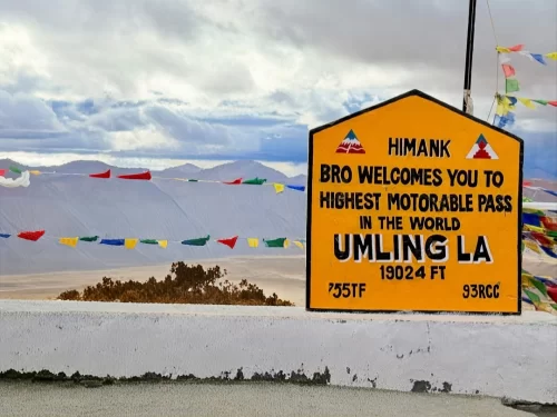
Umling La is a high-altitude mountain pass in the Eastern Ladakh region, situated at an elevation of 5,798 meters (19,024 feet) according to Guinness World Records.

Large red I Love Hanele signpost yellow road sign Way to Umlingla 63 km via Photila Top green directional poles barren Ladakh rocky terrain partly cloudy blue sky, perfect high-altitude route Ladakh adventure package. Mountain Pass

Photi La

Photi La is a high-altitude mountain pass in the Leh district that serves as a remote gateway to the Hanle region of eastern Ladakh.

Frequently Asked Questions About Mig La Pass

The best time to visit Mig La Pass is from June to September when the high altitude roads in eastern Ladakh are generally open and weather conditions are comparatively stable.
Driving from Leh to Mig La Pass takes approximately eight to ten hours depending on road and weather conditions, covering a long stretch through Nyoma and Hanle regions of Ladakh.
Travelers must obtain an Inner Line Permit to visit Mig La Pass as it lies in a sensitive border area of eastern Ladakh and access is strictly regulated.
Oxygen levels at Mig La Pass are significantly lower than at sea level due to its extreme elevation, which increases the risk of altitude sickness without proper acclimatization in Leh.
There are no permanent food stalls or restroom facilities at Mig La Pass, so visitors must carry essential supplies and use available amenities in Hanle or Nyoma before ascending.
A high clearance 4x4 SUV or a powerful adventure motorcycle is strongly recommended for reaching Mig La Pass because sections of the route are steep, rough, and partially unpaved.
Travelers should limit their stay at Mig La Pass to around fifteen to twenty minutes to reduce exposure to extreme altitude conditions.
Visitors should wear heavy thermal layers, insulated gloves, and windproof jackets when traveling to Mig La Pass because temperatures can remain near freezing even during summer months in Ladakh.
Foreign nationals are generally restricted from visiting Mig La Pass due to its proximity to the Line of Actual Control in eastern Ladakh, and permissions are tightly controlled.
Mig La Pass is usually not accessible during winter months as heavy snowfall and extreme temperatures often block the road entirely.
Mig La Pass is not recommended for senior citizens or individuals with heart or respiratory conditions because the extreme altitude poses considerable health risks.
Mig La Pass stands at an elevation of approximately 19,400 feet, making it slightly lower than Umling La, which is recognized as one of the highest motorable passes in Ladakh.

Loved this place ? Let’s Plan Your Ladakh Trip

Get customized Ladakh tour planning designed around altitude comfort, acclimatization time, weather windows, and real Himalayan road conditions. Whether you are visiting for high mountain passes, monasteries, lakes, or remote valley experiences, our exper

⚑ Quick Response | πŸ’° Free consultation | πŸ•’ 24Γ—7 expert support

×

Plan Your Trip