Teetwal Bridge: Historic LoC Crossing on the Kishanganga River, Jammu and Kashmir, India

Teetwal Bridge , Teetwal
Tourists visit Teetwal Bridge as it is one of the few designated crossing points between India and Pakistan-administered Kashmir. Spanning the turquoise waters of the Kishanganga River (known as the Neelum across the border), the bridge serves as a potent symbol of shared heritage and the emotional history of separated families. Visitors can stand on the Indian side of the bridge and observe life in the village of Chilehana just meters away on the opposite bank. The site has gained significant prominence as a border tourism destination, particularly following the reconstruction of the ancient Sharda Devi Temple nearby, which traditionally served as a base camp for pilgrims traveling to the Sharda Peeth.

Quick Facts About Teetwal Bridge

Entry Fee Free
Timings 06:00 - 18:00
Altitude (m) 900
Ideal Visit Duration (hrs) 1
Best Time of Day Morning
Crowd Level Moderate
Distance from Srinagar (km) 165
Distance from Kupwara (km) 65
Distance from Sadhna Top (km) 35
Walking Difficulty Easy
Parking Available Yes
Last Mile Access Road
Suitable for Kids Yes
Suitable for Seniors Yes
Wheelchair Friendly No

Why Visit the Teetwal Bridge in Kashmir

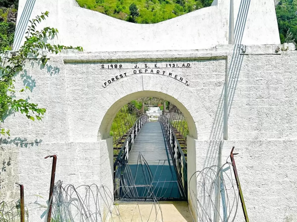
The Teetwal Bridge, also known as the White Knight Bridge, is a historic and strategic crossing point situated on the Kishanganga River, which acts as the Line of Control (LoC) between India and Pakistan-administered Kashmir. Travelers visit this unique location to stand at one of the few places where the international boundary is physically tangible, offering a profound and sobering perspective on the shared geography and divided history of the region.

The atmosphere on the ground is a rare blend of high-security vigilance and peaceful cross-border stillness. Visitors can walk right up to the edge of the river, where the two sides are separated by only a few meters of water. The sound of the rushing Kishanganga is the constant backdrop to a landscape of steep, pine-covered mountains and the quiet, resilient village of Teetwal, where the presence of the Indian Army and the proximity of the "other side" create a visceral sense of being at the very edge of the nation.

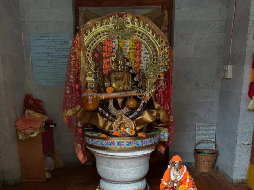
What makes the Teetwal Bridge distinct is its role as a "peace bridge" and a site of deep emotional significance for families divided by the border. It is home to the recently reconstructed Sharda Yatra Temple and a Gurudwara, marking it as a vital spiritual gateway to the ancient Sharda Peeth located just across the river. Standing on the bridge offers an unparalleled vantage point to witness the daily life of border communities and serves as a powerful reminder of the cultural and spiritual threads that continue to connect the people of the Himalayas across political lines.

Historical and Geographic Significance of Teetwal Bridge

Teetwal Bridge is a significant cross-border structure situated at an elevation of approximately 1,050 meters (3,445 feet) in the Kupwara district of Jammu and Kashmir. Spanning the Kishanganga River, it connects the village of Teetwal on the Indian side with Chilhana in Pakistan-administered Kashmir, serving as one of the few official crossing points along the Line of Control (LoC).

Geographically, the bridge is located at a narrow point of the Kishanganga River, where the water serves as the de facto international boundary. The surrounding terrain is a deep, rugged river valley flanked by steep, forested ridges of the Shamsabari range. This specific location is geographically vital as it provides the only viable low-altitude transit point for the inhabitants of the remote Karnah sector, who are otherwise hemmed in by high mountain passes that become impassable during the winter months.

Historically, Teetwal was a thriving trade hub on the ancient route to Gilgit and Skardu before the partition of the subcontinent. Following the conflict of 1947-48, the original bridge was destroyed and the area became a heavily militarized zone. In 2005, the bridge gained renewed humanitarian importance when it was designated as one of the five "Meeting Points" (TCFs) to facilitate the exchange of relief material and allow divided families to meet following the devastating Kashmir earthquake. Today, the white line marked in the center of the bridge remains a powerful symbol of the regional geopolitical reality, while the nearby reconstructed Sharda Peeth base temple and a newly built Gurudwara have turned the area into a significant site for religious and cultural heritage tourism.

Best Time to Visit Teetwal Bridge

Teetwal Bridge, an emotionally charged suspension bridge spanning the Kishanganga River at approximately 5,500 feet, serves as a significant landmark on the Line of Control (LoC). While the bridge itself is at a lower altitude than the surrounding passes, access to the village is entirely dependent on the status of Sadhna Top. The site has recently grown in spiritual and cultural prominence with the reconstruction of the Sharda Devi Temple nearby, making it a key destination for heritage tourism in the Karnah region.

  • Ideal months: April to October is the peak window for visiting; the months of May and June offer the most pleasant weather for exploring the riverside, while September and October provide the crispest views of the LoC and the adjacent mountains.
  • Weather conditions: Summer daytime temperatures are mild, typically ranging from 15°C to 25°C, though the valley is prone to sudden humidity and localized rain; the proximity to the river ensures a constant cool breeze, but sun protection is still necessary during the midday hours.
  • Periods to avoid: Avoid travel from December to March when the primary access route via Sadhna Pass is frequently blocked by heavy snow and avalanches, making the Karnah Valley inaccessible; additionally, the peak monsoon weeks of late July and August should be approached with caution as the mountain roads from Kupwara are highly susceptible to landslides.

How to Reach Teetwal Bridge

Teetwal Bridge is a significant border crossing point located on the Kishanganga River in the Kupwara district of Jammu and Kashmir. Situated at the Line of Control (LoC), this bridge—reconstructed as the "Bridge of Peace"—connects Teetwal in India with Chilhana in Pakistan-administered territory. It serves as a vital point for divided families to meet and stands as a symbol of peace and cross-border cultural connection.

  • Nearest Airport: Srinagar International Airport (SXR) is the closest air link, located approximately 165 km away. The journey involves a 6 to 8-hour drive crossing the high-altitude Sadhna Top (3,120m).
  • Nearest Railway Station: Baramulla Railway Station is the nearest railhead, roughly 100 km away. From Baramulla, travelers can hire private taxis or use shared transport via Kupwara and Chowkibal.
  • Road Access and Route: The route follows the path from Srinagar to Kupwara, then to Chowkibal, and finally over the Sadhna Pass to reach the Tangdhar Valley. From Tangdhar, a further 15 km drive brings you to the riverside village of Teetwal. The road is paved but involves extreme mountain driving with sharp gradients and hairpin bends.
  • Last-Mile Connectivity: The village of Teetwal is accessible by all sturdy vehicle types, including SUVs and local shared taxis (Sumos). The bridge itself is located at the edge of the village, and visitors must park their vehicles and walk a short distance to the designated viewing and meeting areas.
  • Permits and Security: As Teetwal is located directly on the Line of Control, security is exceptionally tight. Indian citizens must carry original Aadhaar cards and may need to obtain a "Border Permit" or register at the army checkpoints in Chowkibal and Tangdhar. Foreign nationals are generally restricted from this sensitive border zone and require specific Ministry of Home Affairs clearance.
  • Traveler Logistics: Visitors can stand just a few feet away from the river that marks the international boundary. Photography is strictly regulated; while the bridge and the scenic valley are popular subjects, photography of military bunkers, personnel, or specific strategic installations is prohibited.
  • Practical Amenities: Teetwal is a remote border village with limited infrastructure. Basic homestays are available for those wishing to experience the local culture. Most travelers use Tangdhar for basic meals and fuel. Mobile connectivity is extremely limited, with BSNL providing the only intermittent signal.

Essential Visitor Information for Teetwal Neelam LOC BridgeClick to open side panel for more information

  • Crowd and Weather: Teetwal is a high-sensitivity border village where the bridge serves as a "Line of Control" crossing point; the area is typically quiet but involves a significant military presence. The weather is temperate during summer (May–September), while winters are harsh with occasional snow blocking the high passes leading to the valley.
  • Peak and Quiet Visiting Hours: Visitors are generally permitted to visit the riverside and the bridge area between 10:00 AM and 4:00 PM; it is critical to leave the border zone before dusk as strict night curfews and security protocols are enforced by the military.
  • Dress Code and Conduct: Modest and respectful attire is mandatory in this conservative frontier community. Photography is strictly regulated; while photos of the surrounding scenery may be allowed, taking pictures of military personnel, bunkers, or the bridge structure itself is often prohibited and can lead to immediate questioning.
  • Safety and Border Sensitivity: As this is the actual Line of Control where the Kishanganga River separates India and Pakistan-administered territory, security is paramount; carry original government-issued photo IDs at all times. Remain on designated paths and do not attempt to cross any fences or enter the river without explicit permission from the on-ground commanders.
  • Logistics and Access: The journey from Kupwara involves crossing the challenging Sadhna Top; ensure your vehicle is in excellent condition and has enough fuel for the return trip. Mobile connectivity is extremely limited, and there are no commercial hotels—accommodation is restricted to basic government rest houses or local homestays.

What to Expect When You Visit Teetwal Bridge

  • Environment and Surroundings: Teetwal Bridge is an emotionally significant suspension bridge located on the Line of Control (LoC) along the banks of the Kishanganga River. The setting is one of profound silence and natural beauty, featuring crystal-clear turquoise waters and steep, pine-covered mountain ridges. It is a unique vantage point where travelers can stand on the riverbank and clearly see houses and local life in the villages across the border.
  • Facilities and Amenities: There is almost no commercial infrastructure at the bridge itself. You will find no hotels, restaurants, or modern restrooms. A small, recently reconstructed Sharda Devi Temple and a Sikh Gurudwara are located within walking distance, serving as the main cultural and spiritual hubs. Visitors must carry their own food and water, as the nearest basic markets are in the towns of Tangdhar or Karnah, which are a significant distance away.
  • Accessibility and Movement: Reaching Teetwal requires a 9 to 11-hour drive from Srinagar, involving a crossing of the high-altitude Sadhna Pass. The road is steep and winding, demanding experienced mountain driving. Due to its location right on the LoC, security is extremely high; all visitors must clear multiple army checkpoints, and a valid government-issued photo ID (Aadhaar or Passport) along with a specific travel permit is mandatory for non-residents.
  • Typical Visitor Behavior and Conditions: Most visitors spend 30 to 60 minutes here for quiet reflection and photography of the river and mountains. It is a site of deep emotional impact for heritage travelers and divided families. Photography is strictly monitored; while taking pictures of the scenery is generally allowed, photographing military installations, bunkers, or personnel is absolutely prohibited. Mobile network coverage is non-existent, and visitors are expected to depart before sunset.

Capturing the Divided Landscape of Teetwal Bridge

  • Kishanganga River Mid-Point: The most significant shot is taken from the Indian side of the suspension bridge, looking directly across the Kishanganga River, which serves as the Line of Control (LoC). This unique perspective allows photographers to capture the white line on the bridge floor that physically separates India and Pakistan.
  • Cross-Border Village Perspectives: From the Teetwal riverbank, use a telephoto lens to frame the village of Chilhana on the opposite side. This "frontier" photography provides a rare visual of two neighboring communities separated by a narrow glacial river, emphasizing the geopolitical and cultural proximity of the region.
  • Morning Clarity and Soft Light: The valley is deep and narrow, meaning direct sunlight reaches the bridge later in the morning. The best time for photography is between 9:00 AM and 11:00 AM, when the light is even and the turquoise water of the Kishanganga is fully illuminated without the heavy shadows cast by the steep valley walls.
  • Strict Security and Photography Bans: Photography is highly regulated at this sensitive crossing. While capturing the bridge and general landscape from designated tourist points is permitted, it is strictly prohibited to photograph military bunkers, security personnel, surveillance equipment, or specific fortification details on either side of the border.
  • The "Peace Bridge" Symbolism: Focus on the gate and the ceremonial structures at the entrance of the bridge. These shots are best captured with a wide-angle lens to include the fluttering Indian National Flag and the rugged Himalayan terrain that towers over this small, strategic passage.
  • Ground-Level Riverbank Shots: Descending to the rocky banks of the Kishanganga near the bridge allows for low-angle compositions. Using the rushing water as a foreground element leading toward the bridge structure adds a sense of motion and emphasizes the natural boundary that the river represents.

Near By Attraction

Teetwal Village Sharda Devi idol shrine during indoor lighting Kashmir, featuring golden veena garlands red drapes pedestal small Hanuman statue stone walls, perfect Kashmir tour packages. Temple

Sharda Devi Temple

The Sharda Devi Temple at Teetwal is a recently reconstructed Hindu shrine situated at an elevation of approximately 1,600 meters (5,250 feet) on the banks of the Kishanganga River in the Kupwara district.

Frequently Asked Questions About Teetwal Bridge

Teetwal Bridge is located near the Line of Control in the Kupwara district of Jammu and Kashmir, built across the Kishanganga River. It connects border areas that hold both historical and strategic importance.
Teetwal Bridge can be reached by road from Srinagar via Kupwara, and the journey typically takes 5 to 6 hours depending on road and weather conditions. The route passes through mountainous terrain and security checkpoints.
Permission may be required to visit Teetwal Bridge because it lies in a sensitive border zone. Visitors must carry valid identification and comply with local security regulations.
The best time to visit Teetwal Bridge is between May and October when weather conditions are stable and roads remain open. Clear days offer better views of the surrounding mountains and river valley.
Around 30 to 60 minutes are generally sufficient to explore Teetwal Bridge and the nearby riverbank area. The overall trip usually takes a full day due to the long travel distance.
Teetwal Bridge is suitable for families who are comfortable with extended road travel and security checks. The site itself involves minimal walking but requires adherence to border guidelines.
Teetwal Bridge can be visited during winter if road conditions permit, though snowfall in Jammu and Kashmir may affect accessibility. Checking travel updates before departure is important.
Visitors at Teetwal Bridge can see the flowing Kishanganga River, surrounding hills, and the physical border crossing structure. The atmosphere reflects both natural beauty and geopolitical significance.
Photography at Teetwal Bridge may be restricted in certain directions due to its proximity to security sensitive areas. Travelers should follow instructions given by authorities on site.
Facilities near Teetwal Bridge are limited due to its remote location. Visitors should carry water and essentials as there are few commercial establishments nearby.
Teetwal Bridge can be combined with a visit to Sharda Devi Temple Teetwal and scenic drives through the valley during the same trip. The route itself offers river and mountain views.
Travelers planning to visit Teetwal Bridge should prepare for security procedures, long travel hours, and limited infrastructure. Proper identification and early departure help ensure a smoother visit in this border region of Jammu and Kashmir.

Loved this place ? Let’s Plan Your Jammu and Kashmir Trip

Get customized Jammu and Kashmir tour planning designed around seasonal weather patterns, valley travel routes, snow conditions, and realistic hill road timing. Whether you are visiting for scenic landscapes, serene lakes, spiritual journeys, meadow stays

⚑ Quick Response | πŸ’° Free consultation | πŸ•’ 24Γ—7 expert support

×

Plan Your Trip