+91 9910402252
admin@chalbanjare.com
| Entry Fee | No entry fee |
| Timings | Accessible throughout the day during the road-open season, typically from June to October; access depends on weather and road conditions. |
| Altitude (m) | Approximately 4,890 m above sea level |
| Ideal Visit Duration | 30 minutes–1 hour |
| Best Time of Day | Morning to early afternoon for clearer weather and better visibility |
| Crowd Level | Low to moderate; busiest during the Manali–Leh travel season |
| Distance from City Centre (km) | Approximately 65 km from Jispa |
| Walking Difficulty | Easy; minimal walking required from the roadside viewpoint, though the high altitude can make physical activity more demanding |
| Parking Available | Limited roadside parking available near the lake |
| Last Mile Access | Directly accessible by road via the Manali–Leh Highway near Baralacha La Pass; no trekking required |
| Suitable for Kids | Yes, with proper supervision and altitude precautions |
| Suitable for Seniors | Suitable for healthy seniors acclimatized to high altitude conditions |
| Wheelchair Friendly | Partially; roadside viewing is possible, but uneven terrain limits full accessibility |
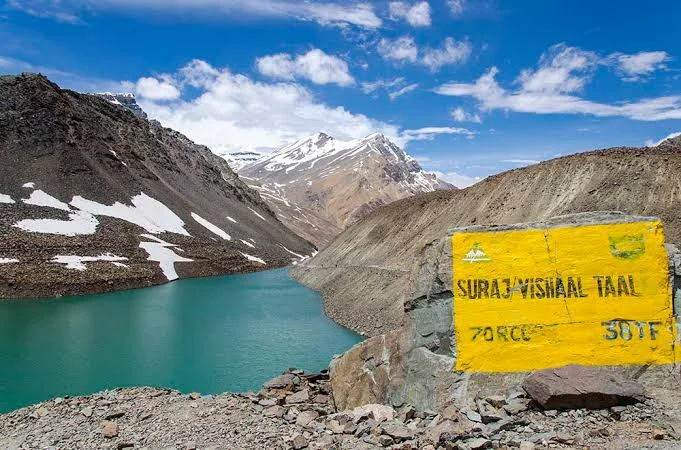
Visitors come to Suraj Tal Lake to witness one of the highest lakes in India, surrounded by rugged Himalayan terrain and dramatic high-altitude landscapes along the Manali–Leh route.
The atmosphere is remote and awe-inspiring, with crisp mountain air, sparse vegetation, and vast open views that highlight the raw beauty of the Lahaul region.
What makes Suraj Tal Lake distinct is its glacial origin, striking turquoise waters during the summer months, and its location near Baralacha La Pass, making it a memorable stop on one of the Himalayas’ most scenic road journeys.
Suraj Tal, meaning "Lake of the Sun God," is a high-altitude glacial lake located near the Baralacha La Pass in the Lahaul region of Himachal Pradesh. Fed by snowmelt and glaciers of the surrounding Himalayan mountains, the lake has long been an important natural landmark along the historic route connecting Lahaul, Ladakh, and Spiti.
For centuries, traders, travelers, and local communities traversing the trans-Himalayan passes passed through this region, making Suraj Tal a notable geographical feature on ancient mountain trade routes. The lake is also recognized as the source of the Bhaga River, which later joins the Chandra River to form the Chandrabhaga (Chenab) River.
Today, Suraj Tal is valued for its dramatic alpine setting and its significance within the natural and geographical heritage of the western Himalayas.
Suraj Tal Lake is best visited during the summer and early autumn months when the Manali–Leh Highway is open, weather conditions are relatively stable, and the high-altitude lake is accessible without snow-related road closures.
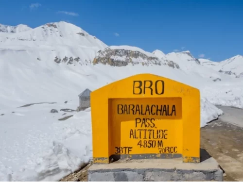 Mountain Pass
Baralacha La is a high-altitude mountain pass in the Zanskar Range, situated at an elevation of approximately 4,890 meters (16,043 feet) along the Leh-Manali Highway.
Get customized Himachal Pradesh tour planning designed around season, road conditions, hill travel pacing, and comfort preferences. Whether you are visiting for snow experiences, mountain landscapes, temple towns, adventure activities, or relaxed valley s
⚡ Quick Response | 💰 Free consultation | 🕒 24×7 expert support

