Baralacha La Pass: High-Altitude Mountain Pass in Lahaul, Himachal Pradesh, India

Baralacha La , Jispa
Tourists cross Baralacha La because it serves as a critical geographical junction connecting the Lahaul Valley in Himachal Pradesh with the Ladakh region. The pass is a major landmark for adventure travelers and motorcyclists, featuring the nearby Suraj Tal (the source of the Bhaga River) and offering a landscape where the Zanskar, Pir Panjal, and Great Himalayan ranges converge.

Quick Facts About Baralacha La

Entry Fee Free
Timings 00:00 - 23:59
Altitude (m) 4890
Ideal Visit Duration (hrs) 1
Best Time of Day Morning
Crowd Level High
Distance from Manali (km) 190
Distance from Keylong (km) 73
Walking Difficulty Moderate
Parking Available Yes
Last Mile Access Road
Suitable for Kids Yes
Suitable for Seniors Yes
Wheelchair Friendly No

Why Visit Baralacha La Pass on the Manali-Leh Highway

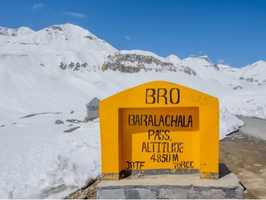
Baralacha La is a high-altitude plateau pass situated at 15,912 feet in the Zanskar Range, acting as the geographical gateway between the Lahaul Valley and Ladakh. It is a primary destination for travelers who wish to witness the birth of major Himalayan rivers, as it serves as the triple watershed where the Bhaga, Chandra, and Yunam rivers originate from the surrounding glacial melts.

The atmosphere on the pass is dominated by the massive, year-round snowdrifts and the emerald-green waters of Suraj Tal, the "Lake of the Sun God," which sits just below the summit. The environment is frequently volatile, with rapid weather shifts and high-velocity winds that sweep across the vast, open saddle, emphasizing the raw and unpredictable nature of the trans-Himalayan high-altitude desert.

What makes Baralacha La distinct is its unique cross-shaped topography, where four mountain trails meet, historically connecting Lahaul, Spiti, Ladakh, and Zanskar. It offers a spectacular visual transition from the jagged, dark peaks of the Lahaul region to the softer, multi-hued sedimentary formations of the Ladakh plateau, making it one of the most photographically diverse milestones on the entire Manali-Leh transit.

Historical and Geographic Significance of Baralacha La Pass

Baralacha La, also known as Baralacha Pass, is a high-mountain pass situated at an elevation of 4,890 meters (16,043 feet) in the Zanskar range. It serves as a natural crossroads where the paths from Ladakh, Spiti, and Lahaul meet, acting as a critical geographical divide between the Bhaga and Yunam rivers.

The name "Baralacha" translates to "pass with crossroads on summit," reflecting its historical role as a junction for ancient trade routes connecting the Indian plains to Central Asia. It is geographically significant as the point of origin for the Chandra, Bhaga, and Yunam rivers; the Chandra and Bhaga rivers later join at Tandi to form the Chenab River, one of the major waterways of the Indus Basin.

Located along the Leh-Manali Highway, the pass is a vital logistical artery for the Border Roads Organization (BRO). It is notorious for receiving heavy snowfall, often reaching depths that keep the pass closed for nearly six months of the year. Historically and culturally, the pass is associated with local folklore regarding the union of the sun’s daughter and the moon’s son, adding a layer of traditional storytelling to this rugged transit point.

Best Time to Visit Baralacha La Pass

Baralacha La, a high-altitude plateau at 16,040 feet where the Pir Panjal, Zanskar, and Great Himalayan ranges meet, is a pivotal crossing on the Manali-Leh Highway. Accessibility is strictly seasonal, governed by the heavy snowpack that typically isolates the pass for more than half the year, making it the first pass to close and often the last to open on this trans-Himalayan route.

  • Ideal months: June to September is the primary window for transit; early June is famous for towering "snow walls," while September offers the most stable road conditions and clear visibility after the monsoon recedes.
  • Weather conditions: Summer daytime temperatures range between 5°C and 15°C, but the pass is notorious for its "crossroads" winds and extreme wind chill; weather is highly unpredictable, and clear morning skies can vanish into heavy cloud cover or sudden flurries by afternoon.
  • Periods to avoid: Avoid travel from November to April when the pass is buried under up to 50 feet of snow and officially closed; additionally, travelers should avoid crossing the pass after noon during the peak melt season (late June/July), as glacial streams (pagal nallahs) like Bharatpur Nullah can become dangerously deep and impassable as the day warms.

How to Reach Baralacha La Pass

Baralacha La, often referred to as the "Pass with Crossroads on Summits," is a high mountain pass in the Zanskar range at an altitude of approximately 4,890m (16,043 ft). It connects the Lahaul district of Himachal Pradesh to Ladakh and acts as a water divide between the Bhaga and Yunam rivers.

  • Nearest Airport: Kullu-Manali Airport (KUU) in Bhuntar is the closest airport, approximately 195 km away. Another option is the Kushok Bakula Rimpochee Airport (IXL) in Leh, located about 280 km to the north.
  • Nearest Railway Station: Joginder Nagar (Narrow Gauge) is roughly 320 km away, but Chandigarh Railway Station (Broad Gauge) at 490 km is the more practical choice for travelers coming from outside the state.
  • Road Access via Manali: The pass is located on the NH3 (Leh-Manali Highway). From Manali, the route passes through the Atal Tunnel to Keylong, then continues via Jispa and Darcha. The climb from Darcha to the pass is approximately 40 km of steep, winding roads.
  • Last-Mile Connectivity: Access is strictly via private vehicles, shared taxis from Manali or Keylong, or heavy-duty motorcycles. Public HRTC buses ply this route in summer but are subject to weather conditions. The road surface at the summit is often muddy or covered in slush due to melting snow.
  • Travel Restrictions: Baralacha La is notorious for heavy snowfall and typically remains closed for 6–7 months a year. It generally opens by late May or early June and closes by October. Sudden blizzards can occur even in mid-summer, causing temporary road closures.
  • Practical Hazards: The pass is home to the Suraj Tal lake, but travelers should be wary of the "Bharatpur Nallah" near the base, which can become a raging torrent in the afternoon due to snowmelt. Oxygen levels are low; it is critical to have spent a night at Jispa or Darcha (lower altitudes) before crossing to prevent AMS.

What to Expect When You Visit Baralacha La

  • Environment and Surroundings: At an altitude of 4,890 meters (16,043 feet), Baralacha La is a high mountain pass in the Zanskar range that acts as a water divide between the Bhaga and Yunam rivers. The pass remains snow-bound for most of the year, often featuring massive snow walls on either side of the road well into July. It is surrounded by the peaks of the Great Himalayas and is the gateway to the Suraj Tal lake.
  • Facilities and Amenities: There is no infrastructure at the summit. You will not find permanent shops, restaurants, or restrooms. While a small temporary temple exists at the top, medical and mechanical assistance is unavailable. The nearest basic shelters and seasonal dhabas are located at Bharatpur or Sarchu, several kilometers away.
  • Accessibility and Movement: Located on the Manali-Leh Highway, the pass is notorious for its "Pagal Nala" (crazy streams) formed by melting glaciers, which can make road crossings difficult for small vehicles in the afternoon. The road is frequently narrow and prone to heavy congestion from freight trucks and tankers. It is typically open only from late May or June to October.
  • Typical Visitor Behavior and Conditions: The pass is a major photography stop, particularly for the emerald-colored Suraj Tal located just below the summit. Due to the high elevation and heavy snow, temperatures are often sub-zero even in summer. Visitors are advised to stay hydrated and move slowly to avoid AMS, as the climb from the Lahaul side is quite rapid.

Essential Visitor Information for Baralacha La Pass

  • Crowd and Weather: As a critical junction on the Manali-Leh Highway at 4,890 meters (16,043 feet), expect moderate transit traffic; the pass acts as a weather divide and is notorious for heavy snow accumulation, even in June, with high-velocity winds and frequent whiteout conditions.
  • Peak and Quiet Visiting Hours: Best crossed between 8:00 AM and 11:00 AM; early transit is crucial to cross the "Bharatpur Nullah" before glacial meltwater increases the water level, making the road impassable for small vehicles by afternoon.
  • Dress Code: Waterproof and windproof technical clothing is mandatory; wear heavy-duty boots for slushy terrain, thermal mid-layers, and polarized sunglasses to mitigate intense snow glare and high UV exposure.
  • Safety and Practical Cautions: Baralacha La is a high-risk zone for Acute Mountain Sickness (AMS) due to the rapid ascent from Darcha or Jispa; limit summit stops to 15 minutes and be prepared for "Black Ice" on the tarmac during early morning hours.
  • Logistics and Terrain: The pass marks the source of the Bhaga and Chandra rivers; there are no permanent structures, mobile signals, or medical facilities at the summit, with the nearest basic help located at the seasonal transit camps of Bharatpur or Sarchu.

Photography Strategy and Viewpoints for Baralacha La Pass

Baralacha La, a high mountain pass at 4,890 meters (16,043 feet) on the Leh-Manali Highway, is a topographical crossroads where the Zanskar, Himalayas, and Pir Panjal ranges meet. Known for its year-round snow cover and the nearby glacial Suraj Tal lake, it offers a distinct high-alpine aesthetic dominated by whites, deep blues, and stark greys.
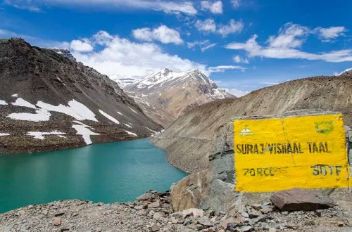
  • Suraj Tal Reflection: Located just below the summit on the Bhaga river side, Suraj Tal is the most iconic subject. For the best reflection shots of the surrounding peaks, arrive before 8:00 AM before the wind disturbs the water’s surface. Use a wide-angle lens from the roadside embankments to capture the full bowl of the lake.
  • The Cross-Range Panorama: From the summit marker, you have a 360-degree view of the Great Himalayan axis. Point your lens northwest to capture the dramatic descent toward Sarchu, where the landscape shifts from snow to the characteristic wind-eroded "canyon" formations.
  • Managing High-Altitude Albedo: The intense reflection from the snow and ice can easily trick your camera's light meter into underexposing the scene. Overexpose by +0.7 to +1.3 stops to ensure the snow remains white rather than grey, and use a circular polarizer to manage the glare off the glacial meltwater.
  • Harsh Weather and Gear Care: Baralacha La is prone to sudden blizzards and extreme cold even in mid-summer. Keep spare batteries inside your inner jacket pockets, as the sub-zero temperatures at the summit will deplete lithium-ion charges rapidly. Avoid changing lenses in the open due to the risk of fine glacial silt and moisture entering the camera body.
  • Congestion and Framing: As a primary transit point for heavy trucks and tourist convoys, the pass can get crowded by midday. To achieve "empty" landscape shots, focus on the higher ridges away from the summit marker or use a long exposure with a Neutral Density (ND) filter to blur out moving traffic.

Near By Attraction

Frequently Asked Questions About Baralacha La

The best time to visit Baralacha La is between June and September when the Manali Leh highway remains open and relatively stable. Snow clearance during these months allows safer road access.
Baralacha La is a high mountain pass located in the Lahaul region of Himachal Pradesh on the Manali Leh highway. It connects Himachal Pradesh with Ladakh at an altitude of over 4800 meters.
Baralacha La can be reached by road from Manali in Himachal Pradesh via the Manali Leh highway, which takes approximately 6 to 8 hours depending on traffic and weather. Travelers usually cross it while heading toward Leh in Ladakh.
Baralacha La is not open throughout the year due to heavy snowfall in winter. The pass generally remains closed from late October to May depending on weather conditions.
Indian travelers typically do not require a special permit to cross Baralacha La when traveling on the Manali Leh highway. Regulations may change, so checking current travel advisories before departure is advisable.
Most travelers spend 15 to 30 minutes at Baralacha La for photographs and short breaks. Longer stays are not recommended due to high altitude and low oxygen levels.
Baralacha La is situated at a very high altitude where oxygen levels are low and altitude sickness can occur. Proper acclimatization in places like Manali or Jispa before crossing is strongly recommended.
There are no permanent food stalls or fuel stations directly at Baralacha La. Travelers should refuel in Manali, Tandi, or Keylong and carry snacks and water before crossing the pass.
Road conditions at Baralacha La can include rough patches, water crossings, and sudden weather changes. Drivers should expect narrow stretches and exercise caution, especially after rainfall or snowfall.
Travelers crossing Baralacha La should carry warm clothing, sufficient drinking water, basic medicines, and emergency supplies. It is important to keep fuel levels adequate and ensure the vehicle is in good condition.

Loved this place ? Let’s Plan Your Himachal Pradesh Trip

Get customized Himachal Pradesh tour planning designed around season, road conditions, hill travel pacing, and comfort preferences. Whether you are visiting for snow experiences, mountain landscapes, temple towns, adventure activities, or relaxed valley s

⚑ Quick Response | πŸ’° Free consultation | πŸ•’ 24Γ—7 expert support

×

Plan Your Trip