+91 9910402252
admin@chalbanjare.com
| Entry Fee | No entry fee (temple visit is free; local parking charges may apply) |
|---|---|
| Timings | Open daily (daytime visit recommended; exact timings may vary as it is an open hill viewpoint) |
| Altitude (m) | Approx. 458 m |
| Ideal Visit Duration | 1 to 2 hours |
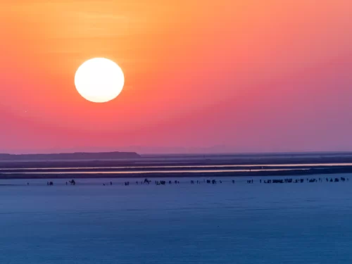
| Best Time of Day | Late afternoon to sunset for clear views over the Great Rann of Kutch |
| Crowd Level | Moderate to high during winter season and Rann Utsav months |
| Distance from City Centre (km) | Approx. 80 km from Bhuj city centre |
| Walking Difficulty | Easy (short walking near viewpoint and temple area) |
| Parking Available | Yes (parking available near the main viewpoint/temple zone) |
| Last Mile Access | Accessible by road up to the top; taxis and private vehicles commonly used |
| Suitable for Kids | Yes (requires supervision near hill edges) |
| Suitable for Seniors | Yes (minimal walking, but wind and uneven ground may be a factor) |
| Wheelchair Friendly | Partially (vehicle access is possible, but terrain near viewpoints is uneven) |
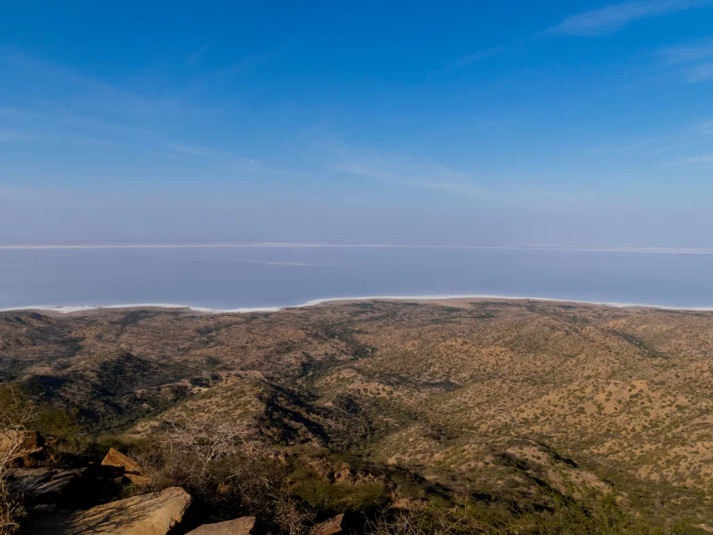
Visitors come to Kalo Dungar because it is the highest point in the Kutch region and offers one of the clearest elevated views of the Great Rann of Kutch. The hilltop viewpoint is especially popular during winter trips to the Rann, when visibility is high and the salt desert stretches clearly across the horizon.
The on-ground atmosphere is open and windy, with wide landscapes, rocky terrain, and a steady flow of tourists arriving by car or taxi. The area around the viewpoint and the Dattatreya Temple is active but not crowded like a city attraction, with most visitors spending time at the edge viewpoints and then moving through the small temple zone.
What makes Kalo Dungar distinct is the combination of hilltop altitude and salt desert scenery, which is rare in Gujarat travel routes. Sunset views over the Rann and the dramatic contrast between the dark rocky hill and the white salt flats make it a standout stop for travelers exploring the Kutch circuit.
Kalo Dungar is known mainly as a natural high point of the Kutch region, but it is also closely associated with the Dattatreya Temple located on the hilltop. The temple has made the site a regular pilgrimage stop for local communities and travelers visiting the Rann of Kutch circuit.
The location is culturally significant because it is considered a sacred hill destination in Kutch, with visitors often combining viewpoint travel with temple darshan. Over time, the hill gained wider recognition as a tourist viewpoint due to its panoramic visibility over the Great Rann of Kutch.
Kalo Dungar is best visited during the winter season when the Great Rann of Kutch has clear visibility and the hilltop weather is comfortable for outdoor viewing. Since the site is exposed and windy, season strongly affects the quality of the viewpoint experience, especially around sunset.
 Desert
The Rann of Kutch is a vast seasonal salt marsh located in the Kutch region of Gujarat, forming one of the largest salt deserts in the world.
Get customized Gujarat tour planning designed around seasonal climate conditions, long-distance road travel flow, festival timing, and realistic pacing across regions. Whether you are visiting for heritage sites, desert experiences, coastal retreats, wild
⚡ Quick Response | 💰 Free consultation | 🕒 24×7 expert support

