Stargazing in Hanle – Best Time and Travel Guide
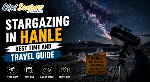
Hanle is one of India’s best stargazing destinations with dark skies, high altitude landscapes, observatory access, and minimal light pollution in eastern Ladakh.
+91 9910402252
admin@chalbanjare.com
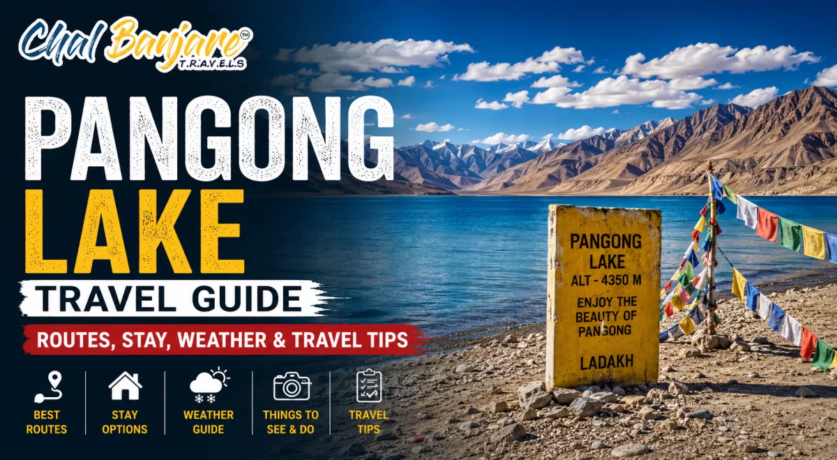
Pangong Lake travel requires proper planning around routes, permits, weather, accommodation, and altitude conditions in eastern Ladakh.
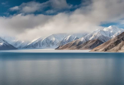
Pangong Lake, also known as Pangong Tso, is one of the most famous high-altitude lakes in Ladakh, located in eastern Ladakh near the Indo–China border. Stretching across barren Himalayan mountains and cold desert terrain, the lake sits at an elevation of around 14,000 feet and extends from India into Tibet. Only a portion of the lake lies within Indian territory, while the larger section continues across the international border.
Pangong became internationally popular because of its dramatic blue water shades, changing light reflections, isolated mountain landscapes, and cinematic visibility in travel media and films. The lake changes color throughout the day depending on sunlight, cloud movement, and weather conditions, creating one of the most visually striking landscapes in the Himalayas.
Travelers visiting Pangong should remember that the lake’s beauty depends heavily on weather and light conditions, which can change rapidly throughout the day. Overnight stays generally provide a much better experience compared to rushed same-day visits.
Pangong Lake lies at extremely high altitude, which means travelers commonly experience cold weather, low oxygen levels, strong winds, and physical fatigue during the journey. Even healthy travelers may notice breathlessness, headaches, dizziness, or weakness because the lake region remains above 14,000 feet with thin mountain air.
The climate around Pangong is harsh and dry throughout most of the year. Daytime sunlight can feel warm under clear skies, but temperatures drop sharply after sunset, especially during nights with strong winds from the lake and surrounding mountains. Weather changes also happen very quickly across the region.
| Condition | Main Impact | Ground Reality |
|---|---|---|
| High Altitude | Reduced oxygen levels | Breathlessness and fatigue common for travelers |
| Cold Nights | Sharp temperature drop | Heavy warm clothing becomes essential |
| Strong Winds | Increased cold exposure | Wind chill feels much colder near the lake |
| Dry Climate | Dehydration risk | Travelers need regular hydration |
| Rapid Weather Changes | Changing visibility and comfort | Sunny conditions can shift quickly |
| Altitude Fatigue | Reduced physical stamina | Long drives become physically exhausting |
| Limited Medical Support | Emergency access difficulty | Major healthcare facilities available mainly in Leh |
Travelers should spend proper acclimatization time in Leh before visiting Pangong because rapid altitude exposure greatly increases the risk of discomfort and altitude sickness. Slow travel and hydration improve overall comfort significantly.
The ideal number of days for Pangong Lake depends on whether travelers are visiting only the lake or combining it with Nubra Valley, Hanle, Tso Moriri, or larger Ladakh circuits. Although some tourists attempt same-day return journeys from Leh, such itineraries often become extremely tiring because of long mountain drives and high-altitude conditions.
An overnight stay near Pangong is generally considered the best option because it allows travelers to experience sunrise, sunset, changing lake colors, quieter evening conditions, and a slower travel pace. Travelers combining Pangong with eastern Ladakh circuits usually require additional days because road distances and terrain become more demanding.
Travelers who keep additional time for Pangong generally enjoy the region much more comfortably because the lake and surrounding landscapes are best experienced slowly rather than through rushed sightseeing schedules.
Spangmik is the most popular village near Pangong Lake and serves as the primary tourism base for travelers visiting the region. Located directly beside the lakeshore, the village offers some of the best panoramic views of Pangong Tso along with easy access to camps, guesthouses, photography points, and sunrise locations. Most overnight stays near Pangong are concentrated around Spangmik because of its scenic setting and comparatively better tourist infrastructure.
The changing colors of the lake, reflections of barren mountains, and dramatic sky conditions make Spangmik one of the most photographed destinations in Ladakh. Early mornings and late evenings provide the best light conditions for photography because the lake appears calmer and the surrounding mountains develop rich golden shades during sunrise and sunset.
Travelers staying in Spangmik should prepare for freezing nighttime temperatures and strong winds because the lakeside environment becomes extremely cold after dark, even during summer months.
Beyond the main Pangong tourism area near Spangmik, villages like Merak and Man offer quieter and more remote lakeside experiences for travelers wanting to explore less crowded sections of Pangong Tso. These villages lie farther along the lakeshore and provide a more peaceful atmosphere with wider landscapes, fewer tourists, and stronger interaction with traditional Changpa culture.
Road journeys towards Merak and Man pass through open high-altitude terrain where the lake appears increasingly isolated and scenic. These regions are ideal for travelers looking for slower travel experiences, landscape photography, village walks, and peaceful overnight stays away from the busiest Pangong tourist areas.
| Location | Main Highlight | Travel Experience |
|---|---|---|
| Merak Village | Quiet lakeside atmosphere | Less crowded compared to Spangmik |
| Man Village | Remote Pangong landscapes | Traditional Himalayan village environment |
| Lakeside Roads | Scenic driving routes | Wide panoramic lake and mountain views |
| Changpa Settlements | Nomadic Himalayan culture | Yak and livestock grazing common nearby |
| Photography Conditions | Open natural scenery | Excellent sunrise and sunset opportunities |
| Remote Stay Experience | Minimal tourist activity | Peaceful and isolated environment |
| Night Sky Visibility | Dark sky atmosphere | Clear star visibility during stable weather |
Travelers visiting Merak and Man should carry sufficient essentials because infrastructure and emergency support become more limited farther away from the main Pangong tourist zone. Slow travel provides the best experience across these remote lakeside regions.
The road journey to Pangong Lake itself is one of Ladakh’s major attractions because it passes through high mountain passes, river valleys, barren landscapes, and remote Himalayan settlements. Regions like Chang La, Durbuk, and Tangtse form important transit points along the route and offer dramatic scenery throughout the journey from Leh towards Pangong.
Chang La is one of the highest motorable mountain passes in Ladakh and acts as the main gateway towards Pangong Lake from Leh. Beyond the pass, the route gradually descends towards Tangtse and Durbuk through wide valleys and cold desert terrain before finally reaching the lakeshore region.
Travelers should begin the Pangong journey early in the morning because mountain weather and road conditions can become more difficult later in the day. Careful driving is extremely important while crossing Chang La and remote eastern Ladakh highways.
Summer is considered the best season to visit Pangong Lake because road connectivity improves, weather conditions remain comparatively stable, and the lake displays its most vibrant blue shades under clear Himalayan skies. The main tourist season generally begins around May or June after the opening of high mountain passes and continues until September.
During summer, travelers can comfortably access Pangong through Chang La and eastern Ladakh highways while enjoying pleasant daytime conditions and excellent visibility around the lake. The combination of blue water reflections, barren mountain landscapes, and clear skies creates ideal conditions for sightseeing, photography, camping, and overnight stays near the lakeshore villages.
Travelers planning Pangong during summer should still carry proper winter clothing because the lakeside region remains extremely cold and windy during evenings and nights despite warmer daytime conditions.
Winter completely transforms Pangong Lake into a frozen Himalayan landscape with icy winds, snow-covered mountains, and extremely harsh temperatures across eastern Ladakh. During peak winter months, large portions of the lake freeze completely, creating one of the most dramatic cold desert environments in the Indian Himalayas.
Although winter travel to Pangong attracts adventure travelers and photographers because of the frozen lake scenery, the season remains physically demanding due to severe cold, icy roads, limited accommodation options, and reduced infrastructure support. Temperatures often fall drastically below freezing during nights, making proper winter preparation absolutely essential.
| Winter Condition | Main Impact | Ground Reality |
|---|---|---|
| Frozen Lake Surface | Lake partially or fully freezes | Unique winter landscape experience |
| Extreme Temperatures | Severe cold exposure | Nights become dangerously cold |
| Snowfall | Road accessibility challenges | Travel disruptions possible during heavy snow |
| Black Ice Roads | Driving risk increases | Morning and night travel become difficult |
| Limited Camps and Hotels | Reduced tourist facilities | Many seasonal stays close during winter |
| Strong Winds | Higher wind chill effect | Outdoor exposure becomes uncomfortable quickly |
| Clear Winter Skies | Sharp mountain visibility | Excellent conditions for photography |
Travelers visiting Pangong during winter should carry heavy thermal clothing, emergency medicines, gloves, insulated footwear, and backup essentials because eastern Ladakh winter conditions can become extremely harsh very quickly.
Pangong Lake experiences major seasonal weather variation throughout the year because of its high altitude and remote eastern Ladakh location. Travel suitability depends mainly on road accessibility, snowfall conditions, temperature variation, and the traveler’s preference for sightseeing, photography, camping, or winter exploration.
Most tourists prefer visiting between June and September because road conditions remain comparatively stable and accommodation facilities operate actively during these months. Shoulder and winter seasons offer quieter travel experiences but involve colder temperatures and greater weather-related uncertainty.
| Month or Season | Weather Conditions | Travel Suitability |
|---|---|---|
| April | Cold weather with snow presence near passes | Road status may remain uncertain |
| May | Road opening period with improving temperatures | Early tourist movement begins gradually |
| June | Stable summer weather | Excellent for road trips and lake exploration |
| July and August | Peak travel season | Best overall accessibility and tourism activity |
| September | Clear skies and cooler nights | Excellent for photography and quieter travel |
| October | Rapid temperature drop and early snowfall risk | Cold but scenic shoulder season |
| November to March | Extreme winter and frozen lake conditions | Suitable mainly for experienced winter travelers |
Travelers planning Pangong trips should always monitor weather forecasts and road status before departure because Chang La and eastern Ladakh highways can become weather-sensitive during shoulder and winter months. Flexible travel planning greatly improves comfort and safety.
The Leh to Pangong Lake route via Chang La Pass is the most popular and commonly used road connection to Pangong Tso. This journey takes travelers through dramatic mountain landscapes, high-altitude valleys, snow-covered passes, and remote eastern Ladakh terrain before reaching the lakeshore villages around Pangong.
The route generally starts from Leh and continues through Karu, Sakti, Chang La, Durbuk, and Tangtse before finally reaching Spangmik and nearby Pangong villages. Chang La Pass acts as the main gateway towards Pangong and is among the highest motorable mountain passes in Ladakh. Because of the high altitude and changing weather conditions, the journey requires careful driving and proper acclimatization.
Travelers should begin early from Leh because mountain weather changes rapidly later in the day. Carrying warm clothing, water, and emergency essentials is important because Chang La conditions can become extremely cold even during summer.
The Nubra Valley to Pangong route via the Shyok road is one of the most scenic and time-saving road connections in Ladakh because it directly links Nubra Valley with Pangong Lake without requiring a return journey through Leh. This route has become increasingly popular among travelers wanting a circular Ladakh itinerary covering Nubra and Pangong efficiently.
The journey usually begins from Hunder or Diskit in Nubra Valley and continues through Agham and Shyok village before joining the Pangong highway near Durbuk. The road passes through river valleys, barren mountains, and isolated landscapes, offering a completely different experience compared to the Chang La route from Leh.
| Route Section | Main Highlight | Travel Conditions |
|---|---|---|
| Diskit and Hunder | Nubra Valley departure region | Popular tourist base with hotels and fuel access |
| Agham Route | Remote mountain roads | Narrow sections and changing road quality |
| Shyok Village | River valley landscapes | Scenic but weather-sensitive route |
| Durbuk Junction | Connection towards Pangong | Road quality improves near the main highway |
| Pangong Arrival | Lake and mountain scenery | Long but visually dramatic road journey |
| River Crossing Areas | Glacier-fed streams | Road conditions may change after rainfall |
| Travel Experience | Circular Ladakh route advantage | Avoids unnecessary return travel to Leh |
Travelers using the Shyok route should always confirm road conditions before departure because landslides, water crossings, and weather changes can affect accessibility unexpectedly. Early morning departures improve safety and travel comfort.
The Pangong to Hanle and Tso Moriri circuit is one of the most adventurous and scenic routes in eastern Ladakh because it connects remote lakes, Changthang plains, military-controlled regions, monasteries, and isolated Himalayan highways within a single extended journey. This route is ideal for travelers wanting to explore eastern Ladakh beyond regular tourist circuits.
Most travelers move from Pangong towards Chushul, Tsaga, and Loma before reaching Hanle. From Hanle, the route continues through Nyoma and Mahe towards Tso Moriri and Korzok village. Because these roads pass through sensitive border areas and remote terrain, Inner Line Permits, fuel planning, and proper acclimatization are extremely important.
Travelers planning this eastern Ladakh circuit should maintain flexible schedules because weather conditions and road quality can affect travel speed significantly. Carrying extra fuel, warm clothing, medicines, and offline maps is essential throughout the route.
A one day Pangong Lake trip from Leh is possible, but it is physically demanding because the journey involves long driving hours across high-altitude mountain roads, Chang La Pass, and remote eastern Ladakh terrain. Many travelers choose this option when they have limited time in Ladakh, but the itinerary usually becomes exhausting due to continuous road travel with very little rest.
The route from Leh to Pangong and back generally requires an entire day of travel with early morning departure and late evening return. Although travelers can briefly experience the lake and surrounding scenery, the itinerary leaves limited time for photography, relaxation, or enjoying sunrise and sunset conditions around Pangong.
Travelers choosing a same-day Pangong trip should remain realistic about the physical difficulty of the journey because high-altitude roads and long travel hours can quickly cause fatigue. Overnight stays provide a far more comfortable and enjoyable experience.
Combining Pangong Lake with Nubra Valley is one of the most popular Ladakh itinerary combinations because it allows travelers to experience mountain passes, sand dunes, monasteries, remote villages, and high-altitude lakes within a single route circuit. Most travelers spend one night in Nubra Valley and another night near Pangong Lake for a more comfortable travel pace.
The route usually begins from Leh towards Nubra Valley through Khardung La Pass and continues towards Pangong via the Shyok road. This circular route avoids unnecessary return journeys and provides a broader Ladakh experience with changing landscapes throughout the trip.
| Day | Suggested Route | Main Coverage |
|---|---|---|
| Day 1 | Leh to Nubra Valley | Khardung La, Diskit, Hunder sand dunes |
| Day 2 | Nubra to Pangong | Shyok route, river valleys, Pangong Lake |
| Day 3 | Pangong to Leh | Chang La Pass and eastern Ladakh landscapes |
| Optional Extension | Additional village stays | Turtuk or remote Pangong regions |
This route combination is much more comfortable than attempting Pangong separately as a same-day journey because overnight stays reduce travel fatigue and provide more time to experience the lake and surrounding landscapes properly.
The Pangong–Hanle–Tso Moriri circuit is one of the most scenic and adventurous extended itineraries in Ladakh because it connects high-altitude lakes, Changthang plains, observatory regions, monasteries, and remote Himalayan highways within a single continuous journey. This route is ideal for travelers wanting to explore eastern Ladakh beyond the regular tourist circuit.
The itinerary generally begins from Pangong Lake and continues through Chushul, Tsaga, and Loma towards Hanle before moving towards Nyoma, Mahe, and Tso Moriri. Because the route passes through isolated border-region terrain with limited infrastructure, travelers should prioritize acclimatization, fuel planning, permits, and flexible travel schedules.
Travelers attempting this extended circuit should keep additional buffer days because weather changes, road conditions, and altitude fatigue can affect travel speed significantly. Slow travel and realistic daily driving schedules are essential for safely exploring eastern Ladakh.
Transport forms the biggest part of a Pangong Lake trip budget because the lake is located deep inside eastern Ladakh with long driving distances, high-altitude roads, and limited public transport connectivity. Travelers generally choose between private taxis, bike rentals, shared cabs, or self-drive vehicles depending on budget, comfort preference, and travel style.
Private taxis remain the most comfortable option for Pangong because local Ladakh drivers are familiar with mountain conditions, Chang La weather, and high-altitude driving challenges. Bike trips are extremely popular among adventure travelers, but fuel planning and weather preparation become very important because long mountain routes reduce fuel efficiency considerably.
| Travel Option | Main Advantage | Ground Reality |
|---|---|---|
| Private Taxi | Comfortable and reliable travel | Most expensive but easiest transport option |
| Shared Taxi | Lower travel cost | Limited flexibility and fixed departure timing |
| Bike Rental | Adventure road trip experience | Cold weather and rough roads increase riding fatigue |
| Self Drive Vehicle | Flexible itinerary planning | Requires mountain driving confidence |
| Fuel Expenses | High-altitude road travel | Mileage reduces significantly on mountain routes |
| Extended Circuits | Pangong with Nubra or Hanle | Transport cost increases considerably |
| Extra Fuel Backup | Remote eastern Ladakh travel | Important for bikes and long circuits |
Travelers planning Pangong trips should always keep an additional emergency budget because weather delays, route diversions, or mechanical issues can increase transport expenses unexpectedly in remote Himalayan regions.
Accommodation near Pangong Lake mainly consists of camps, cottages, guesthouses, and local homestays spread across villages like Spangmik, Man, and Merak. Most stays operate seasonally because extreme winter conditions make tourism difficult during colder months. Compared to Leh, accommodation facilities near Pangong are more basic and heavily dependent on weather and road accessibility.
Spangmik remains the main accommodation hub around the lake because of its direct lakeside location and better tourist infrastructure. Travelers looking for quieter experiences often prefer staying farther towards Merak or Man village where tourism is less crowded and the atmosphere feels more remote.
Travelers staying overnight near Pangong should keep realistic comfort expectations because the region remains remote with limited infrastructure. The natural landscape and lakeside atmosphere are the main highlights rather than luxury accommodation experiences.
Apart from transport and accommodation, travelers should also budget for permits, environmental charges, food expenses, emergency supplies, and unexpected travel costs while visiting Pangong Lake. Because the region lies within restricted eastern Ladakh territory, Inner Line Permits are mandatory for most travelers entering Pangong routes.
Food prices near Pangong are generally higher than Leh because supplies must be transported over long high-altitude routes. Hidden expenses can also increase during extended itineraries involving Nubra Valley, Hanle, or Tso Moriri because fuel usage, route permits, and emergency travel changes become more significant across remote mountain regions.
| Expense Type | Main Purpose | Practical Ground Reality |
|---|---|---|
| Inner Line Permit | Restricted area access | Mandatory for Pangong travel |
| Environmental Charges | Tourism management fees | Added during permit processing |
| Food Expenses | Meals in remote regions | Higher pricing because of transport difficulty |
| Warm Clothing Rental | Cold-weather protection | Useful for unprepared travelers |
| Vehicle Repairs | Mountain road damage | Unexpected expenses possible during road trips |
| Extra Fuel | Remote route backup | Necessary for longer eastern Ladakh circuits |
| Medical Supplies | Altitude and emergency support | Limited pharmacy access near Pangong |
| Emergency Accommodation | Weather-related delays | Additional overnight stays may become necessary |
Travelers planning Pangong trips should always keep a flexible emergency budget because weather conditions, altitude issues, and mountain road disruptions can suddenly increase overall travel expenses across eastern Ladakh.
Pangong Lake lies within a restricted border region of eastern Ladakh, which is why Inner Line Permits are mandatory for most travelers visiting the area. Since the lake is located near the Indo–China border, military presence and security checkpoints remain common throughout the route, especially near Chang La, Tangtse, and eastern lakeside regions.
Travelers usually arrange permits in Leh before starting the journey towards Pangong. The permit process can be completed online or through local travel agents, hotels, and taxi operators who assist travelers with route approvals and document preparation. Travelers combining Pangong with Nubra Valley, Hanle, Chushul, or Tso Moriri should ensure that all intended regions are clearly mentioned in the permit.
Travelers should always verify the latest permit regulations before departure because eastern Ladakh travel rules occasionally change depending on weather conditions, security requirements, and road accessibility.
Carrying proper identification and travel documents is extremely important while visiting Pangong Lake because multiple checkpoints, permit inspections, accommodation verification procedures, and restricted area regulations apply throughout eastern Ladakh. Missing or incomplete paperwork can create major travel delays during the journey.
Indian and foreign travelers must organize all required documents before leaving Leh because printing, internet access, and administrative support remain limited across Pangong and remote eastern Ladakh regions. Multiple photocopies are especially useful because checkpoints may collect document copies during route verification.
| Document Type | Main Purpose | Ground Reality |
|---|---|---|
| Government Photo ID | Identity verification | Required at hotels and checkpoints |
| Inner Line Permit | Restricted area access approval | Mandatory for Pangong travel |
| Passport | Identity proof for foreign travelers | Must be carried throughout the journey |
| Visa Documents | International travel authorization | Required for foreign tourists |
| Driving License | Vehicle operation approval | Necessary for riders and self-drive travelers |
| Vehicle Registration Papers | Vehicle ownership verification | Checked during road inspections |
| Vehicle Insurance | Travel compliance | Important during police or checkpoint verification |
| Hotel Booking Copies | Travel confirmation support | Useful in low-network regions |
| Photocopies of Documents | Checkpoint submission | Multiple copies recommended |
Travelers carrying organized paperwork generally experience much smoother movement across Pangong and eastern Ladakh because checkpoint verification remains frequent throughout these remote mountain routes.
Pangong Lake is one of the most photographed destinations in Ladakh because of its changing blue water colors, mountain landscapes, and dramatic high-altitude scenery. However, travelers should remember that the region lies close to sensitive military zones and international border areas where photography restrictions apply in several locations.
Army camps, bridges, checkpoints, military vehicles, radar installations, and restricted security areas should never be photographed without permission. Drone usage is also heavily restricted in most parts of Ladakh because of military sensitivity and border security regulations. Travelers should therefore follow all local instructions carefully while exploring Pangong and nearby eastern Ladakh routes.
Travelers should always prioritize responsible behavior while visiting Pangong because eastern Ladakh remains strategically sensitive. Respecting photography and drone restrictions ensures safer and smoother travel throughout the region.
Pangong Lake lies at an altitude of more than 14,000 feet, which means travelers frequently experience physical discomfort caused by low oxygen levels, cold weather, and rapid altitude gain during the journey. Many visitors underestimate the effect of high altitude because Pangong is often included in short Ladakh itineraries immediately after arriving in Leh.
Travelers who do not acclimatize properly before visiting Pangong commonly experience headache, dizziness, nausea, breathlessness, fatigue, and difficulty sleeping. The journey across Chang La Pass further increases altitude exposure and physical exhaustion because the pass itself lies at an even higher elevation than the lake region.
Travelers should avoid rushing directly to Pangong immediately after arriving in Leh because proper acclimatization significantly improves comfort and reduces the possibility of serious altitude-related complications during the trip.
Infrastructure around Pangong Lake remains limited because the region is extremely remote and located close to sensitive border areas of eastern Ladakh. Travelers should not expect reliable internet, continuous electricity, advanced medical facilities, or frequent ATM access while staying near the lake.
Mobile networks become weak or completely unavailable in several route sections after crossing Chang La, while digital payments often fail because of unstable connectivity. Medical facilities near Pangong are basic, and serious emergencies generally require evacuation towards Leh where proper healthcare infrastructure is available.
| Infrastructure Limitation | Main Issue | Ground Reality |
|---|---|---|
| Mobile Network | Weak or no connectivity | Several regions remain completely offline |
| Internet Access | Unstable or unavailable | Digital services frequently fail remotely |
| ATM Facilities | Very limited banking access | Cash should be carried from Leh |
| Electricity Supply | Power interruptions possible | Charging access may remain inconsistent |
| Medical Facilities | Basic healthcare support only | Major treatment available mainly in Leh |
| Pharmacy Availability | Limited medicine access | Personal medicines should always be carried |
| Vehicle Repair Support | Minimal mechanical assistance | Remote breakdowns may cause major delays |
Travelers heading towards Pangong should carry enough cash, power banks, medicines, offline maps, and emergency essentials because eastern Ladakh conditions make infrastructure support much more limited than regular tourist destinations.
Travel conditions around Pangong Lake depend heavily on weather because eastern Ladakh roads remain highly sensitive to snowfall, landslides, strong winds, black ice, and sudden mountain climate changes. Even during summer months, weather disruptions can affect travel timing and road accessibility unexpectedly.
Chang La Pass is one of the most weather-sensitive sections on the Pangong route because snowfall and icy conditions can quickly reduce visibility and road safety. During shoulder and winter seasons, temporary roadblocks and travel delays become more common due to snow accumulation and difficult mountain conditions.
Travelers planning Pangong trips should always keep additional buffer time because mountain weather can change rapidly in eastern Ladakh. Early departures and flexible schedules improve both safety and overall travel comfort significantly.
One of the most common mistakes travelers make while visiting Pangong Lake is attempting a same-day return trip from Leh immediately after arriving in Ladakh. Although technically possible, this itinerary becomes extremely exhausting because travelers spend most of the day driving through high-altitude mountain roads with very little time to rest or acclimatize properly.
The journey includes crossing Chang La Pass and spending several hours above 14,000 feet, which increases the chances of altitude sickness, fatigue, headache, and breathing discomfort. Travelers often underestimate how physically demanding eastern Ladakh roads become at high altitude, especially when combined with poor acclimatization and continuous travel.
Travelers planning Pangong should ideally stay overnight near the lake because slower travel provides a safer, more comfortable, and far more enjoyable experience compared to rushed return journeys from Leh.
Pangong Lake lies in a remote high-altitude region where weather conditions, connectivity, and infrastructure remain highly unpredictable. Travelers often arrive unprepared for the freezing temperatures, limited medical access, and weak mobile network coverage that are common across eastern Ladakh.
Even during summer months, nights near Pangong become extremely cold because of strong winds and high altitude. Medical stores and emergency support are also very limited around the lake, making personal preparation extremely important before starting the journey from Leh.
| Essential Item | Main Importance | Ground Reality |
|---|---|---|
| Heavy Warm Clothing | Protection from freezing nights | Temperatures drop sharply after sunset |
| Thermal Layers | Cold-weather comfort | Useful even during summer travel |
| Personal Medicines | Altitude and emergency support | Medical facilities remain limited remotely |
| Postpaid SIM Cards | Better network compatibility | Prepaid connections often fail in Ladakh |
| Power Banks | Electricity backup | Charging access may remain inconsistent |
| Portable Oxygen | Emergency altitude support | Helpful for sensitive travelers |
| Offline Maps | Navigation support | Internet access becomes unreliable remotely |
| Water and Snacks | Long-distance travel support | Limited food stops across remote routes |
Travelers carrying proper essentials generally face far fewer difficulties during Pangong trips because eastern Ladakh infrastructure remains limited. Preparation becomes much more important than relying on local facilities in remote mountain regions.
Choosing the correct stay location around Pangong Lake greatly affects the overall travel experience because different villages offer different levels of accessibility, crowd levels, lake views, and infrastructure comfort. Most travelers stay in Spangmik because it provides direct lakeside access and the largest concentration of camps, cottages, and guesthouses.
Travelers looking for quieter and less crowded experiences often prefer villages like Man and Merak, which lie farther along the lake and provide a more peaceful atmosphere with wider landscapes and fewer tourist vehicles. However, infrastructure and connectivity become more limited as travelers move farther away from the main tourism zone.
Travelers should prioritize comfort, weather preparation, and realistic expectations while choosing Pangong stays because the region remains remote and infrastructure is basic compared to Leh. Overnight lakeside stays provide a much richer experience of Pangong’s changing colors and mountain atmosphere.
The best Pangong Lake route combination usually depends on the number of travel days and the type of Ladakh experience travelers want. For most visitors, combining Pangong with Nubra Valley creates the most balanced itinerary because it covers mountain passes, sand dunes, monasteries, villages, and high-altitude lake scenery within a comfortable circular route.
Travelers with additional days often extend the journey further into eastern Ladakh by combining Pangong with Hanle and Tso Moriri. This longer circuit passes through remote Changthang plains, Chushul, Nyoma, and isolated Himalayan highways, creating one of the most scenic road trip experiences in Ladakh.
Travelers planning extended Pangong circuits should maintain flexible schedules because road conditions and weather changes can affect travel timing across remote eastern Ladakh regions. Slower travel always provides a safer and more enjoyable experience.
Choosing between a same-day Pangong trip and an overnight stay depends mainly on available time, physical stamina, and the type of experience travelers want. A same-day trip from Leh is possible, but it involves very long driving hours across Chang La Pass with limited time at the lake itself.
An overnight stay near Pangong is generally considered the much better option because travelers can experience sunrise, sunset, changing lake colors, quieter evening conditions, and reduced travel fatigue. Overnight travel also allows more time to acclimatize gradually instead of rushing through high-altitude roads continuously.
| Travel Style | Main Advantage | Travel Limitation |
|---|---|---|
| Same Day Trip | Suitable for limited schedules | Extremely tiring because of long driving hours |
| Overnight Stay | Comfortable and relaxed experience | Requires additional accommodation planning |
| Sunrise and Sunset Stay | Best photography opportunities | Cold night temperatures near the lake |
| Extended Circuit Travel | Combines Pangong with Nubra or Hanle | Requires additional acclimatization and travel days |
| Same-Day Return | Lower accommodation cost | High altitude fatigue increases significantly |
| Overnight Acclimatization | Slower and safer mountain travel | Basic infrastructure near the lake |
Travelers visiting Pangong for the first time generally enjoy the lake much more through an overnight stay because the region’s atmosphere, lighting conditions, and mountain scenery are best experienced slowly rather than through rushed travel schedules.
Before visiting Pangong Lake in 2026, travelers should carefully plan permits, acclimatization, weather preparation, fuel strategy, accommodation bookings, and emergency essentials because eastern Ladakh remains a remote and weather-sensitive Himalayan region. Proper planning greatly improves both safety and comfort during the journey.
Many travel problems near Pangong occur because visitors underestimate altitude, road conditions, freezing temperatures, and infrastructure limitations around the lake. A practical checklist helps travelers stay prepared for high-altitude conditions and long mountain road journeys.
A successful Pangong journey depends more on preparation, acclimatization, and realistic travel pacing than on covering maximum destinations quickly. Travelers who move slowly and plan carefully usually enjoy the lake and eastern Ladakh landscapes much more comfortably.
Get customized Ladakh tour planning designed around altitude comfort, acclimatization time, weather windows, and real Himalayan road conditions. Whether you are visiting for high mountain passes, monasteries, lakes, or remote valley experiences, our exper
⚡ Quick Response | 💰 Free consultation | 🕒 24×7 expert support